Related Research Articles

The Indonesian island of Sumatra is located in a highly seismic area of the world. In addition to the subduction zone off the west coast of the island, Sumatra also has a large strike-slip fault, the Great Sumatran Fault also known as Semangko Fault, running the entire length of the island. This fault zone accommodates most of the strike-slip motion associated with the oblique convergence between the Indo-Australian Plate and Eurasian Plate The fault ends in the north just below the city of Banda Aceh, which was devastated in the 2004 Indian Ocean earthquake. After the December 2004 earthquake, pressure on the Great Sumatran Fault has increased tremendously, especially in the north.

The 1,600 kilometres (990 mi) long Macquarie Fault Zone is a major right lateral-moving transform fault along the seafloor of the south Pacific Ocean which runs from New Zealand southwestward towards the Macquarie Triple Junction. It is also the tectonic plate boundary between the Australian Plate to the northwest and the Pacific Plate to the southeast. As such it is a region of high seismic activity and recorded the largest strike-slip event on record up to 23 May 1989, of at least Mw8.0
On 2 July 2013, an earthquake struck the Indonesian island of Sumatra on 2 July with a moment magnitude of 6.1 and a maximum Mercalli intensity of VI (Strong). The strike-slip earthquake killed at least 43 people and injured more than 2,500 others in the province of Aceh where approximately 4,300 homes were damaged or destroyed.
The Palu-Koro Fault or Palu-Koro Fault System is a major active NNW-SSE trending left-lateral strike-slip fault zone on the island of Sulawesi in Indonesia. It caused the 2018 Sulawesi earthquake and tsunami.

The 2019 North Maluku earthquake, a shallow 7.2 magnitude earthquake, struck the island of Halmahera, North Maluku, Indonesia on 14 July 2019 at 18:10 local time with its epicentre located at South Halmahera. It struck at a shallow depth of 10 km (6.2 mi) near Labuha, a small port town located in Bacan Island. The earthquake produced a non-destructive 20 cm tsunami, which struck Labuha just minutes after the shaking started. 14 people were killed by the earthquake while 129 people were injured, and more than 50,000 people were displaced. The earthquake inflicted a total damage of Rp 238 billion.
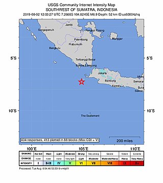
The 2019 Sunda Strait earthquake occurred on the night of 2 August 2019, when a magnitude 6.9 earthquake rattled Sunda Strait at a moderate depth of 52.8 kilometres. The epicentre was located 214 km from Bandar Lampung, the capital of Lampung and 147 km west of Sumur, Pandeglang Regency. The earthquake struck with a maximum intensity of VI (Strong). The earthquake prompted a tsunami warning in the area, with authorities urging coastal residents to immediately evacuate to higher grounds.

On February 20, 2008, an earthquake with a moment magnitude of 7.4 struck off the coast of Sumatra at a hypocentre depth of 26 km. The earthquake had an epicenter located on the island of Simeulue, northwest from Sinabang, a small town on the island. Three people were killed and an additional 25 seriously injured as a result of the earthquake.

The 1834 Java earthquake struck the Dutch East Indies island of Java, in the city of Bogor. The earthquake occurred on the morning of October 11, 1834. It was assigned VIII (Severe) to IX (Violent) on the Modified Mercalli intensity scale.

The Lembang Fault is an active fault located 10 km north of the city of Bandung on the Indonesian island of Java. This sinistral slip fault is estimated to measure 29 km in length. While no historical earthquakes have occurred, the fault is thought to be possible of generating a magnitude 6.5 to 7.0 earthquake in the future. Because of the potential for large and damaging earthquakes on the fault, the Meteorology, Climatology and Geophysics Agency (BMKG) has been monitoring activity on the fault.
The 2021 Bali earthquake struck at 04:18 local time (UTC+08:00) when people were still sleeping on 15 October 2021. It resulted in 4 deaths and 73 more injured, despite having a moment magnitude of 4.7.

An earthquake occurred 112 km, offshore, north of Maumere in the Flores Sea on 14 December. The quake had a moment magnitude of 7.3 according to the United States Geological Survey (USGS). One person was killed and 173 others suffered injuries.

On 25 February 2022 at 08:39 WIB, a moment magnitude (Mw ) 6.2 earthquake struck West Sumatra, Indonesia at a depth of 4.0 km (2.5 mi). Preceded by one foreshock and followed by over 200 aftershocks, the mainshock had an epicenter at the foot of Mount Talakmau in Pasaman Regency. The mainshock was the result of strike-slip faulting along a previously unidentified segment of the Great Sumatran Fault. At least 27 people died, 457 were injured, and 19,221 others were displaced. It inflicted 780 million Indonesian rupiahs (Rp) worth of damage. The heaviest damage was recorded at three villages around Mount Talakmau. Landslides and flash floods caused additional damage and casualties.
The 1933 Sumatra earthquake or Liwa earthquake occurred in West Lampung Regency, Lampung Province, Indonesia on June 25. The earthquake had an estimated surface-wave magnitude (Ms ) of 7.7 occurring at a shallow depth of 20 km. It had an epicenter onshore, devastating the city of Liwa. At least 788 people were reported killed, although the death toll may have been in the thousands. Aftershocks followed, including one which was strong enough to cause additional fatalities. The mainshock also triggered a nearby volcanic eruption two weeks later, killing some people.
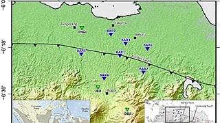
The Baribis Fault is a geological feature located in the northern part of Java. This fault, estimated to be 100 kilometers long, stretches from Purwakarta to Lebak Regency and is a threat to the Jakarta metropolitan area because the fault is partially located within the metropolitan area itself.
The February 2004 Nabire earthquakes began on February 6 at 06.05 WIT in Nabire Regency, Central Papua, Indonesia. The first of three large earthquakes measured 7.0 on the moment magnitude scale (Mw ). It was followed a few days later by two strong shocks, measuring Mw 7.3 and 6.7, respectively. The earthquakes were felt at Nabire with a maximum Mercalli intensity of VI (Strong). At least 37 people were killed and were 682 injured, and over 2,600 buildings were damaged or destroyed.

On 21 November 2022, at 13:21 WIB (UTC+07:00), a Mww 5.6 earthquake struck near Cianjur in West Java, Indonesia. The strike-slip earthquake occurred with a focal depth of 11 km (6.8 mi). Between 335 and 635 people died, 7,729 were injured and five remain missing. More than 62,628 homes were damaged across 16 districts in Cianjur Regency and the surrounding region. It is the deadliest earthquake to affect Indonesia since the 2018 Sulawesi earthquake. Damage evaluated after the event earned it a maximum Modified Mercalli intensity of VIII (Severe).
An earthquake affected the island of Java, Indonesia on 22 January 1780. The source and magnitude of the earthquake remains debated among seismologists. Proposed origins of the earthquake include shallow inland back-arc thrusting along a fault located within the upper crust on the island or rupture of the subduction zone off the southern coast of Java. The magnitude of the earthquake is estimated to be at least 8.5, while other sources usually refer to it with a range of Mw 8.0 to 8.5 for the megathrust earthquake. For the shallow crustal earthquake source, the magnitude range is Mw 7.0 to 8.0.
On 18 September 2024, at 09:41:06 WIB, a Mw 5.1 earthquake struck Bandung Regency in West Java, Indonesia, 16 km (9.9 mi) east-southeast of Banjar.
References
- ↑ "DINAMIKA SESAR CITARIK". Jurnal Geologi Dan Sumberdaya Mineral. 18 (3): 149–162. 6 June 2008. Retrieved 14 December 2023.
- ↑ "6 Sesar Aktif di Jawa Barat, Tidak Hanya Sesar Cimandiri dan Sesar Baribis". Kompas.com. 23 November 2022. Retrieved 14 December 2023.
- ↑ "Gempa Bumi Kalapanunggal, Sukabumi: Satu Bukti Aktivitas Sesar Citarik". Niaga.Asia. 11 March 2020. Retrieved 14 December 2023.
- ↑ "Gempa Bumi Belasan Kali Terjadi di Perbatasan Sukabumi, Bogor, Banten: Sesar Citarik Menggeliat". Tribun Jabar. 7 December 2023. Retrieved 14 December 2023.
- ↑ "Indonesia's Historical Earthquakes Modelled examples for improving the national hazard map". Researchgate. January 2015. Retrieved 14 December 2023.
- ↑ "Sesar Citarik, Sesar Aktif Gempa Dekat Bogor, Jakarta dan Bekasi". Viral BEKASI. 25 November 2022. Retrieved 14 December 2023.
- ↑ "Tanah Lunak Jakarta Perbesar Guncangan Gempa, BNPB Minta DKI Cek Bangunan". detiknews. 8 July 2020. Retrieved 14 December 2023.