This article needs additional citations for verification .(July 2022) |
Indonesia is a country located close to tectonic plate boundaries which causes it to have many active faults and is prone to earthquakes, [1]
This article needs additional citations for verification .(July 2022) |
Indonesia is a country located close to tectonic plate boundaries which causes it to have many active faults and is prone to earthquakes, [1]

The Great Sumatran fault, also known as Semangko fault, is a large strike-slip fault running the entire length of the island of Sumatra. This Indonesian island is located in a highly seismic area of the world, including a subduction zone off the west coast of the island.

A Mw 6.4 earthquake struck the island of Lombok on the morning of 29 July 2018 at a shallow depth of 14 km (8.7 mi). Widespread damage was reported in the area, and authorities confirmed that 20 people were killed in the earthquake while hundreds were injured.
On 5 August 2018, a destructive and shallow earthquake measuring Mw 6.9 struck the island of Lombok, Indonesia. It was the main shock following its foreshock, a nearby Mw 6.4 earthquake on 29 July. It was followed by a nearby 6.9 earthquake on 19 August 2018.
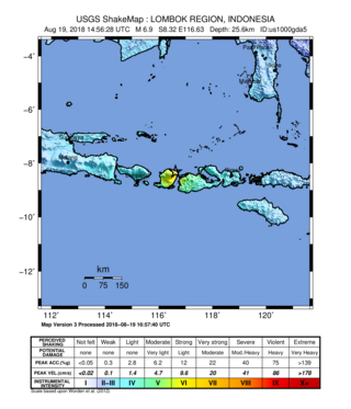
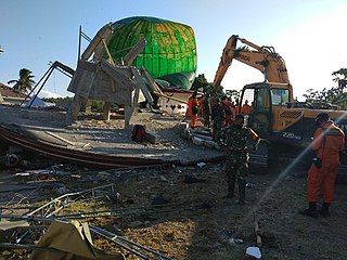
On 19 August 2018 a major earthquake struck with high intensity on the northeast corner of Lombok and northwest Sumbawa at 22:56 local time, a few km to the east of a series of quakes that had been rocking the area for the past 3 weeks. It was measured at Mw 6.9 (USGS), at a depth of 21.0 km. The Indonesian BMKG announced that it was a new major earthquake and not an aftershock. The earthquake occurred on the same overall structure, the Flores back-arc thrust fault. However, according to scientists, it happened on a different thrust fault as there are many individual structures within the belt. There were 14 deaths and 1800 homes were damaged, around half of them severely, due to this event, including deaths on Sumbawa, following 2 deaths from the previous Lombok quake roughly 24 hours earlier. Heavy tiles fell from the local mosque, and 143 patients were treated outdoors in makeshift tents for injuries on Sumbawa.

On 11 October 2018, an earthquake struck off the coast of East Java, Indonesia, with the epicentre located off the coast of Situbondo Regency. The earthquake, which struck at dawn, killed four people in addition to destroying or damaging hundreds of houses, mostly on the small island of Sapudi.

The 2019 North Maluku earthquake, a shallow 7.2 magnitude earthquake, struck the island of Halmahera, North Maluku, Indonesia on July 14, 2019, at 18:10 local time with its epicentre located at South Halmahera. It struck at a shallow depth of 10 km (6.2 mi) near Labuha, a small port town located in Bacan Island. The earthquake produced a non-destructive 20 cm tsunami, which struck Labuha just minutes after the shaking started. 14 people were killed by the earthquake while 129 people were injured, and more than 50,000 people were displaced. The earthquake inflicted a total damage of Rp 238 billion.
On January 1, 1996, at 4:05 p.m. Central Indonesia Time, an earthquake with an epicenter in the Makassar Strait struck north of Minahasa on the island of Sulawesi, Indonesia. The earthquake measured 7.9 on the moment magnitude scale and was centered off Tolitoli Regency in Central Sulawesi, or 25 km from the Tonggolobibi village. A tsunami of 2–4 m (6.6–13.1 ft) was triggered by this earthquake as a result. At least 350 buildings were badly damaged, nine people died and 63 people were injured.
The 1674 Ambon earthquake occurred on February 17 between 19:30 and 20:00 local time in the Maluku Islands. The resulting tsunami reached heights of up to 100 metres (330 ft) on Ambon Island killing over 2,000 individuals. It was the first detailed documentation of a tsunami in Indonesia and the largest ever recorded in the country. The exact fault which produced the earthquake has never been determined, but geologists postulate either a local fault, or a larger thrust fault offshore. The extreme tsunami was likely the result of a submarine landslide.

The Lembang Fault is an active fault located 10 km north of the city of Bandung on the Indonesian island of Java. This sinistral slip fault is estimated to measure 29 km in length. While no historical earthquakes have occurred, the fault is thought to be possible of generating a magnitude 6.5 to 7.0 earthquake in the future. Because of the potential for large and damaging earthquakes on the fault, the Meteorology, Climatology and Geophysics Agency (BMKG) has been monitoring activity on the fault.
The 2021 Bali earthquake struck at 04:18 local time (UTC+08:00) when people were still sleeping on 15 October 2021. It resulted in 4 deaths and 73 more injured, despite having a moment magnitude of 4.7.
The COVID-19 pandemic in West Sulawesi is a part of wider outbreak in Indonesia. The virus was confirmed to reach the province on 29 March 2020. As of 8 December 2021, there are confirmed 12,357 cases detected with 12,007 recoveries and 346 deaths.

An earthquake occurred 112 km, offshore, north of Maumere in the Flores Sea on 14 December. The quake had a moment magnitude of 7.3 according to the United States Geological Survey (USGS). One person was killed and 173 others suffered injuries.

On 25 February 2022 at 08:39 WIB, a moment magnitude (Mw ) 6.2 earthquake struck West Sumatra, Indonesia at a depth of 4.0 km (2.5 mi). Preceded by one foreshock and followed by over 200 aftershocks, the mainshock had an epicenter at the foot of Mount Talakmau in Pasaman Regency. The mainshock was the result of strike-slip faulting along a previously unidentified segment of the Great Sumatran Fault. At least 27 people died, 457 were injured, and 19,221 others were displaced. It inflicted 780 million Indonesian rupiahs (Rp) worth of damage. The heaviest damage was recorded at three villages around Mount Talakmau. Landslides and flash floods caused additional damage and casualties.
The 1979 Yapen earthquake occurred on September 12 at 05:17:51 UTC. It had an epicenter near the coast of Yapen Island in Irian Jaya, Indonesia. Measuring 7.5 on the moment magnitude scale and having a depth of 20 km (12 mi), it caused severe damage on the island. At least 115 were killed due to shaking and a moderate tsunami.
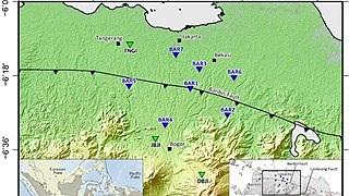
The Baribis Fault is a geological feature located in the northern part of Java. This fault, estimated to be 100 kilometers long, stretches from Purwakarta to Lebak Regency and is a threat to the Jakarta metropolitan area because the fault is partially located within the metropolitan area itself.

Danny Hilman Natawidjaja is an Indonesian geologist specializing in earthquake geology and geotectonics at the Indonesian Institute of Sciences (LIPI) Research Center for Geotechnology.

On 21 November 2022, at 13:21 WIB (UTC+07:00), a Mww 5.6 earthquake struck near Cianjur in West Java, Indonesia. The strike-slip earthquake occurred with a focal depth of 11 km (6.8 mi). Between 335 and 635 people died, 7,729 were injured and five remain missing. More than 62,628 homes were damaged across 16 districts in Cianjur Regency and the surrounding region. It is the deadliest earthquake to affect Indonesia since the 2018 Sulawesi earthquake. Damage evaluated after the event earned it a maximum Modified Mercalli intensity of VIII (Severe).
An earthquake affected the island of Java, Indonesia on 22 January 1780. The source and magnitude of the earthquake remains debated among seismologists. Proposed origins of the earthquake include shallow inland back-arc thrusting along a fault located within the upper crust on the island or rupture of the subduction zone off the southern coast of Java. The magnitude of the earthquake is estimated to be at least 8.5, while other sources usually refer to it with a range of Mw 8.0 to 8.5 for the megathrust earthquake. For the shallow crustal earthquake source, the magnitude range is Mw 7.0 to 8.0.
The Citarik Fault is a strike-slip fault that cuts across Western Java, Indonesia, passing through Pelabuhan Ratu, Bogor and Bekasi. It is a long crack in the earth's crust where two tectonic plates move past each other. The fault has been active since the Middle Miocene period, about 15 million years ago.
On 18 September 2024, at 09:41:06 WIB, a Mw 5.0 earthquake struck Bandung Regency in West Java, Indonesia, 14 km (8.7 mi) east-southeast of Banjar.