City of David (Silwan)

Last updated
The village boundary of Silwan in 1943-1946 is outlined in green. The boundary of Silwan in 2020 according to the Israeli municipal plan of Jerusalem is outlined in blue. SilwanBoundaries.jpg
The village boundary of Silwan in 1943–1946 is outlined in green. The boundary of Silwan in 2020 according to the Israeli municipal plan of Jerusalem is outlined in blue.

City of David (Silwan) is the Wadi Hilweh area of the Palestinian Arab village of Silwan, intertwined with an Israeli settlement. [1] [2] [3] The Silwan area of East Jerusalem was annexed by Israel following the 1967 Six-Day War and 1980 Jerusalem Law, an action not recognized internationally. The international community regards Israeli settlements as illegal under international law, although Israel disputes this.

Contents

The "City of David", or the Palestinian village of Wadi Hilweh, shown from the air in 2013 City of David, Wadi Hilweh - Palestinian village, Israeli settlement, Archaeological site - from the air.jpg
The "City of David", or the Palestinian village of Wadi Hilweh, shown from the air in 2013

The Wadi Hilweh neighborhood stretches over historical Jerusalem's so-called Southeast Hill, [lower-alpha 1] extending down from the southern city walls of the Old City. According to tradition, Silwan originated at the time of Saladin in the twelfth century on Ras al-Amud,[ clarification needed ] on the southwest slope of the Mount of Olives, then in the early twentieth century[ dubious ] it expanded across the Kidron Valley (known to locals as Wadi Sitti Maryam or the Valley of St. Mary), eventually incorporating all of the Southeast Hill. [5]

Modern history

Late Ottoman period

Illes Relief at the Tower of David Museum 06.jpg
c.1870 (Illés Relief)
VIEW OF JERUSALEM FROM THE HILL OF OPHEL (PRESENT DAY CITY OF DAVID SITE). (COUTESY OF AMERICAN COLONY). nvp SHl yrvSHlym.D826-042 (cropped).jpg
1910
Aerial view of the Temple Mount and City of David.JPG
1931
The development of the City of David / Wadi Hilweh area 1870-1931. A few small buildings can be seen on the hill facing the houses of Silwan in 1870; further houses were constructed in the following decades
UN map showing the City of David area as a series of Israeli "Inner Settlements" - each represented as red crosses - around "Beit Hazofe" (byt hTSvph, "Observation House"), and adjacent to Silwan and Ma'ale HaZeitim. UN map of Israeli Inner Settlement Ring around Jerusalem.jpg
UN map showing the City of David area as a series of Israeli "Inner Settlements" – each represented as red crosses – around "Beit Hazofe" (בית הצופה, "Observation House"), and adjacent to Silwan and Ma'ale HaZeitim.

The area immediately outside the walls of Jerusalem was undeveloped for most of early modern history, with the exception of the village of Silwan. Modern settlement outside of the walls began in the late 19th century. A few small buildings are visible on the hill facing the houses of Silwan in the Illés Relief, built between 1864 and 1873. In 1873–1874 a member of the notable Jewish Meyuchas family moved to a house on the towards the bottom of the hill. [6] [ dubious ] During the early 20th century, Baron de Rothschild acquired some land in the same area for the purposes of archaeological excavation. [7] The Meyuchas family left in the 1930s; no other Jewish families are known to have settled in the area during the period. [7]

Settlement in Mandatory Palestine

During the later stages of the Mandate era the houses of the nearby Arab village of Silwan expanded across the Kidron Valley and up the ridge of what became Wadi Hilweh.[ citation needed ]

Jordanian period

After the 1948 Arab–Israeli War, the whole area fell on the eastern side of the Green Line under Jordanian control.[ citation needed ]

Post 1967 and Israeli settlement

Arab families continued to live on the ridge and to build houses there after 1967.[ citation needed ]

More recently, the Wadi Hilweh neighbourhood has become the scene of both archaeological exploration and Israeli settler activity, becoming embroiled in what archaeologist Rafi Greenberg has called "the Israeli national project of unifying Jerusalem and the settler project of breaking Palestinian Jerusalem apart", both of which have "joined to disenfranchise the people living above and among the antiquities". [8]

Greenberg noted that, as of 2014, the local settlers were "a tiny, belligerent minority in Silwan", while the "indigenous [Palestinian] community are deprived of their materiality", calling it a "classic case of residual colonialism". [8]

In October 2014, Uri Ariel, politician from The Jewish Home party and at that time Israeli Minister of Housing and Construction, caused controversy when he suggested he was considering taking up residence in the area. [9]

Archaeological excavations

From 1968 to 1977 the Israel Exploration Society began the first excavations on the hill that rises to the north of the Wadi Hilweh neighbourhood, believed to be the elevated area known as the ophel of Jerusalem in the Hebrew bible. The work was led by Benjamin Mazar and Eilat Mazar. [10]

National Parks

The Jerusalem Walls [National] Park was declared in 1974 on "a large part of the neighborhood of Silwan." Other parks in East Jerusalem include Tzurim Valley Park in 2000 and in 2013, Mount Scopus Slopes National Park (located between al-'Esawiyah and a-Tur), and Refa’im Stream National Park (on lands belonging to al-Walaja). These parks were approved on privately owned Palestinian lands and in built-up areas or areas bordering the built-up sections of Palestinian neighborhoods and villages. According to B'Tselem these parks are not meant simply to protect nature, landscape and heritage but are also, "perhaps mainly", meant to promote political agendas. By declaring parts of the city as parks entails no development in these areas and serves the political agenda far better than any municipal restrictions on planning and building. [11]

In 1997, management of the City of David within the park was assumed by the Ir David Foundation (commonly known as Elad). First suggested in 1920 for this particular area, the term "City of David" was used officially from the 1970s onward, following the capture of East Jerusalem by Israel, but today the name with its biblical and political connotations is questioned by some in the archaeological academic community. [12] Since El'Ad took over the management of the park in 1997, 'David's City' has essentially become a religious-nationalist battle cry that has transformed the area from an ordinary Palestinian neighbourhood with a few excavation pits, largely unknown to the Israeli public, into a religious settlement and major national biblical monument with hundreds of thousands of visitors a year and an official education site for Israeli school children and soldiers.

Around 70 homes in the Al-Bustan area of Silwan are under threat of demolition. According to Ir Amim plans call for the establishment of a touristic and archeological park (King's Garden) which would extend the City of David southwards to cover the entirety of Al-Bustan and towards the settler enclave in central Silwan (Batan al-Hawa) where the Ateret Cohanim settler organization is active. [13]

After having been run by Elad for three years, management of the Jerusalem Archaeological Park/Davidson Center, south of the Western Wall Plaza, with effect from July 2021, reverted to the government’s Company for the Reconstruction and Development of the Jewish Quarter. [14]

Development projects

A US$60–66 million project to construct a 1.4 km cable-car running from the First Station compound, passing over the neighborhoods of Abu Tor and the Valley of Hinnom, then through the Mount Zion parking lot and ending at the Kedem visitor center in Silwan/City of David was put on hold following a judgement by the Israeli High Court on 24 February 2021. Since 2019, the court has several times examined petitions against the project, which is closely connected with Elad. Israeli authorities were given until 22 April to provide explanations to the Court on various matters. [15] [16]

Elad is planning the construction of a 16,000 m2 structure on the opposite side of the Wadi Hilweh Street, at the former Givati parking lot, the "Kedem Compound", which was approved in April 2014, [17] a project that was denounced by UNESCO in October 2016. [18]

Related Research Articles

Jerusalem Holy city of the Abrahamic religions located in Western Asia

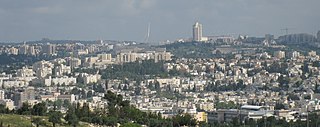
Jerusalem is a city in Western Asia. Situated on a plateau in the Judaean Mountains between the Mediterranean and the Dead Sea, it is one of the oldest cities in the world, and is considered holy for the three major Abrahamic religions: Judaism, Christianity, and Islam. The city straddles the Green Line between Israel and the West Bank; both Israelis and Palestinians claim Jerusalem as their capital. Israel controls the entire city and maintains its primary governmental institutions there while the Palestinian National Authority and Palestine Liberation Organization ultimately foresee it as the seat of power for the State of Palestine. Due to this long-running dispute, neither claim is widely recognized internationally.

City of David (archaeological site) Israeli settlement and archaeological site in East Jerusalem

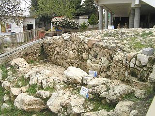
The City of David is the name given to an archaeological site on the southeast hill of contemporary East Jerusalem, which is thought to constitute the original settlement core of Jerusalem during the Bronze Age and Iron Ages.

Old City (Jerusalem) Walled area in East Jerusalem

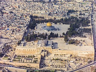
The Old City is a 0.9-square-kilometre (0.35 sq mi) walled area in East Jerusalem, part of the territory considered to be occupied by Israel by the international community.

History of Jerusalem Historical development of the city of Jerusalem

During its long history, Jerusalem has been attacked 52 times, captured and recaptured 44 times, besieged 23 times, and destroyed twice. The oldest part of the city was settled in the 4th millennium BCE, making Jerusalem one of the oldest cities in the world.

Ir Amim(Hebrew: עיר עמים; "City of Peoples" or "City of Nations") is an Israeli activist non-profit founded in 2004 that focuses on the Israeli-Palestinian conflict in Jerusalem. It seeks to ensure the "dignity and welfare of all its residents and that safeguards their holy places, as well as their historical and cultural heritages."

Tel Rumeida Archeological, agricultural and residential area in Hebron

Tel Rumeida, also known as Jabla al-Rahama and referred to by Israeli settlers as Tel Hebron is an archaeological, agricultural and residential area in the West Bank city of Hebron. Within it, lies a tell whose remains go back to the Chalcolithic period, and is thought to constitute the Canaanite, Israelite and Edomite settlements of Hebron mentioned in the Hebrew Bible.

Silwan Palestinian neighborhood in East Jerusalem

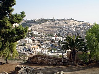
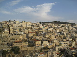
Silwan or Siloam is a predominantly Palestinian neighborhood in East Jerusalem, on the outskirts of the Old City of Jerusalem.

<i>Ophel</i> Biblical Hebrew term for urban elevation

Ophel, also Graecised to ophlas, is the biblical term given to a certain part of a settlement or city that is elevated from its surroundings, and probably means fortified hill or risen area. In the Hebrew Bible, the term is used in reference to two cities: Jerusalem, as in the Book of Chronicles and Book of Nehemiah, and Samaria, mentioned in the Books of Kings. The Mesha Stele, written in Moabite, a Canaanite language closely related to Biblical Hebrew, is the only extra-biblical source using the word, also in connection to a fortified place.

Judaization of Jerusalem Israeli attempts to transform Jerusalem to enhance its Jewish character

Judaization of Jerusalem is the view that Israel has sought to transform the physical and demographic landscape of Jerusalem to enhance its Jewish character at the expense of its Muslim and Christian ones. This also often involves the increasing Jewish presence in Jerusalem in the modern era, referring to the Jewish Old Yishuv becoming increasingly dominant since the Ottoman era; this process continued until it became the largest ethno-religious group in Jerusalem since the mid-19th century and until the 1948 War, when Jordan cleansed Eastern Jerusalem from its Jewish presence.

Ras al-Amud Neighborhood in East Jerusalem

Ras al-Amud is a Palestinian neighborhood in East Jerusalem, located southeast of the Old City of Jerusalem, overlooking the Palestinian neighborhoods of Silwan to the south and Abu Dis and al-Eizariya to the east, and bordering the Jewish neighborhood of Ma'ale HaZeitim to the north, which overlooks the Temple Mount. There were about 11,922 Arabs living in the neighborhood in 2003.

In 2009, clashes between Muslim Palestinians and Israeli police erupted on September 27, 2009 and continued to late October. Violence spread through East Jerusalem and parts of the West Bank, and included throwing of Molotov cocktails and stones at Israeli security forces and civilians. Israeli police responded with arrests of rioters and sporadic age-based restriction of access to the Temple Mount. Several dozen rioters, police and Israeli civilians have been injured.

Ir David Foundation

Ir David Foundation, commonly known as Elad [El'ad] is a Jerusalem-based, Israeli settler association which aims to strengthen the Jewish connection to Jerusalem, and renew the Jewish community in the City of David, which is also part of the neighborhood of Silwan. The foundation works to achieve its goals by tourism, education, archaeological excavations and obtaining homes in the area to establish a Jewish presence.

The King's Garden, known in Arabic: البستان as Al-Bustan, is a well-watered area south of the Temple Mount and the Wadi Hilweh/City of David neighbourhood in East Jerusalem. It is known under the name 'King's Garden' from the Hebrew Bible.

Wadi Qana Wadi in the West Bank and Israel

Wadi Qana, also known as Nahal Qana, is a wadi, with an intermittent stream meandering westwards from Huwara south of Nablus in the West Bank down to Jaljulia in Israel where it flows into the Yarkon River, of which it is a tributary.

Batn Al-Hawa is a residential neighborhood inside the village of Silwan, which is located south of the Al-Aqsa Mosque, outside the walls of the Old City of Jerusalem. The neighborhood or Mount Batn al-Hawa, which is an extension of the Mount of Olives, and is located in the eastern corner of Jerusalem; It is separated from it by the Silwan Valley, which connects to the Kidron Valley at the same point, and is known by the Jews as "Har Hashishit" or "The Flood Mountain.

Palestinian displacement in East Jerusalem East Jerusalem demographic engineering

Palestinian displacement in East Jerusalem is the transfer of Palestinian residents from the city due to Israeli policies aimed at an Israeli-Jewish demographic majority. Many Palestinian families in East Jerusalem have been affected by "forced relocation processes or been involved in lengthy legal procedures to revoke an eviction order." According to OCHA, between a third to a half of East Jerusalem's houses do not have permits, potentially placing over 100,000 Palestinian residents of the city at risk of forced displacement and forcible transfer as a result of demolitions.

The King's Garden (Silwan) known in Arabic: البستان as Al-Bustan is a well-watered area south of the Wadi Hilweh neighbourhood in East Jerusalem. Al-Bustan is a neighbourhood of the extended Arab village of Silwan, and consists of something over 100 houses.

"City of David" is a religious epithet for the ancient city of Jerusalem.

References

Notes

  1. "The Southeast Hill is the most excavated place in Jerusalem, with a history of more than 150 years of exploration." [4]

Citations

  1. Wendy Pullan and Max Gwiazda, Jerusalem's 'City of David': The Politicisation of Urban Heritage Archived 2017-08-09 at the Wayback Machine , Divided Cities/Contested States Working Paper No. 6, 2008, p.12: "The 'City of David' is formally treated as a settlement; making homes for Jewish people is seen as an integral part of El-Ad's heritage stewardship"
  2. The Independent , "Israeli foreign ministry cadets to defend 'legality' of West Bank settlements", 1 November 2015, "Among the new sessions to be added to the cadet's course are a lecture on the legality of the settlements based on the claim that the West Bank is not occupied territory, according to The Times of Israel. It also includes a tour of the “City of David” settlement in the Palestinian Silwan neighbourhood of East Jerusalem, to be led by settler leader David Be'eri, who seeks its transformation, based on biblical claims, into a Jewish area."
  3. Sixty-ninth session of the United Nations General Assembly, Israeli settlements in the Occupied Palestinian Territory, including East Jerusalem, and the occupied Syrian Golan: Report by the Secretary-General, A/69/348, 25 August 2014: "Archaeological excavations and parks are also used as a way to control land for settlements, mainly through the funding, participation and endorsement by the Government of Israel of archaeological projects led by settler organizations. Observer organizations report that several archaeological projects in the Old City of Jerusalem are being used as a means to consolidate the presence of settlements and settlers in the area. On 3 April 2014, despite several objections presented by Palestinian residents of the Silwan neighbourhood, a Palestinian community with a population of 45,000, located around the southern Old City wall in East Jerusalem, the Jerusalem District Planning and Building Committee approved a project known as the Kedem Compound.36 The Kedem Compound includes a museum, a visitors centre, and a parking lot covering around 16,000 square metres. The plan was presented by Israel's Nature and Parks Authority and the Ir David Foundation, also known as Elad, which works to strengthen the Jewish connection to Jerusalem, notably the Silwan area. The Kedem Compound would constitute a gateway to the City of David National Park, a touristic archaeological site controlled by the same organization."
  4. Galor 2017, p. 120.
  5. Galor 2017, p. 119.
  6. Yemin Moshe: The Story of a Jerusalem Neighborhood, Eliezer David Jaffe, Praeger, 1988, p. 51
  7. 1 2 Meron Rapoport, 2009, Ir Amin: "At the beginning of the 20th century, Baron de Rothschild acquired land on the eastern slopes of the Wadi Hilweh hill with the intention of dedicating it to archaeological excavations... As far as we know, during this period, only a single Jewish family lived in Wadi Hilweh itself, in a house known today as the "Meyuhas house," and left during the 1930s."
  8. 1 2 Greenberg 2014, pp. 29.
  9. Housing Minister Uri Ariel May Move to City of David, 25 October 2014.
  10. Excavations on the South of the Temple Mount. The Ophel of Biblical Jerusalem, Qedem. Monographs of the Institute of Archaeology, The Hebrew University of Jerusalem, No. 29, 1989 ISSN 0333-5844
  11. "National parks as tool for constraining Palestinian neighborhoods in East Jerusalem". 16 September 2014. Retrieved 25 July 2021.
  12. Wendy Pullan; Maximilian Sternberg; Lefkos Kyriacou; Craig Larkin; Michael Dumper (20 November 2013). "David's City in Palestinian Silwan". The Struggle for Jerusalem's Holy Places. Routledge. pp. 76–77. ISBN   978-1-317-97556-4..
  13. "Reignited Plan For "King's Garden" Park Threatens To Displace Over 1000 Palestinians From Al Bustan, Silwan". 25 March 2021. Retrieved 25 July 2021.
  14. "Settler group loses control over Jerusalem archaeological park". Haaretz.
  15. "First court victory for opponents of Jerusalem cable car project - Al-Monitor: The Pulse of the Middle East". www.al-monitor.com.
  16. "Settlement & Annexation Report: February 25, 2021". Foundation for Middle East Peace.
  17. Sixty-ninth session of the United Nations General Assembly, Israeli settlements in the Occupied Palestinian Territory, including East Jerusalem, and the occupied Syrian Golan: Report by the Secretary-General, A/69/348, 25 August 2014: "On 3 April 2014, despite several objections presented by Palestinian residents of the Silwan neighbourhood, a Palestinian community with a population of 45,000, located around the southern Old City wall in East Jerusalem, the Jerusalem District Planning and Building Committee approved a project known as the Kedem Compound. The Kedem Compound includes a museum, a visitors centre, and a parking lot covering around 16,000 square metres. The plan was presented by Israel's Nature and Parks Authority and the Ir David Foundation, also known as Elad, which works to strengthen the Jewish connection to Jerusalem, notably the Silwan area. The Kedem Compound would constitute a gateway to the City of David National Park, a touristic archaeological site controlled by the same organization. Furthermore, Elad presented plans, covering an estimated area of 1,200 square metres for the construction of another tourist compound above a site known as the spring house in Silwan, an ancient structure built above the main spring. Palestinians in the area have been prevented from accessing one of their main sources of water, since Elad has blocked the entrance to the spring by walls and fences. According to the Ir Amim archaeological organization, the plan was submitted for objections in February 2014. According to Emek Shaveh, an organization of archaeologists, an examination of the placement of the excavations and the planned tourist centres (the Kedem Compound, the City of David Visitors Centre, and the Spring House tourist centre) shows that a contiguous line of Israeli settler presence along the entire northern boundary of the Silwan area is being created."
  18. 200 EX/PX/DR.25.2 Rev. PARIS, 12 October 2016: "The Executive Board... Deplores the Israeli decision to approve... the construction of the so-called “Kedem Center”, a visitor centre near the southern wall of the Al-Aqṣa Mosque/Al-Ḥaram Al-Sharif... and urges Israel, the occupying Power, to renounce the above-mentioned projects and to stop the construction works in conformity with its obligations under the relevant UNESCO conventions, resolutions and decisions"

Sources

Further reading

Coordinates: 31°46′25″N35°14′08″E / 31.77361°N 35.23556°E / 31.77361; 35.23556