The site flourished from about the 6th century B.C. through the 1st century C.E., during the Preclassic Period (see: Mesoamerican chronology). It may have had a peak population of some 10,000 people.
The site is about 25 miles (40km) east of Tikal, on a ridge over the left bank of the Holmul river.
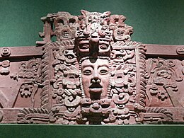
The site has temples on step pyramids and plazas arranged to point to astronomical events such as the equinoxsunrise, and is surrounded by a defensive wall. The site's largest step pyramid is 27 metres high and 70 x 40 metres wide. Some buildings were decorated with stucco sculptures depicting Mesoamericandeities.
The site was long lost in the jungle, and was discovered and partly plundered by looters around 1980. It was first mapped by explorerIan Graham in 1984, who gave it the name Cival after a local word for "lagoon". The ancient name of the site is currently unknown.
Investigations at Cival have added to knowledge of the Pre-Classic Maya, including revealing the earliest inscriptions with Maya calendar dates and showing dynastic succession of monarchs.
Some news reports have incorrectly stated that Pre-Classic Maya cities were previously unknown. Pre-Classic buildings in the Peten have been excavated by archaeologists since the work at Uaxactun in the 1920s, and the major breakthrough which revealed that the Pre-Classic Maya were more highly developed and urbanized in this era than had long been thought was the archaeological project at El Mirador starting in the late 1970s.
Tayasal is a Maya archaeological site located in present-day Guatemala. It was a large Maya city with a long history of occupation. Tayasal is a corruption of Tah Itza, a term originally used to refer to the core of the Itza territory in Petén. The name Tayasal was applied in error to the archaeological site, and originally applied to the Itza capital. However, the name now refers to the peninsula supporting both the archaeological site and the village of San Miguel. The site was occupied from the Middle Preclassic period through to the Late Postclassic (c. 1200–1539 AD).
El Mirador is a large pre-Columbian Middle and Late Preclassic Maya settlement, located in the north of the modern department of El Petén, Guatemala. It is part of the Mirador-Calakmul Karst Basin of northern Guatemala.
Motul de San José is an ancient Maya site located just north of Lake Petén Itzá in the Petén Basin region of the southern Maya lowlands. It is a few kilometres from the modern village of San José, in Guatemala's northern department of Petén. A medium-sized civic-ceremonial centre, it was an important political and economic centre during the Late Classic period (AD 650–950).
The Petén Basin is a geographical subregion of the Maya Lowlands, primarily located in northern Guatemala within the Department of El Petén, and into the state of Campeche in southeastern Mexico.
Ixlu is a small Maya archaeological site that dates to the Classic and Postclassic Periods. It is located on the isthmus between the Petén Itzá and Salpetén lakes, in the northern Petén Department of Guatemala. The site was an important port with access to Lake Petén Itzá via the Ixlu River. The site has been identified as Saklamakhal, also spelt Saclemacal, a capital of the Kowoj Maya.
Tres Islas is a small pre-Columbian Maya archaeological site 20 kilometres (12 mi) north of Cancuen in Petén Department, northern Guatemala. The site has been dated to the Late Preclassic and Late Classic periods of Mesoamerican chronology. The main feature of the site is a group of three Maya stelae and an altar, arranged in a way that mimics an E-Group Maya astronomical complex.
Ixtutz was an important Classic Period Maya city located south of Ixkun in southeastern Petén, Guatemala. Ixtutz is situated in the valley of the Poxte River in the western portion of the Maya Mountains. The site was inhabited during the Preclassic Period to the end of the Terminal Classic Period of Mesoamerican chronology and dominated the western portion of the Dolores valley.
Zacpeten is a pre-Columbian Maya archaeological site in the northern Petén Department of Guatemala. It is notable as one of the few Maya communities that maintained their independence through the early phases of Spanish control over Mesoamerica.
El Zotz is a Mesoamerican archaeological site of the pre-Columbian Maya civilization, located in the Petén Basin region around 20 kilometres (12 mi) west of the major center of Tikal and approximately 26 kilometres (16 mi) west of Uaxactun. It is so called because of the large number of bats living in caves in the nearby cliffs. The site is located within the San Miguel la Palotada National Park bordering the Tikal National Park in the present-day department of Petén, Guatemala. It is a large Classic Period site and contains many unexcavated mounds and ruins.
Witzna is a mid-sized archaeological site of the pre-Columbian Maya civilization, situated in the Petén Basin region of what is now northern Guatemala. Inscriptions discovered on site indicate that the city was known to the ancient Mayans as Bahlam Jol. Significant occupancy is dated to the Classic period of Mesoamerican chronology. It is located near the confluence of the Holmul and Ixcán Rivers, near the site of Chanchich II.
Yaxha is a Mesoamerican archaeological site in the northeast of the Petén Basin in modern-day Guatemala. As a ceremonial centre of the pre-Columbian Maya civilization, Yaxha was the third largest city in the region and experienced its maximum power during the Early Classic period.
Nakum is a Mesoamerican archaeological site, and a former ceremonial center and city of the pre-Columbian Maya civilization. It is located in the northeastern portion of the Petén Basin region, in the modern-day Guatemalan department of Petén. The northeastern Petén region contains a good number of other significant Maya sites, and Nakum is one of the three sites forming the Cultural Triangle of "Yaxha-Nakum-Naranjo". Nakum is approximately 17 kilometres (10.6 mi) to the north of Yaxha and some 25 kilometres (15.5 mi) to the east of Tikal, on the banks of the Holmul River. Its main features include an abundance of visibly restored architecture, and the roof comb of the site's main temple structure is one of the best-preserved outside Tikal.
La Sufricaya is an archaeological site of the pre-Columbian Maya civilization, located in the Petén Basin region of present-day Guatemala. The site is situated approximately 1.2 km (0.75 mi) west of the site of Holmul, and the relationship between these two sites during the Classic period occupations is a main focus of ongoing investigations.
El Tintal is a Maya archaeological site in the northern Petén region of Guatemala, about 25 kilometres (16 mi) northeast of the modern-day settlement of Carmelita, with settlement dating to the Preclassic and Classic periods. It is close to the better known sites of El Mirador, to which it was linked by causeway, and Nakbé. El Tintal is a sizeable site that includes some very large structures and it is one of the four largest sites in the northern Petén; it is the second largest site in the Mirador Basin, after El Mirador itself. El Tintal features monumental architecture dating to the Middle Preclassic similar to that found at El Mirador, Nakbé and Wakna. Potsherds recovered from the site date to the Late Preclassic and Early Classic periods, and construction continued at the site in the Late Classic period.
Holmul is a pre-Columbian archaeological site of the Maya civilization located in the northeastern Petén Basin region in Guatemala near the modern-day border with Belize.
Punta de Chimino is a Maya archaeological site in the Petexbatún region of the department of Petén in Guatemala. Occupation at the site dates to the Preclassic and Classic periods of Mesoamerican chronology. Punta de Chimino experienced a population surge in the Late Preclassic, followed by a reduction in occupation levels in the Early Classic and another increase in the Terminal Classic when the city became one of the few population centres to survive the political disintegration of the Petexbatún region after the collapse of the kingdom based at Dos Pilas. The neighbouring city of Seibal on the Pasión River appears to have intervened at Punta de Chimino at this time and to have politically dominated the smaller site.
The Preclassic period in Maya history stretches from the beginning of permanent village life c. 1000 BC until the advent of the Classic Period c. 250 AD, and is subdivided into Early, Middle, and Late. Major archaeological sites of this period include Nakbe, Uaxactun, Seibal, San Bartolo, Cival, and El Mirador.
Nojpetén was the capital city of the Itza Maya kingdom of Petén Itzá. It was located on an island in Lake Petén Itzá in the modern department of Petén in northern Guatemala. The island is now occupied by the modern town of Flores, the capital of the Petén department, and has had uninterrupted occupation since pre-Columbian times. Nojpetén had defensive walls built upon the low ground of the island, which may have been hastily constructed by the Itza at a time when they felt threatened either by the encroaching Spanish or by other Maya groups.
Kʼo is one of several Mayan ceremonial center sites around and associated with the Classic Mayan city of Holmul located in modern-day Guatemala. Currently, the site boasts what may be the royal tomb of the earliest known Mayan ruler.
This page is based on this Wikipedia article Text is available under the CC BY-SA 4.0 license; additional terms may apply. Images, videos and audio are available under their respective licenses.