The Spanish conquest of Yucatán was the campaign undertaken by the Spanish conquistadores against the Late Postclassic Maya states and polities in the Yucatán Peninsula, a vast limestone plain covering south-eastern Mexico, northern Guatemala, and all of Belize. The Spanish conquest of the Yucatán Peninsula was hindered by its politically fragmented state. The Spanish engaged in a strategy of concentrating native populations in newly founded colonial towns. Native resistance to the new nucleated settlements took the form of the flight into inaccessible regions such as the forest or joining neighbouring Maya groups that had not yet submitted to the Spanish. Among the Maya, ambush was a favoured tactic. Spanish weaponry included broadswords, rapiers, lances, pikes, halberds, crossbows, matchlocks, and light artillery. Maya warriors fought with flint-tipped spears, bows and arrows and stones, and wore padded cotton armour to protect themselves. The Spanish introduced a number of Old World diseases previously unknown in the Americas, initiating devastating plagues that swept through the native populations.
Petén is a department of Guatemala. It is geographically the northernmost department of Guatemala, as well as the largest by area – at 35,854 km2 (13,843 sq mi) it accounts for about one third of Guatemala's area. The capital is Flores. The population at the mid-2018 official estimate was 595,548.
Tayasal is a Maya archaeological site located in present-day Guatemala. It was a large Maya city with a long history of occupation. Tayasal is a corruption of Tah Itza, a term originally used to refer to the core of the Itza territory in Petén. The name Tayasal was applied in error to the archaeological site, and originally applied to the Itza capital. However, the name now refers to the peninsula supporting both the archaeological site and the village of San Miguel. The site was occupied from the Middle Preclassic period through to the Late Postclassic (c. 1200–1539 AD).

Mesoamerican chronology divides the history of prehispanic Mesoamerica into several periods: the Paleo-Indian ; the Archaic, the Preclassic or Formative (2500 BCE – 250 CE), the Classic (250–900 CE), and the Postclassic (900–1521 CE); as well as the post European contact Colonial Period (1521–1821), and Postcolonial, or the period after independence from Spain (1821–present).

Naranjo is a Pre-Columbian Maya city in the Petén Basin region of Guatemala. It was occupied from about 500 BC to 950 AD, with its height in the Late Classic Period. The site is part of Yaxha-Nakum-Naranjo National Park. The city lies along the Mopan and Holmul rivers, and is about 50 km east of the site of Tikal. Naranjo has been the victim of severe looting. The site is known for its polychrome ceramic style.

The Itza are a Maya ethnic group native to the Péten region of northern Guatemala and parts of Belize. The majority of Itza are inhabitants of the city of Flores on Lake Petén Itzá, and nearby portions of Belize where they form an ethnic minority.

Trade was a crucial factor in maintaining Maya cities.
Ixlu is a small Maya archaeological site that dates to the Classic and Postclassic Periods. It is located on the isthmus between the Petén Itzá and Salpetén lakes, in the northern Petén Department of Guatemala. The site was an important port with access to Lake Petén Itzá via the Ixlu River. The site has been identified as Saklamakhal, also spelt Saclemacal, a capital of the Kowoj Maya.

Topoxte is a pre-Columbian Maya archaeological site in the Petén Basin in northern Guatemala with a long occupational history dating as far back as the Middle Preclassic. As the capital of the Kowoj Maya, it was the largest of the few Postclassic Mesoamerican sites in the area. Topoxte is located on an island on Yaxha Lake across from the important Classic period center of Yaxha.

Yaxha is a Mesoamerican archaeological site in the northeast of the Petén Basin in modern-day Guatemala. As a ceremonial centre of the pre-Columbian Maya civilization, Yaxha was the third largest city in the region and experienced its maximum power during the Early Classic period.

Nakum is a Mesoamerican archaeological site, and a former ceremonial center and city of the pre-Columbian Maya civilization. It is located in the northeastern portion of the Petén Basin region, in the modern-day Guatemalan department of Petén. The northeastern Petén region contains a good number of other significant Maya sites, and Nakum is one of the three sites forming the Cultural Triangle of "Yaxha-Nakum-Naranjo". Nakum is approximately 17 kilometres (10.6 mi) to the north of Yaxha and some 25 kilometres (15.5 mi) to the east of Tikal, on the banks of the Holmul River. Its main features include an abundance of visibly restored architecture, and the roof comb of the site's main temple structure is one of the best-preserved outside Tikal.

The Mirador Basin is a hypothesized geological depression found in the remote rainforest of the northern department of Petén, Guatemala. Mirador Basin consists of two true basins, consisting of shallowly sloping terrain dominated by low-lying swamps called bajos; one draining into the San Pedro River and the other into the Candelaria River. The basin is surrounded by rugged karstic limestone hills on the east and south, forming a triangular geographical "trough" covering more than 2,169 km2 (837 sq mi). The geological formation of the landscape, as well as the significance of the formation, are the subject of some controversy in Northern Guatemala. NASA Shuttle Radar Topography Mission (SRTM) data indicate no depression in the area.
La Sufricaya is an archaeological site of the pre-Columbian Maya civilization, located in the Petén Basin region of present-day Guatemala. The site is situated approximately 1.2 km (0.75 mi) west of the site of Holmul, and the relationship between these two sites during the Classic period occupations is a main focus of ongoing investigations.

El Tintal is a Maya archaeological site in the northern Petén region of Guatemala, about 25 kilometres (16 mi) northeast of the modern-day settlement of Carmelita, with settlement dating to the Preclassic and Classic periods. It is close to the better known sites of El Mirador, to which it was linked by causeway, and Nakbé. El Tintal is a sizeable site that includes some very large structures and it is one of the four largest sites in the northern Petén; it is the second largest site in the Mirador Basin, after El Mirador itself. El Tintal features monumental architecture dating to the Middle Preclassic similar to that found at El Mirador, Nakbé and Wakna. Potsherds recovered from the site date to the Late Preclassic and Early Classic periods, and construction continued at the site in the Late Classic period.
Holmul is a pre-Columbian archaeological site of the Maya civilization located in the northeastern Petén Basin region in Guatemala near the modern-day border with Belize.
The Holmul River is a river in northeastern Guatemala that flows through the Petén Basin region in the departamento (department) of El Petén towards the border with Belize. A number of significant pre-Columbian Maya sites lie along or near the course of this waterway, including Tikal, Nakum, Holmul, Naranjo, Yaxha and Witzna.

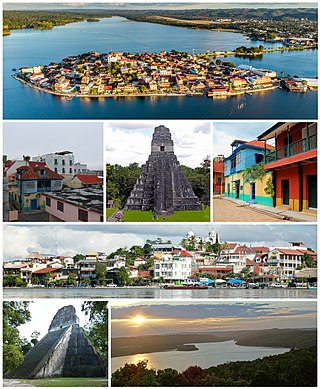
Nojpetén was the capital city of the Itza Maya kingdom of Petén Itzá. It was located on an island in Lake Petén Itzá in the modern department of Petén in northern Guatemala. The island is now occupied by the modern town of Flores, the capital of the Petén department, and has had uninterrupted occupation since pre-Columbian times. Nojpetén had defensive walls built upon the low ground of the island, which may have been hastily constructed by the Itza at a time when they felt threatened either by the encroaching Spanish or by other Maya groups.
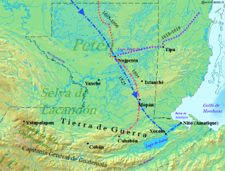
The Spanish conquest of Petén was the last stage of the conquest of Guatemala, a prolonged conflict during the Spanish colonisation of the Americas. A wide lowland plain covered with dense rainforest, Petén contains a central drainage basin with a series of lakes and areas of savannah. It is crossed by several ranges of low karstic hills and rises to the south as it nears the Guatemalan Highlands. The conquest of Petén, a region now incorporated into the modern republic of Guatemala, climaxed in 1697 with the capture of Nojpetén, the island capital of the Itza kingdom, by Martín de Ursúa y Arizmendi. With the defeat of the Itza, the last independent and unconquered native kingdom in the Americas fell to European colonisers.

The Kejache were a Maya people in northern Guatemala at the time of Spanish contact in the 17th century. The Kejache territory was located in the Petén Basin in a region that takes in parts of both Guatemala and Mexico. Linguistic evidence indicates that the Kejache shared a common origin with the neighbouring Itzas to their southeast and the Kejache may have occupied the general region since the Classic period. The Kejache were initially contacted by conquistador Hernán Cortés in 1525; they were later in prolonged contact with the Spanish as the latter opened a route southwards towards Lake Petén Itzá.
The history of Maya civilization is divided into three principal periods: the Preclassic, Classic and Postclassic periods; these were preceded by the Archaic Period, which saw the first settled villages and early developments in agriculture. Modern scholars regard these periods as arbitrary divisions of chronology of the Maya civilization, rather than indicative of cultural evolution or decadence. Definitions of the start and end dates of period spans can vary by as much as a century, depending on the author. The Preclassic lasted from approximately 3000 BC to approximately 250 AD; this was followed by the Classic, from 250 AD to roughly 950 AD, then by the Postclassic, from 950 AD to the middle of the 16th century. Each period is further subdivided:


