Clairmont, New Mexico

Last updated
Clairmont
USA New Mexico location map.svg
Red pog.svg
Clairmont
Location within the state of New Mexico
Usa edcp location map.svg
Red pog.svg
Clairmont
Clairmont (the United States)
Coordinates: 33°26′41″N108°46′46″W / 33.44472°N 108.77944°W / 33.44472; -108.77944
Country United States
State New Mexico
County Catron
Population
 (2000)
  Total0
Time zone UTC-5 (Mountain (MST))
  Summer (DST)MDT
Area code 575

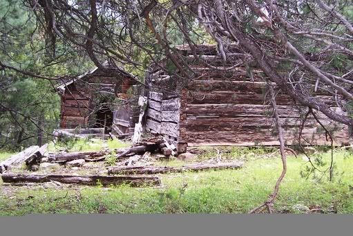
Clairmont is a ghost town located 19 miles northeast of Glenwood in Catron County, New Mexico, United States. [1]

Contents

History

As early as 1822 the site is reported to have been a mining camp, surviving through the 1880s as a supply center for prospectors. Located near Copper Creek, today there are old log cabins and a corral on the site. [2] In 1883 the town had a post office. [3] Clairmont is noted by historians as having been a significant mining community. [4]

Related Research Articles

<span class="mw-page-title-main">Leadville, Colorado</span> City in Colorado, United States

Leadville is a statutory city that is the county seat, the most populous community, and the only incorporated municipality in Lake County, Colorado, United States. The city population was 2,633 at the 2020 census. It is situated at an elevation of 10,158 feet (3,096 m). Leadville is the third highest incorporated city in the United States behind Alma and Montezuma and is surrounded by two of the tallest peaks in the state.

<span class="mw-page-title-main">Catron County, New Mexico</span> County in New Mexico, United States

Catron County is a county in the U.S. state of New Mexico. As of the 2020 census, the population was 3,579, making it New Mexico's third-least populous county. Its county seat is Reserve. Catron County is New Mexico's largest county by area.

<span class="mw-page-title-main">North Decatur, Georgia</span> CDP in Georgia, United States

North Decatur is a census-designated place (CDP) in DeKalb County, Georgia, United States. The population was 16,698 at the 2010 census.

<span class="mw-page-title-main">Keweenaw National Historical Park</span> U.S. national historical park in Michigan

Keweenaw National Historical Park is a unit of the U.S. National Park Service. Established in 1992, the park celebrates the life and history of the Keweenaw Peninsula in the Upper Peninsula of the U.S. state of Michigan. As of 2009, it is a partly privatized park made up of two primary units, the Calumet Unit and the Quincy Unit, and 21 cooperating "Heritage Sites" located on federal, state, and privately owned land in and around the Keweenaw Peninsula. The National Park Service owns approximately 1,700 acres (690 ha) in the Calumet and Quincy Units. Units are located in Baraga, Houghton, Keweenaw, and Ontonagon counties.

<span class="mw-page-title-main">Animas Forks, Colorado</span> Unincorporated in Colorado, United States

Animas Forks is an extinct mining town located 12 miles (19 km) northeast of Silverton in San Juan County, Colorado, United States. The area is managed by the Bureau of Land Management. At an elevation of 11,185 feet (3,409 m), Animas Forks is one of the highest mining camps in the North America.

Saratoga Springs, Nebraska Territory, or Saratoga, was a boom and bust town founded in 1856 that thrived for several years. During its short period of influence the town grew quickly, outpacing other local settlements in the area including Omaha and Florence, and briefly considered as a candidate for the Nebraska Territorial capitol. Saratoga was annexed into Omaha in 1887, and has been regarded a neighborhood in North Omaha since then.

<span class="mw-page-title-main">Culture of Omaha, Nebraska</span> Overview of the culture of Omaha, Nebraska (USA)

The culture of Omaha, Nebraska, has been partially defined by music and college sports, and by local cuisine and community theatre. The city has a long history of improving and expanding on its cultural offerings. In the 1920s, the Omaha Bee newspaper wrote, "The cultural future of Omaha seems as certain of greatness as the commercial future... The symphony orchestra, the Art institute, the Community Playhouse and other organizations are on firm foundations and Omaha is destined to be not only a bigger, but a better city, both financially and culturally." Reviewing Omaha's contemporary arts scene in 2007, the New York Times hailed the city as having "a kind of cultural awakening".

<span class="mw-page-title-main">Florence Mill (Omaha, Nebraska)</span> United States historic place

Florence Mill, also known as the Weber Mill, is a historic mill located at 9102 North 30th Street near the 30th Street exit on I-680 in the Florence community in North Omaha, Nebraska. It was built in 1846 and operated into the 1960s. It was listed on the National Register of Historic Places as Weber Mill in 1998. The mill is also known as the Mormon Mill, Grist Mill, and Old Pink Mill. It is now operated as the Winter Quarters Mill Museum and ArtLoft Gallery.

<span class="mw-page-title-main">Mogollon, New Mexico</span> Ghost town in New Mexico, United States

Mogollon, also called the Mogollon Historic District, is a former mining town located in the Mogollon Mountains in Catron County, New Mexico, United States. Located east of Glenwood and Alma, it was founded in the 1880s at the bottom of Silver Creek Canyon to support the gold and silver mines in the surrounding mountains. The "Little Fannie" mine became the most important employer for the town. During the 1890s, Mogollon had a transient population of between 3,000 and 6,000 miners. Because of its isolation, it had a reputation as one of the wildest mining towns in the West. Today Mogollon is listed as Fannie Hill Mill and Company Town Historic District on the National Register of Historic Places.

Alma is an unincorporated community and census-designated place in Catron County, New Mexico, United States, north of Glenwood and south of Reserve.

<span class="mw-page-title-main">Glenwood, New Mexico</span> Census-designated place in New Mexico, United States

Glenwood is a census-designated place in Catron County, New Mexico, United States. As of the 2010 census it had a population of 143. The area was founded in 1878 as Bush Ranch. Located near the San Francisco River, Glenwood is 61 miles (98 km) northwest of Silver City on U.S. Route 180, and is 38 miles (61 km) south of Reserve.

<span class="mw-page-title-main">San Francisco Plaza, New Mexico</span> Unincorporated community in New Mexico, United States

San Francisco Plaza was the name of three towns in Catron County, New Mexico, United States. Located in the San Francisco River Valley, the towns were settled by Spanish settlers in the 1860s. Today Middle San Francisco Plaza is called Middle Frisco, Lower San Francisco is called Lower Frisco, and Upper San Francisco was renamed Reserve when U.S. Forest Service headquarters were built there.

James C. Cooney was a sergeant of the U.S. Army in the 8th U.S. Cavalry when he found large silver and gold reserves in the Mogollon Mountains of Catron County, New Mexico. He was transferred to Fort Bayard, near Silver City, New Mexico in 1870. While scouting for the 8th U.S. Cavalry north of Mogollon and east of Alma, he discovered silver ore in the Mogollon Mountains. He began working the claim after leaving the Army in 1876.

Apache Creek is a census-designated place in Catron County, New Mexico, United States. As of the 2010 census it had a population of 67. Located 3 miles (5 km) northeast of Cruzville, it is situated at the confluence of Apache Creek and the Tularosa River. The Apache Creek Pueblo, also called the "Apache Creek Ruin", is near the town. It was listed by the New Mexico Historic Preservation Commission in 1969.

Cooney is a ghost town in Catron County, New Mexico, United States, east of Alma. Cooney was once home to gold and silver prospectors in the nearby Mogollon Mountains.

Red Hill is a ghost town in Catron County, New Mexico, United States, west of Quemado.

Courtland is a ghost town in Cochise County, Arizona, that was founded in 1909 due to a copper boom. The town is located at the foot of the Dragoon Mountains, about fifteen miles northeast of Tombstone, and was named after Courtland Young, one of the owners of the Great Western Mining Company.

Etta, also known as Etta Camp and Etta Mine, is a ghost town in Pennington County, South Dakota, United States. It was a successful mining town, known for its discovery of the largest spodumene crystal ever found.

Colorado City is now a ghost town, in Clark County, Nevada, located under Lake Mohave at the mouth of El Dorado Canyon.

References

  1. (nd) Glenwood Archived 2007-06-21 at the Wayback Machine . New Mexico Magazine. Retrieved 6/13/07.
  2. (nd) Clairmont. GhostTowns.com. Retrieved 6/13/07.
  3. U.S. Postal History continued... Archived 2007-09-28 at the Wayback Machine Siegal Auctions. Retrieved 6/13/07.
  4. (nd) History of Socorro County. USGenWeb. Retrieved 6/13/07.