Claybrooke Magna

Last updated

Claybrooke Magna
Bell View Court, Claybrooke Magna - geograph.org.uk - 626756.jpg
Bell View Court, Claybrooke Magna
Leicestershire UK location map.svg
Red pog.svg
Claybrooke Magna
Location within Leicestershire
Population613 (2011 Census)
OS grid reference SP4904688759
Civil parish
  • Claybrooke Magna
District
Shire county
Region
Country England
Sovereign state United Kingdom
Post town LUTTERWORTH
Postcode district LE17
Dialling code 01455
Police Leicestershire
Fire Leicestershire
Ambulance East Midlands
UK Parliament
List of places
UK
England
Leicestershire
52°29′39″N1°16′39″W / 52.494167°N 1.2775°W / 52.494167; -1.2775

Claybrooke Magna is a village and civil parish in the Harborough district of Leicestershire, England, close to the A5 trunk road. The village is located between junctions 20 and 21 of the M1, and the towns of Leicester, Rugby, Lutterworth and Market Harborough are easily accessible. [1]

Contents

History

The village's name means 'brook with clayey soil'. [2]

Claybrooke Magna with Claybrooke Parva were listed in the Domesday Book of 1086 as being within the wapentake of Guthlaxton, [3] which centuries later was referred to as a hundred. The manor was managed by a local lord named Fulco, who was subordinate to the tenant-in-chief, the wise and powerful Robert de Beaumont, 1st Earl of Leicester.

According to information sourced from the Vision of Britain in the 1870s, Claybrooke was described as:

"CLAYBROOKE, two townships in Lutterworth district, Leicester; and a parish partly also in Warwick. One of the townships bears the name of Great Claybrooke; lies near the junction of Watling-street and the Fosse way, 1 mile WSW of Ullesthorpe r. station, and 4 NW of Lutterworth; occupies high ground, commanding an extensive view; includes the site of the Roman station Vennonæ; and has a post office, of the name of Claybrooke, under Lutterworth. Pop., 424. Houses, 103. The other township bears the name of Little Claybrooke; and lies contiguous to Great Claybrooke. ..." [4]

The population and wealth of the region grew, leading locally to partition of the ancient parish of Claybrooke into the civil parish of Claybrook Magna and the adjoining civil parish of Claybrooke Parva in the late 1800s.

Claybrooke Magna has seven grade II listed buildings. Including the Claybrooke Mill House, Manor Farmhouse, Dairy Farmouse, Claybrooke Mill, Claybrooke Mill House, Ashleigh and the Dairy Farmhouse. [5] The Watermill dates from 1763 and was extended in 1840. It is stated that milling has taken place at the watermill for over 1000 years [6] and most of the mill machinery is still intact and the mill continues to be in commercial operation. [7] In 2014, Miller Sally Craven produces over 40 different varieties of flour at the Watermill. There is a varied product range and includes traditional flour types as well as unusual blends such as Chilli Flour Mix and Spicy Tomato Flour Mix which shows how the mill has diversified since its establishment in 1763. These products are sold and available from local outlets. [6]

The Dairy Farmhouse includes an early 17th-century stable which was altered in the late 17th century. It is thought that the stable was originally part of an agricultural complex. [8] It became a listed building on 30 September 1993. [9]

Claybrooke Magna Village Hall - geograph.org.uk - 134506 Claybrooke Magna - geograph.org.uk - 134506.jpg
Claybrooke Magna Village Hall - geograph.org.uk - 134506

Claybrooke Village Hall is a traditional Victorian building located along the main street, which has been modernised in recent years to offer facilities for social and sporting events within the local community. It can accommodate up to 100 people in the main hall and the Meeting Room has space for up to 30. [10]

In the 1960s new homes were built in Claybrooke on the site of the original woodyard [11] and listed buildings Claybrooke Mill and Claybrooke Hall were refurbished. Although local amenities diminished resulting in the village shop and post office closing. [12]

In 1972 Whitmores Timbers relocated their site in Bury St Edmunds to its current centrally located site within the village of Claybrooke Magna. [13] The remains of the chapel still remain in Claybrooke but serve the purpose of storing machinery from the woodyard. [14]

Claybrooke Magna has previously accommodated three pubs within the village, one of these being 'The Blue Bell' which was closed in the 1920s and had an alternate use as a bakehouse after closure. In 1986 it was recorded as being the private house of 'The White House' [11] but according to records has since been demolished. [15] 'The Royal Oak' was situated on the Main Road and was known as The Woodcutter at time of closure. Although, the village is currently home to a local pub called 'The Pig in Muck'. In July 2013, it opened its very own brewery to the general public. Allowing the general public to see how the beer is brewed. It is now brewing the Pig Pub Brewery cask conditioned beers which are all served within the pub and also at a sister pub located in Leicester City Centre. [16]

In 1997, TV actor Barry Evans was found dead at his home in Claybrooke Magna. A youth was charged with attempted murder but later released. The exact circumstances surrounding his death remain a mystery.

Demographics

Total population of Claybrooke Magna Civil parish, Leicestershire, as reported by the Census of Population from 1881 to 2011 Claybrooke Magna Population Time Series 1881-2011.jpg
Total population of Claybrooke Magna Civil parish, Leicestershire, as reported by the Census of Population from 1881 to 2011

According to the 2011 Census, Claybrooke Magna had a population of 613. There were also 222 households in the area. [17] The Topographical Dictionary of England was published in 1848 and details the population of Greater Claybrooke as 514 and Little Claybrooke as 104. [12]

Pie chart showing population of Claybrooke Magna in different industry sectors using census data Population of Claybrooke Magna in different industry sectors.png
Pie chart showing population of Claybrooke Magna in different industry sectors using census data

Historically in Claybrooke Magna, men were employed by the timber mill or worked on the land, but now few men who live within Claybrooke Magna are employed in this sort of primary and secondary employment. The 2001 census found that 26.7% of residents work within the extractive and manufacturing industries, whereas 73.3% work in the service industries. [19] This trend is concordant with the trend within England as it was found that in 2011, less than one in 100 people worked in agriculture in England and Wales. [20] In 2014, there is unemployment among younger members of Claybrooke Magna which could be attributed poor public transport facilities and a large majority of the working population commute to larger towns within the area such as Leicester or Coventry for work. [21]

Related Research Articles

<span class="mw-page-title-main">Leicestershire</span> County of England

Leicestershire is a ceremonial county in the East Midlands of England. It is bordered by Derbyshire, Nottinghamshire, and Lincolnshire to the north, Rutland to the east, Northamptonshire to the south-east, Warwickshire to the south-west, and Staffordshire to the west. The city of Leicester is the largest settlement and the county town.
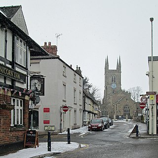
<span class="mw-page-title-main">Lutterworth</span> Town in Leicestershire, England

Lutterworth is a market town and civil parish in the Harborough district of Leicestershire, England. The town is located in southern Leicestershire, close to the borders with Warwickshire and Northamptonshire. It is located 6.4 miles north of Rugby, Warwickshire and 12 miles south of Leicester.

<span class="mw-page-title-main">Harborough District</span> Non-metropolitan district in England

Harborough is a local government district in Leicestershire, England. It is named after its main town, Market Harborough, which is where the council is based. The district also includes the town of Lutterworth and numerous villages and surrounding rural areas. In the north of the district it includes parts of the Leicester Urban Area, notably at Thurnby, Bushby and Scraptoft. Covering 230 square miles (600 km2), the district is the largest by area of the eight districts in Leicestershire and covers almost a quarter of the county.

<span class="mw-page-title-main">High Cross, Leicestershire</span> Road junction, historic site and locality in England

High Cross is the name given to the crossroads of the Roman roads of Watling Street and Fosse Way on the border between Leicestershire and Warwickshire, England. The parish boundaries of four villages meet at High Cross: the Warwickshire villages of Wibtoft and Copston Magna and the Leicestershire parishes of Sharnford and Claybrooke Parva. High Cross was the site of a Romano-British settlement known as Venonae or Venonis, with a nearby fort.

<span class="mw-page-title-main">Wibtoft</span> Human settlement in England

Wibtoft is a small village and civil parish in north-eastern Warwickshire, England. The village was originally within the civil parish of Claybrooke Magna in Leicestershire. According to the 2021 Census, it had a population of 62.

<span class="mw-page-title-main">Long Clawson</span> Village in Leicestershire, England

Long Clawson is a village and former civil parish, now included in that of Clawson, Hose and Harby, in the Melton district and the county of Leicestershire, England. Being in the Vale of Belvoir, the village is enclosed by farmland with rich soil ideal for pasture. Milk from local farms is used for Stilton cheese, of which the Long Clawson dairy is one of the largest producers. In 1931 the civil parish had a population of 664.

<span class="mw-page-title-main">Bitteswell</span> Village in Leicestershire, England

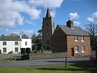
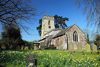
Bitteswell is a small village and former civil parish, now in the parish of Bitteswell with Bittesby, in the Harborough district of Leicestershire in England. It is situated just north of the town of Lutterworth, and in the 2001 census had a population of 454. The population had increased to 554 at the 2011 census. It was recorded in the Domesday Book as Betmeswelle. The village's name means 'the spring/stream in the broad valley'.

<span class="mw-page-title-main">Ullesthorpe</span> Human settlement in England

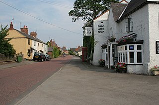
Ullesthorpe is a small village and civil parish situated in the Harborough district in southern Leicestershire. Ullesthorpe is noted for its historic background with a mill, disused railway station and traces of a medieval settlement evident on the edge of the village.

<span class="mw-page-title-main">Kilby</span> Human settlement in England

Kilby is a village and civil parish in the Blaby district of Leicestershire, England. Kilby is the easternmost village in the district, and is 6.1 miles (9.8 km) south east of Leicester. Kilby civil parish includes the former parish of Foston and it's deserted medieval village. Nearby places are Countesthorpe 2.21 miles (3.56 km), Fleckney 2.12 miles (3.41 km), Arnesby 1.96 miles (3.15 km), Wistow 1.4 miles (2.3 km) and Kilby Bridge 1.18 miles (1.90 km).

<span class="mw-page-title-main">Walkern</span> Village in Hertfordshire, England

Walkern is a village and civil parish in East Hertfordshire, England. It is about two miles (3 km) from Stevenage.

<span class="mw-page-title-main">Bittesby</span> Human settlement in England

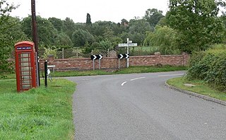
Bittesby is a deserted village and former civil parish, now in the parish of Bitteswell with Bittesby, in the Harborough district of Leicestershire, England. It is near the A5 Watling Street, about three miles from Lutterworth. The site of the village was adjacent to the route of the now disused Midland Railway. According to the 2001 census the parish had a population of 6.

The rural district of Lutterworth in Leicestershire, England existed from 1894 to 1974. It contained the following civil parishes:

<span class="mw-page-title-main">Claybrooke Parva</span>

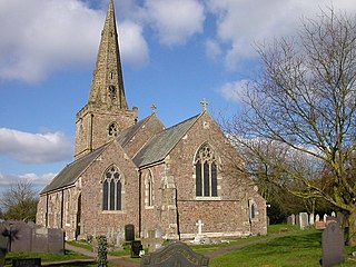
Claybrooke Parva is a village and civil parish in the Harborough district south west Leicestershire, England close to Claybrooke Magna. The village is the site of a church which is thought to originally be part Anglo Saxon with Norman and Medieval additions. The population of the civil parish at the 2011 census was 208.

<span class="mw-page-title-main">Willoughby Waterleys</span> Human settlement in England

Willoughby Waterleys is a small village and civil parish in the Harborough district of Leicestershire, England. It is situated near the A426 Leicester–to–Lutterworth road. Nearby villages are Ashby Magna, Peatling Magna and Countesthorpe. Main Street is the basis of the village running north to south, there have been some new developments such as bungalows and large detached houses however many farms still remain in the parish.

<span class="mw-page-title-main">Dunton Bassett</span> Human settlement in England

Dunton Bassett is a small village in the Harborough district of Leicestershire, England. It lies between Leicester and Lutterworth, and close to Broughton Astley, Ashby Magna & Leire. It had a population of 795 at the 2001 UK census, falling to 759 at the 2011 census.

<span class="mw-page-title-main">Gilmorton</span> Human settlement in England

Gilmorton is a village and civil parish about 3 miles (5 km) northeast of Lutterworth in Leicestershire, England. The 2011 Census recorded the parish population as 976.

<span class="mw-page-title-main">Peatling Parva</span> Human settlement in England

Peatling Parva is a village and civil parish in the Harborough district, south Leicestershire, England. It lies 2.6 km west-north-west of Ashby Magna and 2.9 km south-south-west of Peatling Magna.

<span class="mw-page-title-main">Calthorpe, Norfolk</span> Village in Norfolk, England

Calthorpe is a small village and former civil parish, now in the parish of Erpingham, in the North Norfolk district, in the county of Norfolk, England. The village is located 0.5 miles (0.80 km) west of the village of Erpingham, 3.4 miles (5.5 km) north of the nearest town of Aylsham and is 15.8 miles (25.4 km) north of the nearest city of Norwich. The nearest railway station is at Gunton for the Bittern Line which runs between Sheringham, Cromer and Norwich and is 7.8 miles (12.6 km) from the village. The nearest airport is Norwich International 14.2 miles (22.9 km) south of the village. In 1931 the parish had a population of 143.

<span class="mw-page-title-main">Bilstone</span> Human settlement in England

Bilstone is a small village and former civil parish, now in the parish of Shackerstone, in the Hinckley and Bosworth district of Leicestershire, England. It is approximately 12 miles (19 km) west from the county town and city of Leicester, and 2 miles (3.2 km) east from Twycross and the A444 road. In 1931 the parish had a population of 68.

References

  1. "Claybrooke Magna". Bartram & co. Archived from the original on 16 April 2014. Retrieved 6 April 2014.
  2. "Key to English Place-names". kepn.nottingham.ac.uk. Archived from the original on 18 August 2021. Retrieved 18 August 2021.
  3. Open Domesday: Claybrooke Magna and Parva Archived 27 March 2020 at the Wayback Machine , accessed March 2020.
  4. Wilson, John Marius (1870–72). Imperial Gazetteer of England and Wales. Edinburgh: A.Fullerton & Co. Archived from the original on 28 February 2014. Retrieved 24 February 2014.
  5. Historic England. "Planning (Listed Buildings and Conservation Areas) Act 1990 (1209151)". National Heritage List for England . Retrieved 2 March 2014.
  6. 1 2 "Claybrooke Mill Flour, Claybrooke Magna". Local Food Heroes Directory. Archived from the original on 30 January 2016. Retrieved 2 April 2014.
  7. Pevsner, N; Williamson, E (1984). The Buildings of England: Leicestershire and Rutland. London. p. 132.{{cite book}}: CS1 maint: location missing publisher (link)
  8. "THE VINEYARD DAIRY FARMHOUSE". Heritage Gateway. Archived from the original on 16 April 2014. Retrieved 3 April 2014.
  9. Historic England. "Planning (Listed Buildings and Conservation Areas) Act 1990 (1209151)". National Heritage List for England . Retrieved 16 April 2014.
  10. "Claybrooke Magna Village Hall". Rural Community Councils. Archived from the original on 16 April 2014. Retrieved 12 April 2014.
  11. 1 2 "TOURISM- CLAYBROOKE MAGNA". Domesday Reloaded. BBC. Archived from the original on 25 September 2015. Retrieved 20 April 2014.
  12. 1 2 Mcilvenna, Kathleen (2 January 2011). "Armchair Local History: Claybrooke". Archived from the original on 16 April 2014. Retrieved 2 April 2014.
  13. "Whitmore's Company History". Whitmores Timber. Archived from the original on 30 May 2016. Retrieved 3 April 2014.
  14. "RELIGION - CLAYBROOKE AREA". Domesday Reloaded. BBC. Archived from the original on 23 April 2014. Retrieved 4 April 2014.
  15. "Blue Bell, Claybrooke Magna, Leicestershire". The Lost Pubs Project. Archived from the original on 6 July 2014. Retrieved 21 April 2014.
  16. "Pig Pub Brewery Co". The Pig in Muck. Archived from the original on 16 April 2014. Retrieved 11 April 2014.
  17. "Claybrooke Magna (Parish): Key Figures for 2001 Census: Key Statistics". Neighbourhood Statistics. Office for National Statistics. Archived from the original on 2 March 2014. Retrieved 24 February 2014.
  18. "Industry, 2011 (QS605EW)". Neighbourhood Statistics. Area: Claybrooke Magna (Parish). Office for National Statistics. Archived from the original on 10 February 2015. Retrieved 22 April 2014.
  19. "Claybrooke Magna" (PDF). Leicestershire County Council. Archived (PDF) from the original on 31 May 2013. Retrieved 13 April 2014.
  20. "170 Years of Industrial Change across England and Wales". Office for National Statistics. Archived from the original on 5 January 2016. Retrieved 20 April 2014.
  21. "EMPLOYMENT IN CLAYBROOKE". Domesday Reloaded. BBC. Archived from the original on 25 September 2015. Retrieved 23 April 2014.