North Andaman Island is the northern island of Great Andaman of the Andaman Islands. It belongs to the North and Middle Andaman administrative district, part of the Indian union territory of Andaman and Nicobar Islands. the island is lying 137 km (85 mi) north from Port Blair.

Little Andaman Island is the fourth largest of the Andaman Islands of India with an area of 707 km², lying at the southern end of the archipelago. It belongs to the South Andaman administrative district, part of the Indian union territory of Andaman and Nicobar Islands. the island is lying 88 km (55 mi) south from Port Blair, the capital of Andaman and Nicobar Islands and the nearest airport from where regular flights to Kolkata and Chennai are available.
South Sentinel Island is one of the Andaman Islands in the Bay of Bengal. It is 1.6 km (0.99 mi) long northeast to southwest and up to 1 km (0.62 mi) wide. At only 1.61 km2 (0.62 sq mi), it is much smaller than its counterpart North Sentinel Island and of significantly less interest. The island belongs to the Port Blair tehsil in the South Andaman administrative district, part of the Indian union territory of Andaman and Nicobar Islands.
Interview Island is an island of the Andaman Islands. It belongs to the North and Middle Andaman administrative district, part of the Indian union territory of Andaman and Nicobar Islands. the island is lying 125 km (78 mi) north from Port Blair.
North Cinque Island or Gue-a-lue is an uninhabited island of the Andaman Islands. It belongs to the South Andaman administrative district, part of the Indian union territory of Andaman and Nicobar Islands. the island is lying 37 km (23 mi) south from Port Blair.
South Cinque Island or Ga-o-ta-koi is an uninhabited island of the Andaman Islands. It belongs to the South Andaman administrative district, part of the Indian union territory of Andaman and Nicobar Islands. The island lies 41 km (25 mi) south from Port Blair.
Bluff Island is an island of the Andaman Islands. It belongs to the North and Middle Andaman administrative district, part of the Indian union territory of Andaman and Nicobar Islands. The island lies 64 km (40 mi) north from Port Blair.
Sister Islands are a group of uninhabited islands of the Andaman Islands. They belong to the South Andaman administrative district, part of the Indian union territory of Andaman and Nicobar Islands. the island is lying 57 km (35 mi) south from Port Blair.
East Sister Island or Takoa-te is a small uninhabited island in the Andaman Archipelago, at the northern side of the Duncan Passage, about 6 km southeast of Passage Island and 18 km north of North Brother.
8West Sister Island or Te-joma-de is a small uninhabited island in the Andaman Archipelago, at the northern side of the Duncan Passage, about 6 km southeast of Passage Island and 18 km north of North Brother.
Landfall Island is the northernmost island of the Indian union territory of Andaman and Nicobar Islands. It belongs to the territory's North and Middle Andaman administrative district. The island lies 220 km (137 mi) north of Port Blair, and is situated 300 km (186 mi) km from Burma. It is home to the Kari tribe.
East Island is an island of the Andaman Islands. It belongs to the North and Middle Andaman administrative district, part of the Indian union territory of Andaman and Nicobar Islands. the island is lying 220 km (137 mi) north from Port Blair.
West Island is an island of the Andaman Islands. It belongs to the North and Middle Andaman administrative district, part of the Indian union territory of Andaman and Nicobar Islands. The island lies 212 km (132 mi) north from Port Blair.
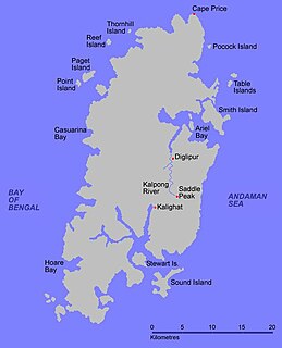
Paget Island is an island of the Andaman Islands. It belongs to the North and Middle Andaman administrative district, part of the Indian union territory of Andaman and Nicobar Islands. the island is lying 195 km (121 mi) north from Port Blair.
Smith Island is an island of the Andaman Islands. It belongs to the North and Middle Andaman administrative district, part of the Indian union territory of Andaman and Nicobar Islands. The island lies 298 km (185 mi) north of Port Blair.
Aves Island is an island of the Andaman Islands. It belongs to the North and Middle Andaman administrative district, part of the Indian union territory of Andaman and Nicobar Islands. The island lies 140 km (87 mi) north from Port Blair.
Spike Island is an island of the Andaman Islands. It belongs to the North and Middle Andaman administrative district, part of the Indian union territory of Andaman and Nicobar Islands. The island lies 63 km (39 mi) north from Port Blair.
North Passage Island is an island of the Andaman Islands. It belongs to the North and Middle Andaman administrative district, part of the Indian union territory of Andaman and Nicobar Islands. The island lies 80 km (50 mi) north from Port Blair.
Kyd Island is an island of the Andaman Islands. It belongs to the South Andaman administrative district, part of the Indian union territory of Andaman and Nicobar Islands. the island lies 30 km (19 mi) north from Port Blair.
Passage Island or Duncan Island is an uninhabited island of the Andaman Islands. It belongs to the South Andaman administrative district, part of the Indian union territory of Andaman and Nicobar Islands. The island is 53 km (33 mi) south from Port Blair.


