Clonaslee

Last updated • 3 min readFrom Wikipedia, The Free Encyclopedia

Clonaslee
Cluain na Slí
Village
IMG Clonaslee3232c.jpg
Clonaslee, R422 heading west into the village
Ireland adm location map.svg
Red pog.svg
Clonaslee
Location in Ireland
Coordinates: 53°08′56″N7°31′31″W / 53.1488°N 7.5253°W / 53.1488; -7.5253
Country Ireland
Province Leinster
County County Laois
Population
 (2022) [1]
608
Time zone UTC+0 (WET)
  Summer (DST) UTC-1 (IST (WEST))
Irish grid reference N318110

Clonaslee (Irish : Cluain na Slí) [2] is a village in north County Laois, Ireland, situated in the foothills of the Slieve Bloom Mountains on the R422 Mountmellick to Birr road. Clonaslee is approximately 100 km west of Dublin, and is close to the towns of Portlaoise and Tullamore.

Contents

As of the 2022 census, the village had a recorded population of 608. [1]

Name

The primary spelling of the name, Clonaslee, is associated by several sources to the Irish Cluain na Slí (translated as "pasture of the way" or "roadside meadow" or similar) and related to the village's location on ancient cross-country route. [2] [3]

Though this is the commonly and officially accepted version, an alternative spelling of the name, Cloneslieu, is associated by some sources to the Irish Cluain na Sléibhe (translated as "the mountain meadow"). [3]

The original name of the parish, Kilmanman, from the Irish Cill na mBanbhán or Cill Mheanman (translated as "the church of Manman"), is associated with Saint Manman who founded a church here in the 7th century. [4] [3]

History

Clonaslee village and church Clonaslee village 01.jpg
Clonaslee village and church

While earlier archaeological remains suggest more ancient settlement in the area (including a ringfort in nearby Larragan townland), [5] the modern day Clonaslee evolved from its beginnings as an Anglo-Norman town of the late-12th century.[ citation needed ] At this time the eskers and related landforms gave a great strategic advantage by providing ideal vantage points where mottes and other defensive battlements were constructed. This advantage also had a profound influence on the location of towns and villages throughout the county. From the 12th to 17th centuries, recorded history does not provide much detail on the development of Clonaslee.

The most significant period in the village's growth took place from the 16th century under the influence of the Dunnes of Brittas.[ citation needed ] This family left their mark on the form and history of the village as evidenced in its planned form and also from a number of ruins in the area. The former residence of a young branch of the family remains in ruins one mile from the village at Clara Hill. Also, near the east bank of the Clodiagh River stand the ruins of Ballinakill Castle, built in 1680 by Colonel Dunne. Throughout the 18th century, Clonaslee prospered due to its location on an important highway across Laois leading onto Munster. The proximity of Brittas - the seat of the Dunnes - was also influential as the power of this family had by now grown beyond that of a native Irish Chieftain. In 1771, Francis Dunne, then head of the Dunne Family, became a Roman Catholic and built a thatched parish chapel in the village. This was located close to the site of the present church.

The Dunne family continued to finance the construction of landmark buildings in the village. The parish church was erected in 1814 under General Dunne (known locally as 'shun-battle Ned' because of his rumoured refusal to fight at the 1815 Battle of Waterloo). The construction of the church was aided by a gift of £800 and a loan of £300 from the former Board of First Fruit. In 1830, the same board donated £50 towards the construction of Glebe House. The village continued to grow quickly from the 1800s to the 1830s. This was largely due to the development of the Mountmellick to Birr road in 1814. This period also saw the arrival of civic facilities such as the post office, police station and other offices of civil administration. The population of the village peaked at 561 inhabitants in 1841. However, in 1901 this fell to a low of 287 persons. As of the 2022 census, the population was 608. [1]

Amenities

Local walks and trails include Slieve Bloom Forest Park, the Giant's Grave, and Brittas Lake and Forest - the latter of which is managed by Coillte. [6] The ruined tower of Brittas Castle, largely destroyed by fire in the mid-20th century, [7] has a gateway from Clonaslee's main street. [8]

Clonaslee–St Manman's is the local Gaelic Athletic Association club.

Notable people

Related Research Articles

<span class="mw-page-title-main">County Laois</span> County in Ireland

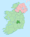
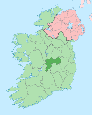
County Laois is a county in Ireland. It is part of the Eastern and Midland Region and in the province of Leinster. It was known as Queen's County from 1556 to 1922. The modern county takes its name from Loígis, a medieval kingdom. Historically, it has also been known as County Leix.

<span class="mw-page-title-main">Rosenallis</span> Village in County Laois, Ireland

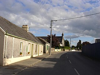
Rosenallis is a village in north County Laois, Ireland. It is in the foothills of the Slieve Bloom Mountains on the R422 Mountmellick to Birr road, 6 km north-west of Mountmellick. The village is in a townland and civil parish of the same name.

<span class="mw-page-title-main">County Offaly</span> County in Ireland

County Offaly is a county in Ireland. It is part of the Eastern and Midland Region and the province of Leinster. It is named after the ancient Kingdom of Uí Failghe. It was formerly known as King's County, in honour of Philip II of Spain. Offaly County Council is the local authority for the county. The county population was 82,668 at the 2022 census.

<span class="mw-page-title-main">Clara, County Offaly</span> Town in County Offaly, Ireland

Clara is a town on the River Brosna in County Offaly, Ireland. It is the 10th largest town in the midlands of Ireland. The town had a population of 3,403 as of the 2022 census.

<span class="mw-page-title-main">Kilcormac</span> Village in County Offaly, Ireland

Kilcormac is a small village in County Offaly, Ireland, located on the N52 at its junction with the R437 regional road, between the towns of Tullamore and Birr. It is a small village of 935 people, many of whom were previously employed by Bord na Móna to work the local peat bogs. The village is located near the Slieve Bloom Mountains. The Silver River flows through the village. The village was more commonly referred to as Frankford prior to Irish independence.

<span class="mw-page-title-main">Clonegal</span> Village in County Carlow, Ireland

Clonegal, officially Clonegall, is a village in the southeast of County Carlow, Ireland. It is in a rural setting, close to the border between counties Wexford and Carlow, 5 km (3 mi) from Bunclody, County Wexford and 22 km (14 mi) from Carlow town. It is just over a mile north of where the River Slaney and the River Derry meet. Clonegal has a much smaller "twin" village across the River Derry in County Wexford, Watch House Village.

<span class="mw-page-title-main">Kinnitty</span> Village in Leinster, Ireland

Kinnitty is a village in County Offaly, Ireland. It is located 13 km east of Birr on the R440 and R421 regional roads. The village is in a civil parish of the same name.

<span class="mw-page-title-main">Murroe</span> Village in County Limerick, Ireland

Murroe, officially spelled Moroe, is a village in County Limerick, Ireland.

Dunne or Dunn is an Irish surname, derived from the Irish Ó Duinn and Ó Doinn, meaning "dark" or "brown." The name Dunne in Ireland is derived from the Ó Duinn and the Ó Doinn Gaelic septs who were based in County Laois, County Meath and County Wicklow. These septs in turn are descendants of the O'Regan noble family. It is in these counties that the majority of descendants can still be found. Hundreds of years ago, the Gaelic name used by the Dunn family in Ireland was Ó Duinn or Ó Doinn. Both Gaelic names are derived from the Gaelic word donn, which means "brown". Ó Doinn is the genitive case of donn. First found in county Meath, where they held a family seat from very ancient times. Variations: Dunn, Dunne, Dun, Duen, O'Dunne, O'Doyne, Doine, Doin, O'Dunn.

Clonaslee–St Manman's GAA is a Gaelic Athletic Association hurling and Gaelic football club in Clonaslee, County Laois, Ireland.

Rosenallis Gaelic Athletic Association club is a hurling and Gaelic football club in the village of Rosenallis in County Laois, Ireland.

<span class="mw-page-title-main">Clareen</span> Village in Leinster, Ireland

Clareen is a village in the parish of Seir Kieran in County Offaly, Ireland. It is located 8 km east of Birr on the R421 regional road.

<span class="mw-page-title-main">Kilnaboy</span> Village in County Clare, Ireland

Kilnaboy or Killinaboy is a village, townland and civil parish in County Clare, Ireland. It is located in the Burren, and as of the 2011 census the area had 347 inhabitants.

<span class="mw-page-title-main">Farran</span> Village in County Cork, Ireland

Farran is a village in County Cork, Ireland, in the parish of Ovens. It lies on the southside of the River Lee. Farran is 12 miles (19 km) west from Cork City on the N22 road.

<span class="mw-page-title-main">Clonaghadoo</span> Village

Clonaghadoo is a village in County Laois, Ireland, located 6 km (3.7 mi) north of Mountmellick just off the N80 national secondary road. The Slieve Bloom Mountains lie southwest of the village. The village is part of the Roman Catholic parish Mountmellick.

Cullahill Mountain is listed as a marilyn hill and a Special Area of Conservation in County Laois, Ireland. Cullahill with an elevation of 313 m (1,027 ft) gives its name to the local townland. It is also called Knockmannon Hill.

<span class="mw-page-title-main">Kilcorney, County Clare</span> Civil parish in County Clare, Ireland

Kilcorney is a civil parish in County Clare, Ireland. It lies in the Burren region of the northwest of the county.

Leitrim is a barony in Ireland that lies partly in County Galway and partly in County Clare. It is located in the south-eastern corner of County Galway and the north-eastern corner of County Clare. Prior to 1898, the entire barony was contained in County Galway. The Local Government (Ireland) Act 1898 split the barony: part of the barony was transferred to County Clare. Leitrim is bounded, clockwise from the southwest, by the Clare baronies of Tulla Upper and Tulla Lower; the Galway baronies of Loughrea to the west, Kilconnell to the north, and Longford to the east; and by Lough Derg to the south and southeast. It measures 20 miles (32 km) from north to south and 9.5 miles (15.3 km) from east to west.

Gerard Culliton was an Irish international rugby union player. A native of Clonaslee in County Laois, he won 19 caps for Ireland, playing in four different positions.

References

  1. 1 2 3 "Sapmap Area - Settlements - Clonaslee". Census 2022. Central Statistics Office. 2022. Retrieved 4 October 2024.
  2. 1 2 "Cluain na Slí / Clonaslee". logainm.ie. Irish Placenames Commission. Retrieved 11 January 2019. Explanatory note [..] the pasture of the road, way
  3. 1 2 3 "Villages - Clonaslee". slievebloom.ie. Offaly County Council. Retrieved 11 January 2019.
  4. "Cill na mBanbhán / Kilmanman" (in Irish). Irish Placenames Commission. Retrieved 11 November 2018.
  5. P. David Sweetman; Olive Alcock; Bernie Moran, eds. (1995). Archaeological Inventory of County Laois. Dublin Stationery Office. LA002-009 [..] Ringfort - rath [..] Townland: LARRAGAN
  6. "Brittas Forest". coillte.ie. Coillte. 11 January 2019. Brittas Forest in Clonaslee village, follows the path of the River Clodiagh [..] The trail passes by Brittas lake and car park
  7. "1869 – Brittas Castle, Clonaslee, Co. Laois". Architecture of Laois. Archiseek. 2013. Retrieved 11 January 2019. Brittas Castle went on fire on Thursday, June 25, 1942 and, despite the best efforts of the Tullamore Fire Brigade, it was destroyed. Little remains today but the ruined tower
  8. "Brittas House, Brittas Demesne, County Laois". buildingsofireland.ie. National Inventory of Architectural Heritage. Retrieved 11 January 2019. built in 1869 to designs by John McCurdy [..] Remainder of house dismantled to ground level [..] Gateway to site (at Main Street, Clonaslee) comprising sandstone piers.
  9. "19 caps for Ireland, the Barbarians and a junior hurling title with Clonaslee – the amazing sporting career of Gerry Culliton". laoistoday.ie. 9 February 2019. Retrieved 23 June 2023.
  10. "Midlands Weather Forecast Icon Retires". midlands103.com. 1 June 2023. Retrieved 23 June 2023.
  11. "Mick Dunne dies, aged 73". Irish Times. 12 August 2002. Retrieved 23 June 2023.