Cloud, Iowa | |
|---|---|
 Cloud  Cloud | |
| Coordinates: 41°10′30″N93°14′07″W / 41.17500°N 93.23528°W | |
| Country | United States |
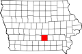
| State | Iowa |
| County | Marion |
| Elevation | 935 ft (285 m) |
| Time zone | UTC-6 (Central (CST)) |
| • Summer (DST) | UTC-5 (CDT) |
| Area code | 641 |
| GNIS feature ID | 464265 [1] |
Cloud is an unincorporated community in Marion County, Iowa, United States. [1]