Clover Valley (Nevada)

Last updated
Clover Valley (Nevada)
2013-06-27 12 37 38 View of Clover Valley in Nevada from Spruce Mountain.jpg
View of Clover Valley, Nevada from Spruce Mountain
Relief map of USA Nevada.png
Red pog.svg
Clover Valley (Nevada)
Clover Valley at Tobar
Length 37 mi (60 km)N-S
Width 20 mi (32 km)
Geography
Country United States
State Nevada
Region Great Basin
County Elko
Population center Wells
Borders on
Coordinates 40°53′47″N114°53′25″W / 40.89639°N 114.89028°W / 40.89639; -114.89028 Coordinates: 40°53′47″N114°53′25″W / 40.89639°N 114.89028°W / 40.89639; -114.89028
Lake Snow Water Lake

The Clover Valley of Nevada, is a 37-mile (60 km) long [1] valley located in central-southeast Elko County. Wells, Nevada lies at its north end, on I-80.

Nevada State of the United States of America

Nevada is a state in the Western United States. It is bordered by Oregon to the northwest, Idaho to the northeast, California to the west, Arizona to the southeast and Utah to the east. Nevada is the 7th most extensive, the 32nd most populous, but the 9th least densely populated of the U.S. states. Nearly three-quarters of Nevada's people live in Clark County, which contains the Las Vegas–Paradise metropolitan area where three of the state's four largest incorporated cities are located. Nevada's capital, however, is Carson City.

Elko County, Nevada County in the United States

Elko County is a county in the northeastern corner of the U.S. state of Nevada. As of the 2010 census, the population was 48,818. Its county seat is Elko. The county was established on March 5, 1869, from Lander County.

Wells, Nevada City in Nevada, United States

Wells is a small city in Elko County, in northeast Nevada in the western United States. The population was 1,292 at the 2010 census. Wells is located at the junction of Interstate 80 and U.S. Route 93, approximately 50 miles (80 km) east of Elko and is part of the Elko micropolitan area.

Contents

Clover Valley lies at the east flank of the mostly north-trending East Humboldt Range, which supplies numerous creeks to the north valley; the mountain forests supplying the water are a section of the Humboldt-Toiyabe National Forest. A slough exists in the north which drains south to intermittent Snow Water Lake.

East Humboldt Range

The East Humboldt Range is a mountain range in Elko County, Nevada, United States. It is located along the eastern edge of the upper watershed of the Humboldt River, which flows to the southwest from its source just north of the range. The range reaches a maximum elevation of 11,306 feet (3,446 m) atop Hole in the Mountain Peak. Most of the range is included within the Ruby Mountains Ranger District of the Humboldt-Toiyabe National Forest. In 1989, the United States Congress passed the Nevada Wilderness Protection Act establishing over 36,000 acres (150 km2) of the range as the East Humboldt Wilderness. The range takes its name from the Humboldt River. The name ultimately is derived from the German naturalist Alexander von Humboldt.

Description

Clover Valley trends north-south. The Wood Hills lie along the northeast and eastern edge, to the southeast of Wells; Spruce Mountain is south-southeast.

Wood Hills

The Wood Hills are a mountain range in Elko County, Nevada.

Spruce Mountain (Nevada) mountain in Nevada, United States of America

Spruce Mountain is a mountain in Elko County, Nevada, United States. It was named from the spruce timber near the summit. Spruce Mountain ranks twenty-fifth among the most topographically prominent peaks in the state. The summit is at 10,267 feet (3,129 m). Spruce Mountain is on a northeast–southwest trending ridge with a parallel Spruce Ridge to the northwest. To the east, a low section of hills connects the mountain to the south end of the Pequop Mountains. US Route 93 passes the southwest end of the mountain. The peak is on public land administered by the Bureau of Land Management and thus has no access restrictions.

Dissected lowlands or flatlands surround Snow Water Lake, which lies near the valley's center, except on its west at the East Humboldt Range foothills bordering the lake.

History

The first permanent settlement at Clover Valley was made in 1864. [2] A station on the Western Pacific Railroad between Ventosa and Wells was named for a directional sign posted on the building pointing the way to the local bar. Crudely written it was read and assumed to be the location of TOBAR. [3]

Western Pacific Railroad defunct American railroad (1916–1982)

The Western Pacific Railroad was a Class I railroad in the United States. It was formed in 1903 as an attempt to break the near-monopoly the Southern Pacific Railroad had on rail service into northern California. WP's Feather River Route directly competed with SP's portion of the Overland Route for rail traffic between Salt Lake City/Ogden, Utah, and Oakland, California, for nearly 80 years. In 1983, the Western Pacific was acquired by the Union Pacific Corporation and it was soon merged into their Union Pacific Railroad. The Western Pacific was one of the original operators of the California Zephyr.

A post office established at the site as Clover City and changed to Tobar December 20, 1911 and renamed Clover City again December 11, 1918. Tobar again became active from January 18, 1921 until it was decommissioned September 17, 1942. [3]

Access

U.S. Route 93 extends through the valley's west from Wells, south to the south terminus of the East Humboldt Range, at Warm Creek Ranch; Route 93 continues southeasterly to Currie in Goshute Valley. From the west, Nevada State Route 229 from north Ruby Valley connects to US 93 south of Warm Creek Ranch.

U.S. Route 93 in Nevada highway in Nevada

In the U.S. state of Nevada, U.S. Route 93 is a major United States Highway traversing the eastern edge of the state. The highway connects the Las Vegas area to the Great Basin National Park, and provides further connections to Ely and Wells. US 93 also provides the majority of the most direct connection from the major metropolitan areas of Las Vegas and Phoenix to the Boise, Idaho Metropolitan Area with a final connection to Boise via Interstate 84 from Twin Falls, Idaho.

Currie, Nevada Unincorporated community in Nevada, United States

Currie is an unincorporated community in Elko County, Nevada, United States. It is often considered a ghost town, and its population is around 20.

Goshute Valley

The Goshute Valley is an endorheic landform of the Great Basin. The towns of Oasis and Cobre are in the valley's north, and the central and north of the valley contains broken flatlands, with short washes draining from the surrounding mountain ranges.

In the northwest, south of Wells, Nevada 232 follows the foothills west of the Slough region, where about fifteen creeks descend from the East Humboldt Range. All other interior valley regions are accessed by unimproved roads. The north perimeter of the valley is approximately where Interstate 80 travels east from Wells.

Related Research Articles

Walker River river in the United States of America

The Walker River is a river in west-central Nevada in the United States, approximately 62 miles (100 km) long. Fed principally by snowmelt from the Sierra Nevada mountains of California, it drains an arid portion of the Great Basin southeast of Reno and flows into the endorheic basin of Walker Lake. The river is an important source of water for irrigation in its course through Nevada; water diversions have reduced its flow such that the level of Walker Lake has fallen 160 feet (49 m) between 1882 and 2010. The river was named for explorer Joseph Reddeford Walker.

Hole in the Mountain Peak mountain in United States of America

Hole in the Mountain Peak is the highest mountain in the East Humboldt Range of mountains in Elko County, Nevada, United States. It is the thirty-fifth highest mountain in the state, and also ranks as the eleventh-most topographically prominent peak in the state. It is located within the East Humboldt Wilderness of the Humboldt-Toiyabe National Forest and is 11,311 feet (3,448 m) high. The peak is 35 miles (56 km) east of Elko and 14 miles (23 km) southwest of Wells, making it a rather prominent feature of the drive along Interstate 80 in Elko County. The U.S. Board on Geographic Names lists two variant names, Mount Bonpland and Mount Bonplant.

Nevada State Route 232 highway in Nevada

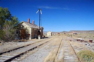
State Route 232 is a state highway in Elko County, Nevada. It covers the majority of Clover Valley Road south of Wells.

Ruby Valley

Ruby Valley is a large basin located in south-central Elko and northern White Pine counties in the northeastern section of the state of Nevada in the western United States. From Secret Pass it runs south-southwest for approximately 60 miles (96 km) to Overland Pass. To the west is the steep escarpment of the Ruby Mountains, and to the north is the East Humboldt Range and Clover Valley. The east side of the valley is less well defined, but its maximum width is about 10 miles (16 km) near Franklin Lake. At its south end lies the Ruby Lake National Wildlife Refuge.

Fish Lake Valley valley in southwest Nevada

The Fish Lake Valley is a 25 miles (40 km) long endorheic valley in southwest Nevada, one of many contiguous inward-draining basins collectively called the Great Basin. The alluvial valley lies just northwest of Death Valley and borders the southeast, and central-northeast flank of the massif of the White Mountains of California. The valley's southern end lies in eastern Inyo County, California. The valley is sparsely populated with ranchers and indigenous Paiute. Business services are located in the valley's only town Dyer.

Fortification Range

The Fortification Range is a mountain range in Lincoln and White Pine counties, Nevada. The range is a narrow linear range trending north-northwest with a length of 34 km (21 mi) and a width of about 8 km (5.0 mi). It is typical of the Basin and Range Province.

Piute Valley

The Piute Valley is a 45-mile-long (72 km) north–south valley southeast of Las Vegas, Nevada, and northwest of Needles. The north of the valley is at Searchlight, with some of the valley extending northwest from Searchlight. At the center-north lies Cal-Nev-Ari, Nevada.

Antelope Valley (Lander County)

The Antelope Valley of west Lander County is a small, 25 mile long, mostly arid valley in central Nevada, USA. A fourth valley of the same name Antelope Valley lies in southern Eureka County, east of the Monitor Range. The Lander County valley lies south of the Humboldt River and with Antelope Creek, is a western tributary valley to the north-flowing Reese River.

Antelope Valley (Eureka County)

The Antelope Valley of southern Eureka County is a small 35 mi long valley, surrounded by four mountain ranges. Antelope Wash flows north, to endorheic flatlands at the valley's north end. Eureka, Nevada lies 20 mi east nestled among mountain ranges. From Eureka U.S. Route 50 travels west through the north end of the valley on a route to Austin.

Antelope Valley (Elko-White Pine Counties)

The Antelope Valley adjacent to the Nevada/Utah state line, and located in southeast Elko County and northeast White Pine County, Nevada is a 70 mi (113 km) long endorheic valley. The valley curves around the Dolly Varden and Kinsley Mountains, and the Antelope Range.

Sevier Desert Desert located in the southeast of the Great Basin

The Sevier Desert is a large arid section of central-west Utah, United States, and is located in the southeast of the Great Basin. It is bordered by deserts north, west, and south; its east border is along the mountain range and valley sequences at the perimeter of the Great Basin, with the large north-south Wasatch Range and its associated mountainous landforms. Its eastern border is specifically, the East Tintic, Gilson, and Canyon Mountains; also the massive Pavant Range.

Lake Valley (Nevada)

Lake Valley is a 60-mile (97 km) long valley in northeast Lincoln County, Nevada. The North Lake Valley is an endorheic basin; South Lake Valley contains Patterson Wash, a northwest headwater tributary to the Meadow Valley Wash; the northeast headwater section of Meadow Valley Wash is a shorter drainage coming from the south of the Wilson Creek Range, the northeast border of South Lake Valley.

Bull Valley Mountains

The Bull Valley Mountains are a 30-mi (48 km) long, mountain range in southwest Utah, located in northwest Washington County. The range is adjacent the Utah border and attached to the Clover Mountains of southeast Nevada. The Great Basin Divide transects the summits of both ranges, with the Escalante Desert north and northeast of the Bull Valley Mountains, and south of the mountains the Colorado River watershed, and specifically the Santa Clara River which drains southeasterly from an escarpment along the mountain range's southeast flank.

Las Vegas Valley (landform) basin located in the U.S. state of Nevada

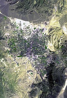
Las Vegas Valley is a basin in the U.S. state of Nevada. The valley in the northwest section is a northwest-by-southeast trending area, and trending parallel to Las Vegas Wash, lies at the northeast of the Spring Mountains massif.

Hamlin Valley valley on both sides of the Nevada–Utah state line

Hamlin Valley is a mostly north-south trending valley of the Great Basin located on both sides of the Nevada–Utah state line. It is about 60 miles (97 km) long. Its north-northeast end point adjacent the state line, is the southwest start region of the Snake Valley.

Fish Springs Range mountain range in Juab County, Utah, United States

The Fish Springs Range is a 16-mile (26 km) long narrow, and north-trending mountain range located in center-west Juab County, Utah. The northeast of the range borders the Fish Springs National Wildlife Refuge; the entire east of the range borders the Fish Springs Flat, where the east region of the flat borders the Thomas Range.

Goshen Valley

The Goshen Valley is a 17-mile-long (27 km) valley located in southern Utah County, Utah, and the valley forms part of its southeast border with the Wasatch Front, and parts of the Wasatch Range. The valley is an extension southwesterly of the Utah Valley.

Buena Vista Valley

The Buena Vista Valley is an approximately 40-mile (64 km) long valley located in central-east Pershing County, Nevada. Unionville, Nevada lies at its northwest, at the foothills of the Humboldt Range.

Grass Valley (Pershing County)

The Grass Valley of Pershing County, Nevada is a 30-mile (48 km) long valley located in the county's northeast. The north section of the valley is part of the southwest portion of Winnemucca on the Humboldt River. Clear Creek flows down the valley center, north-northwesterly and joins the Humboldt at Rose Creek, Nevada, 10-mi southwest of Winnemucca. The census-designated place of Grass Valley, with a population of 1,161, occupies the central 8 miles (13 km) of the valley.

References

  1. Nevada, DeLorme Atlas & Gazetteer, pp. 32-33.
  2. Federal Writers' Project (1941). Origin of Place Names: Nevada (PDF). W.P.A. p. 22.
  3. 1 2 Carlson, Helen S. (1985). Nevada place names : a geographical dictionary. Reno: University of Nevada Press. p. 232. ISBN   0-87417-094-X.