The Shoshone or Shoshoni are a Native American tribe with four large cultural/linguistic divisions:

The Feather River is the principal tributary of the Sacramento River, in the Sacramento Valley of Northern California. The river's main stem is about 73 miles (117 km) long. Its length to its most distant headwater tributary is just over 210 miles (340 km). The main stem Feather River begins in Lake Oroville, where its four long tributary forks join—the South Fork, Middle Fork, North Fork, and West Branch Feather Rivers. These and other tributaries drain part of the northern Sierra Nevada, and the extreme southern Cascades, as well as a small portion of the Sacramento Valley. The total drainage basin is about 6,200 square miles (16,000 km2), with approximately 3,604 square miles (9,330 km2) above Lake Oroville.

The Amargosa River is an intermittent waterway, 185 miles (298 km) long, in southern Nevada and eastern California in the United States. It drains a high desert region, the Amargosa Valley in the Amargosa Desert northwest of Las Vegas, into the Mojave Desert, and finally into Death Valley where it disappears into the ground aquifer. Except for a small portion of its route in the Amargosa Canyon in California and a small portion at Beatty, Nevada, the river flows above ground only after a rare rainstorm washes the region. A 26-mile (42 km) stretch of the river between Shoshone and Dumont Dunes is protected as a National Wild and Scenic River. At the south end of Tecopa Valley the Amargosa River Natural Area protects the habitat.
The Pah Rah Range is a mountain range located in western Nevada in Washoe County just to the northeast of Reno. It is a hook shaped range with the main eastern portion oriented northwest-southeast, approximately 20 miles (32 km) long. The northwest flowing Cottonwood Creek in Warm Springs Valley is bounded on three sides by the range. To the south and east the Truckee River forms the boundary and Pyramid Lake is at the northeast. Spanish Springs Valley north of Reno forms the southwest margin. To the north the narrow Mullen Pass separates the Pah Rah Range from the Virginia Mountains.

The Mohave Valley is a valley located mostly on the east shore of the south-flowing Colorado River in northwest Arizona. The valley extends into California's San Bernardino County; the northern side of the valley extends into extreme southeast Clark County, Nevada. The main part of the valley lies in southwest Mohave County, Arizona and is at the intersection of the southeast Mojave and northwest Sonoran deserts.

The Virginia Mountains is an irregular mountain range entirely in Washoe County, Nevada, that generally extends north-northwest to south-southeast for 22 miles (35 km).

Sonoita Creek is a tributary stream of the Santa Cruz River in Santa Cruz County, Arizona. It originates near and takes its name from the abandoned Pima mission in the high valley near Sonoita. It flows steadily for the first 15 miles (24 km) of its westward course past Patagonia, its bird sanctuary and Patagonia Lake, but sinks beneath the sand seven to eight miles before joining the Santa Cruz River a few miles north of Nogales. This confluence provides water for Tumacácori and Tubac and collects in the marsh lands around San Xavier del Bac downstream, to the north. The Santa Rita Mountains lie to the north and the Canelo Hills, Red Mountain and the Patagonia Mountains lie to the south. Harshaw Creek is a southern tributary which joins the Sonoita near Patagonia. Harshaw Creek drains the area between the Patagonia Mountains to the west and the high San Rafael Valley grasslands to the east. The ghost town of Harshaw lies within its watershed.
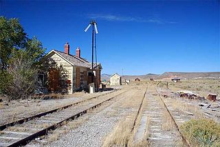
The BHP Nevada Railroad was a shortline railroad that operated in Nevada from 1996 to 1999. BHP acquired the line from Nevada Northern Railway. Constructed by Utah Construction Company in 1908, the railroad hauled copper ore concentrate from BHP's concentrator at Riepetown to Shafter, Nevada. At Shafter the railroad interchanged with the Union Pacific and the ore continued to BHP's smelter at San Manuel, Arizona. BHP is an Australian-based company that took over Magma Copper, the owner of the Robinson Mine at Ruth, Nevada, in January 1996. The line ran south from a connection with the Union Pacific at Shafter to Ely.

The San Jacinto River is a 42-mile-long (68 km) river in Riverside County, California. The river's headwaters are in Santa Rosa and San Jacinto Mountains National Monument. The lower portion of the 765-square-mile (1,980 km2) watershed is urban and agricultural land. As a partially endorheic watershed that is contiguous with other Great Basin watersheds, the western side of the San Jacinto Basin is a portion of the Great Basin Divide.
The Cherry Creek Range is a line of mountains, Basin and Range faulted, in northern White Pine and southern Elko Counties, in northeastern Nevada in the western United States. The range runs generally north–south for approximately 50 miles (80 km). The highest point in the range is an unnamed peak, located just south of the border between the counties.
Currie is an unincorporated community in Elko County, Nevada, United States. It is often considered a ghost town, and its population is around 20.

The Middle Fork Feather River is a major river in Plumas and Butte Counties in the U.S. state of California. Nearly 100 miles (160 km) long, it drains about 1,062 square miles (2,750 km2) of the rugged northern Sierra Nevada range.

The Fish Lake Valley is a 25 miles (40 km) long endorheic valley in southwest Nevada, one of many contiguous inward-draining basins collectively called the Great Basin. The alluvial valley lies just northwest of Death Valley and borders the southeast, and central-northeast flank of the massif of the White Mountains of California. The southwestern portion of the valley lies in California, with the southern tip at the edge of Inyo County east of the Chocolate Mountains, and a significant portion of the south end of the valley floor including the ranching community of Oasis, in Mono County. The valley is sparsely populated, primarily with ranchers and indigenous Paiute. The valley's Post Office and commercial services are located in the town of Dyer.

The Sacramento Wash is a major drainage of northwest Arizona in Mohave County. The wash is east of the Black Canyon of the Colorado and drains into the south-flowing Colorado River 45 mi south of Lake Mohave, and 90 mi south of Hoover Dam at Lake Mead. The wash outfall is in the center-south of the Havasu-Mohave Lakes Watershed. An equivalent wash drains to the west of the Colorado River and the Black Canyon, draining southeast Nevada and a small part of California, the Piute Wash of the Piute Valley. The Piute Wash outfall is upstream of the Sacramento's outfall by about 15 miles.

The Piute Wash of extreme southeastern Nevada and northeast San Bernardino County California is the south-flowing drainage of the Piute Valley. The wash and valley are located northwest of Needles, California.

The Whitlock Valley is a small valley in southeast Arizona, USA, lying between three mountain ranges. The valley lies on the south perimeter region of the White Mountains in eastern Arizona, and lies south of the west-flowing Gila River, and the region transitions south into Cochise County and three large valleys, with some scattered dry lakes. The valley is endorheic, with a small dry lake called Parks Lake, and merges southwest into the north of the San Simon Valley, where the San Simon River has its origins in the flatlands, and surrounding perimeter mountains. The valley was named after Captain James H. Whitlock who commanded during the Battle of Mount Gray in 1864 which was fought near the valley.

The Sevier Desert is a large arid section of central-west Utah, United States, and is located in the southeast of the Great Basin. It is bordered by deserts north, west, and south; its east border is along the mountain range and valley sequences at the perimeter of the Great Basin, with the large north–south Wasatch Range and its associated mountainous landforms. Its eastern border is specifically, the East Tintic, Gilson, and Canyon Mountains; also the massive Pahvant Range.
Deep Creek Valley is a 35-mile (56 km) long valley located in southwest Tooele County at the Utah-Nevada border; the extreme south of the valley is in northwest Juab County. The valley parallels the west flank of the Deep Creek Range, both north-trending. In the north-northeast, its outlet widens into the southwest of the Great Salt Lake Desert region.
The Clover Valley of Nevada, is a 37-mile (60 km) long valley located in central-southeast Elko County. Wells, Nevada lies at its north end, on I-80.

The Colorado River is a major river of the western United States and northwest Mexico in North America. Its headwaters are in the Rocky Mountains where La Poudre Pass Lake is its source. Located in north central Colorado it flows southwest through the Colorado Plateau country of western Colorado, southeastern Utah and northwestern Arizona where it flows through the Grand Canyon. It turns south near Las Vegas, Nevada, forming the Arizona–Nevada border in Lake Mead and the Arizona–California border a few miles below Davis Dam between Laughlin, Nevada and Needles, California before entering Mexico in the Colorado Desert. Most of its waters are diverted into the Imperial Valley of Southern California. In Mexico its course forms the boundary between Sonora and Baja California before entering the Gulf of California. This article describes most of the major features along the river.