Cockermouth Town Hall

Last updated

Cockermouth Town Hall
Cockermouth Town Hall (geograph 4241663).jpg
Cockermouth Town Hall
LocationMarket Street, Cockermouth
Coordinates 54°39′48″N3°21′43″W / 54.6632°N 3.3620°W / 54.6632; -3.3620 Coordinates: 54°39′48″N3°21′43″W / 54.6632°N 3.3620°W / 54.6632; -3.3620
Built1841
Architectural style(s) Neoclassical style
Listed Building – Grade II
Official nameTown Hall
Designated26 July 1974
Reference no.1055821
Cumbria UK location map.svg
Red pog.svg
Shown in Cumbria

Cockermouth Town Hall is a municipal structure in Market Street, Cockermouth, Cumbria, England. The structure, which is the meeting place of Cockermouth Town Council, is a Grade II listed building. [1]

Contents

History

The first municipal building in the town was a moot hall in the Market Place which dated back at least to the 17th century. [2] After it became dilapidated, civic leaders decided to demolish it and to commission a new building on the north side of the Market Place in 1829. [2] The new building, which became known as the courthouse, was financed by public subscription and built using materials which had been recovered from the Moot Hall and donated by the local landowner, the Earl of Egremont. [2] [3] [4] Following significant population growth, largely associated with the status of Cockermouth as a market town, the area became an urban district in 1894. [5] The courthouse served as the town hall for the new council as well the local judicial facility. [2]

By the early the early 1930s, in the context of its increasing responsibilities, the council was seeking more substantial facilities. An opportunity arose to acquire an old Wesleyan chapel in Market Street. The chapel had been designed in the neoclassical style, built with a stucco finish at a cost of £1,800 and been completed in 1841. [6] [7] [8] It was extended in 1893, but following the Methodist Union of 1932, the congregations of the local Methodist chapels in the town decided to consolidate their places of worship at a new chapel in Lorton Road. [9] [10] The council bought the empty chapel in Market Street from the Methodist Church for £362 in 1934 and subsequently converted it into a municipal facility. [1]

The design of the converted structure involved a symmetrical main frontage with three bays facing north along Market Street; the central bay featured a doorway with a fanlight flanked by fluted Doric order columns supporting an entablature. The outer bays on the ground floor and all three bays on the first floor were fenestrated by round headed windows. The bays were flanked by full height pilasters supporting a dentiled cornice with acroteria and, at roof level, there was a central panel inscribed with the words "Town Hall" and the date of conversion. [1]

The town hall continued to serve as the headquarters of the urban district council for much of the 20th century, [11] but ceased to be the local seat of government when the enlarged Allerdale District Council was formed in 1974. [12] Instead it became the offices and meeting place of Cockermouth Town Council [13] as well as the home of the local tourist information centre. [14] In October 2016, it also became an approved venue for weddings and civil partnership ceremonies. [15] [16] [17] A large 17th century linen chest was installed in the entrance hall in August 2017. [18]

See also

Related Research Articles

Workington Coastal town in Cumbria, England

Workington is a coastal town and civil parish at the mouth of the River Derwent on the west coast in the Allerdale borough of Cumbria, England. The town was historically in Cumberland. At the 2011 census it had a population of 25,207.
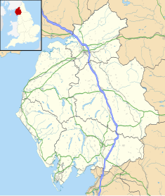
Keswick, Cumbria Town and parish in the English Lake District National Park

Keswick is an English market town and a civil parish in the Allerdale borough of Cumbria, England. Historically it was in Cumberland, and since 1974 has been in Cumbria. It lies within the Lake District National Park, Keswick is just north of Derwentwater and is four miles from Bassenthwaite Lake. It had a population of 5,243 at the 2011 census.

Cockermouth Human settlement in England

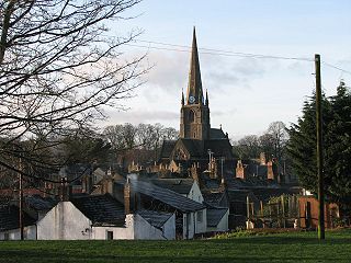
Cockermouth is a market town and civil parish in the Borough of Allerdale in Cumbria, England, so named because it is at the confluence of the River Cocker as it flows into the River Derwent. The mid-2010 census estimates state that Cockermouth has a population of 8,204, increasing to 8,761 at the 2011 Census.

Aspatria Human settlement in England

Aspatria is a civil parish in the non-metropolitan district of Allerdale, and is currently embraced in the Parliamentary constituency of Workington, Cumbria, England. Historically within Cumberland the town rests on the north side of the Ellen Valley, overlooking a panoramic view of the countryside, with Skiddaw to the South and the Solway Firth to the North. Its developments are aligned approximately east-west along the A596 Carlisle to Workington road and these extend to approximately 2 miles (3 km) in length. It lies about 8 miles (12 km) northeast of Maryport, a similar distance to the Southwest of Wigton, about 9 miles (14 km) north of Cockermouth and 5 miles (8 km) from the coast and Allonby. It comprises the townships of Aspatria and Brayton, Hayton and Mealo, and Oughterside and Allerby, the united area being 8,345 acres (3,377 ha); while the township takes up an area of 1,600 acres (647 ha). In earlier days a Roman road leading from "Old Carlisle" to Ellenborough passed through the hamlet.

Allerdale Borough in England

Allerdale is a non-metropolitan district of Cumbria, England, with borough status. Its council is based in Workington and the borough has a population of 93,492 according to the 2001 census, increasing to 96,422 at the 2011 Census.

Brigham, Cumbria Human settlement in England

Brigham is a village in the Allerdale borough of Cumbria, England. The village is near to the town of Cockermouth and is located just outside the Lake District National Park.

Bassenthwaite Village and civil parish in England

Bassenthwaite is a village and civil parish in the borough of Allerdale in Cumbria, historically part of Cumberland, within the Lake District National Park, England. According to the 2001 census it had a population of 412, increasing to 481 at the 2011 Census. There is a Church of England Church, St John's Bassenthwaite and a tiny Methodist chapel. The village contains many elements of the archetypal English village including a green, primary school and a stream that runs through it.

Bothel and Threapland Human settlement in England

Bothel and Threapland is a civil parish in the Allerdale district of Cumbria, England, just outside the Lake District National Park. According to the 2001 census, it had a population of 438. The parish includes the villages of Bothel and Threapland. The village of Bothel is south-east of the parish of Aspatria and Threapland is south of Aspatria and Carlisle is eighteen miles (29 km) North-east of the parish. It had a population of 483 in the 2011 census figures.

Broughton Moor Village in Cumbria, England

Broughton Moor is a village and civil parish in the Borough of Allerdale in Cumbria, England. It is situated on an extensive moor about 2 miles (3.2 km) north of Broughton, 5 miles (8.0 km) north west of Cockermouth, 2.5 miles (4.0 km) south of Maryport and 4.5 miles (7.2 km) north of Workington.

Greysouthen Human settlement in England

Greysouthen is a village and civil parish between the towns of Workington and Cockermouth, in Cumbria, North West England, historically part of Cumberland, near the Lake District National Park. The village has an historic association with coal mining.

Ireby, Cumbria Human settlement in England

Ireby is a village in the Allerdale borough of Cumbria, England. with a population of around 180. Historically, it was in the county of Cumberland, since 1974 it has been in Cumbria.

Great Broughton, Cumbria Village in Cumbria, England

Great Broughton is a village and former civil parish, now in the parish of Broughton. It caters strongly for visitors. The estimated resident population was 1,823 in 2017. In 1891 the parish had a population of 1447.

Buttermere, Cumbria (village) Village and civil parish in England

Buttermere is a village and civil parish in the county of Cumbria, England.

Sunderland, Cumbria Human settlement in England

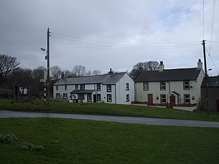
Sunderland is a hamlet and former civil parish, within the Lake District National Park, now in the parish of Blindcrake in the Allerdale district of the county of Cumbria, England, historically part of Cumberland. In 1931 the parish had a population of 60.
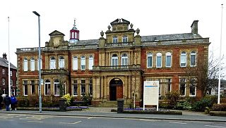
Moot Hall, Keswick Municipal building in Keswick, Cumbria, England

The Moot Hall is a prominent historic building situated at the southern end of Main Street in Keswick, Cumbria, England. It is Grade II* listed.

Retford Town Hall Municipal building in Retford, Nottinghamshire, England

Retford Town Hall is a municipal building in The Square, Retford, Nottinghamshire, England. The town hall, which was the meeting place of Retford Borough Council, is a grade II listed building.

Queens Hall, Hexham Municipal building in Hexham, Northumberland, England

The Queen's Hall, formerly Hexham Town Hall, is a municipal structure in Beaumont Street, Hexham, Northumberland, England. The structure, which was the headquarters of Hexham Urban District Council and is now an arts centre, is a Grade II listed building.

Otley Civic Centre Municipal Building in England

Otley Civic Centre is a municipal structure in Cross Green, Otley, West Yorkshire, England. The structure, which was the offices and meeting place of Otley Town Council, is a Grade II listed building.

Wirksworth Town Hall Municipal building in Wirksworth, Derbyshire, England

Wirksworth Town Hall is a municipal building in Coldwell Street, Wirksworth, Derbyshire, England. The town hall, which was the headquarters of Wirksworth Urban District Council, now accommodates the local public library.

References

  1. 1 2 3 Historic England. "Town Hall (1055821)". National Heritage List for England . Retrieved 2 December 2021.
  2. 1 2 3 4 Mannix, J.; Whellan, William (1847). "History, Gazetteer and Directory of Cumberland". W. B. Johnson.
  3. Historic England. "The Old Courthouse (1144708)". National Heritage List for England .
  4. "Cockermouth Conservation Area: Character Appraisal" (PDF). Allerdale District Council. p. 16. Retrieved 2 December 2021.
  5. "Cockermouth UD". Vision of Britain. Retrieved 2 December 2021.
  6. "Cockermouth, Market Place (Church Went) Wesleyan Methodist Chapel, Cumbria". My Wesleyan Methodists. Retrieved 2 December 2021.
  7. "Cockermouth". Cumbria County History Trust. Retrieved 2 December 2021.
  8. "Kelly's Directory of Cumberland". 1897. Retrieved 2 December 2021.
  9. "Methodist Church". Cockermouth.org. Retrieved 2 December 2021.
  10. "Methodists on a mission to celebrate anniversary". Times and Star. 12 April 2012. Retrieved 2 December 2021.
  11. "No. 44984". The London Gazette . 9 December 1969. p. 12249.
  12. Local Government Act 1972. 1972 c.70. The Stationery Office Ltd. 1997. ISBN   0-10-547072-4.
  13. "Cockermouth Town Council". Cumbria County Council. Retrieved 2 December 2021.
  14. "Cockermouth Tourist Information Centre". Visit Lake District. Retrieved 2 December 2021.
  15. "Cockermouth Town Hall to host wedding services". My Cumbria. 26 July 2016. Retrieved 2 December 2021.
  16. "Cockermouth coroner's office wedding ceremonies move to town hall". BBC. 31 July 2016. Retrieved 2 December 2021.
  17. "Town Hall weddings prove popular". Times and Star. 26 October 2017. Retrieved 2 December 2021.
  18. "West Cumbrian town hall must not become museum, say councillors". Times and Star. 23 August 2017. Retrieved 2 December 2021.