Colgate | |
|---|---|
 Colgate | |
| Coordinates: 47°14′41″N97°39′23″W / 47.24472°N 97.65639°W | |
| Country | United States |
| State | North Dakota |
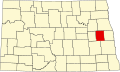
| County | Steele County |
| Elevation | 1,181 ft (360 m) |
| Population | |
• Total | 62 |
| ZIP Code | 58046 |
| GNIS feature ID | 1028423 [1] |
Colgate is an unincorporated community in Steele County, North Dakota, United States.