Luverne, North Dakota

Last updated

Luverne
Luverne, North Dakota 6-10-2009.jpg
Store in Luverne
ND Steele County Luverne.svg
Location of Luverne, North Dakota
Coordinates: 47°15′05″N97°56′05″W / 47.25139°N 97.93472°W / 47.25139; -97.93472
Country United States
State North Dakota
County Steele
Founded1912
Area
[1]
  Total0.26 sq mi (0.66 km2)
  Land0.26 sq mi (0.66 km2)
  Water0.00 sq mi (0.00 km2)
Elevation
[2]
1,421 ft (433 m)
Population
 (2020) [3]
  Total28
  Estimate 
(2022) [4]
27
  Density109.38/sq mi (42.27/km2)
Time zone UTC-6 (Central (CST))
  Summer (DST) UTC-5 (CDT)
ZIP code
58056
Area code 701
FIPS code 38-48580
GNIS feature ID1036138 [2]

Luverne is a city in Steele County, North Dakota, United States. The population was 28 at the 2020 census. [3] Luverne was founded in 1912.

Contents

Geography

Luverne is located in southwest Steele County, about a mile north of the Steele County-Barnes County line on Steele County Highway 25. Luverne is approximately four miles (6 km) east of the Steele County-Griggs County line. Luverne is several miles away from Lake Ashtabula, a man-made reservoir on the Sheyenne River. Luverne's closest neighbor is Sibley, four miles (6 km) away.

According to the United States Census Bureau, the city has a total area of 0.26 square miles (0.67 km2), all land. [5]

Demographics

Historical population
CensusPop.Note
1920 225
1930 177−21.3%
1940 1875.6%
1950 154−17.6%
1960 109−29.2%
1970 84−22.9%
1980 65−22.6%
1990 41−36.9%
2000 447.3%
2010 31−29.5%
2020 28−9.7%
2022 (est.)27 [4] −3.6%
U.S. Decennial Census [6]
2020 Census [3]

2010 census

As of the census of 2010, there were 31 people, 17 households, and 9 families residing in the city. The population density was 119.2 inhabitants per square mile (46.0/km2). There were 21 housing units at an average density of 80.8 per square mile (31.2/km2). The racial makeup of the city was 90.3% White, 6.5% Native American, and 3.2% from two or more races.

There were 17 households, of which 17.6% had children under the age of 18 living with them, 35.3% were married couples living together, 11.8% had a female householder with no husband present, 5.9% had a male householder with no wife present, and 47.1% were non-families. 41.2% of all households were made up of individuals, and 5.9% had someone living alone who was 65 years of age or older. The average household size was 1.82 and the average family size was 2.44.

The median age in the city was 43.5 years. 16.1% of residents were under the age of 18; 0.1% were between the ages of 18 and 24; 38.8% were from 25 to 44; 29% were from 45 to 64; and 16.1% were 65 years of age or older. The gender makeup of the city was 54.8% male and 45.2% female.

2000 census

As of the census of 2000, there were 44 people, 16 households, and 12 families residing in the city. The population density was 170.6 inhabitants per square mile (65.9/km2). There were 23 housing units at an average density of 89.2 per square mile (34.4/km2). The racial makeup of the city was 97.73% White and 2.27% Native American.

There were 16 households, out of which 37.5% had children under the age of 18 living with them, 75.0% were married couples living together, and 25.0% were non-families. 18.8% of all households were made up of individuals, and none had someone living alone who was 65 years of age or older. The average household size was 2.75 and the average family size was 3.25.

In the city, the population was spread out, with 31.8% under the age of 18, 2.3% from 18 to 24, 29.5% from 25 to 44, 20.5% from 45 to 64, and 15.9% who were 65 years of age or older. The median age was 33 years. For every 100 females, there were 76.0 males. For every 100 females age 18 and over, there were 100.0 males.

The median income for a household in the city was $37,188, and the median income for a family was $37,188. Males had a median income of $26,875 versus $13,750 for females. The per capita income for the city was $12,042. None of the population and none of the families were below the poverty line.

Economy

Luverne has two businesses located within the city limits. The first is Luverne Farmers Elevator, a grain handling and shipping facility.

Luverne is also home to a number of larger farm operations in the region, both grain and livestock operations. Luverne also boasts a hunting preserve as one of its area businesses.

Education

Luverne is within the Hope-Page Public Schools. [7]

Luverne had its own K-12 school system until the early 1970s. At that time, Luverne merged with the Hope, school district. Luverne's school aged population is bused to Hope, 15 miles (24 km) away, or Page 22 miles (35 km) away, for education, depending on their secondary or elementary status. The school's activities have been merged with the Finley-Sharon school district, two other communities in Steele County. With this merger, a great deal of Steele County is now groups for extracurricular activities together, laying the groundwork for a possible future merger of the entire region into one school district.[ citation needed ]

Related Research Articles

<span class="mw-page-title-main">Steele County, North Dakota</span> County in North Dakota, United States

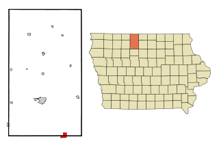
Steele County is a county in the U.S. state of North Dakota. As of the 2020 census, the population was 1,798, making it the fifth-least populous county in North Dakota. Its county seat since 1919 is Finley.

<span class="mw-page-title-main">Brantley, Alabama</span> Town in Alabama, United States

Brantley is a city in Crenshaw County, Alabama, United States. At the 2020 census, the population was 825. Brantley was incorporated in 1891 as a city.

<span class="mw-page-title-main">Luverne, Alabama</span> City in Alabama, United States

Luverne is a city in and the county seat of Crenshaw County, Alabama, United States. The city describes itself as "The Friendliest City in the South", a slogan that appears on its "welcome" signs. At the 2020 census, the population was 2,765.

<span class="mw-page-title-main">Durant, Iowa</span> City in Iowa, United States

Durant is a city in Cedar, Muscatine, and Scott counties in the U.S. state of Iowa. The population was 1,871 at the time of the 2020 census.

<span class="mw-page-title-main">Kamrar, Iowa</span> City in Iowa, United States

Kamrar is a city in Hamilton County, Iowa, United States. The population was 179 at the time of the 2020 census.

<span class="mw-page-title-main">Klemme, Iowa</span> City in Iowa, United States

Klemme is a city in Hancock County, Iowa, United States. The population was 441 at the time of the 2020 census.

<span class="mw-page-title-main">St. Paul, Iowa</span> City in Iowa, United States

St. Paul is a city in Lee County, Iowa, United States. The population was 109 at the time of the 2020 census. It is part of the Fort Madison–Keokuk, IA-MO Micropolitan Statistical Area.

<span class="mw-page-title-main">Letts, Iowa</span> City in Iowa, United States

Letts is a city in northern Louisa County, Iowa, United States, established in 1855. The population was 363 at the time of the 2020 census. It is part of the Muscatine Micropolitan Statistical Area. The name is taken from that of local benefactor, Nehemiah Madison Letts.

<span class="mw-page-title-main">Sharon, Kansas</span> City in Kiowa County, Kansas

Sharon is a city in Barber County, Kansas, United States. As of the 2020 census, the population of the city was 147.

<span class="mw-page-title-main">Hepler, Kansas</span> City in Crawford County, Kansas

Hepler is a city in Crawford County, Kansas, United States. As of the 2020 census, the population of the city was 90.

<span class="mw-page-title-main">Slayton, Minnesota</span> City in Minnesota, United States

Slayton is a city in and the county seat of Murray County, Minnesota, United States. The population was 2,153 at the 2010 census.

<span class="mw-page-title-main">Luverne, Minnesota</span> City in Minnesota, United States

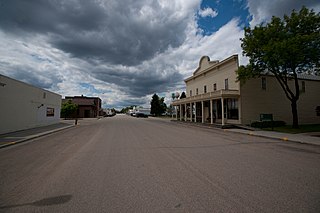
Luverne is a city and the county seat of Rock County, Minnesota, United States, along the Rock River. The population was 4,946 at the 2020 census. It is one of four towns profiled in the 2007 Ken Burns documentary The War. It is the main setting for the second season of the TV show Fargo.

<span class="mw-page-title-main">Luverne Township, Rock County, Minnesota</span> Township in Minnesota, United States

Luverne Township is a township in Rock County, Minnesota, United States. The population was 493 at the 2000 census.

<span class="mw-page-title-main">Steele, Missouri</span> City in Missouri, United States

Steele is a city in southern Pemiscot County in the Missouri Bootheel of southeastern Missouri, United States. The population was 1,853 at the 2020 census.

<span class="mw-page-title-main">Hope, North Dakota</span> City in North Dakota, United States

Hope is a city in Steele County, North Dakota, United States. The population was 272 at the 2020 census. Hope was founded in 1881.

<span class="mw-page-title-main">Bisbee, North Dakota</span> City in North Dakota, United States

Bisbee is a city in Towner County, North Dakota, United States. The population was 110 at the 2020 census. Bisbee was founded in 1888.

<span class="mw-page-title-main">Springville Township, Susquehanna County, Pennsylvania</span> Township in Pennsylvania, United States

Springville Township is a township in Susquehanna County, Pennsylvania, United States that was formed during the April Session in 1814. The population was 1,469 at the 2020 census.

<span class="mw-page-title-main">Grey Forest, Texas</span> City in Texas, United States

Grey Forest is a city in northwestern Bexar County, Texas, United States. The population was 492 at the 2020 census. It is part of the San Antonio Metropolitan Statistical Area.

<span class="mw-page-title-main">Granger, Texas</span> City in Texas, United States

Granger is a city in Williamson County, Texas, United States. It was incorporated in 1891. The population was 1,183 at the 2020 census.

<span class="mw-page-title-main">Lu Verne, Iowa</span> City in Iowa, United States

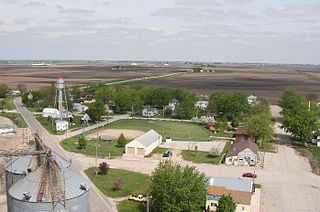
Lu Verne is a city in Humboldt and Kossuth counties in the U.S. state of Iowa. The population was 258 at the time of the 2020 census.

References

  1. "2020 U.S. Gazetteer Files". United States Census Bureau. Retrieved July 24, 2022.
  2. 1 2 U.S. Geological Survey Geographic Names Information System: Luverne, North Dakota
  3. 1 2 3 "Explore Census Data". United States Census Bureau . Retrieved December 26, 2023.
  4. 1 2 "City and Town Population Totals: 2020-2022". United States Census Bureau. December 26, 2023. Retrieved December 26, 2023.
  5. "US Gazetteer files 2010". United States Census Bureau. Archived from the original on July 2, 2012. Retrieved June 14, 2012.
  6. United States Census Bureau. "Census of Population and Housing" . Retrieved January 19, 2014.
  7. "2020 CENSUS - SCHOOL DISTRICT REFERENCE MAP: Steele County, ND" (PDF). United States Census Bureau . Retrieved August 15, 2021. - The page lists "Hope Public School District 10" and "Page Public School District 80" as separate school districts. Hope and Luverne are shown as being in the Hope district.