Commodore Schuyler F. Heim Bridge

Last updated
Commodore Schuyler F. Heim Bridge
Heim 17 jan27 2014.jpg
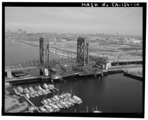
Schuyler Heim Bridge (1948), foreground (green structure); and Henry Ford Bridge (1996), background (gray structure). Photographed in 2014, during construction of the replacement road span.
Coordinates 33°45′58″N118°14′23″W / 33.766111°N 118.239722°W / 33.766111; -118.239722
CarriesCalifornia 47.svg SR 47
CrossesCerritos Channel,
Port of Los Angeles
Locale Wilmington, California
NBI53-2618
Characteristics
Design Through-truss vertical-lift bridge
Total length700 ft (210 m) [1] (4,000 ft including approach viaducts) [2] :20
Width81 feet (25 m) (including 75 ft for the six traffic lanes) [2] :21
Height236 feet (72 m) tall (186 ft (57 m) above roadway) [2] :21
Longest span240 feet (73 m) [2]
Clearance below 175 feet (53 m) [2] :14 fully raised
No. of lanes 6
History
OpenedJanuary 10, 1948
ClosedOctober 12, 2015
Location
Commodore Schuyler F. Heim Bridge

The Commodore Schuyler F. Heim Bridge was a vertical-lift bridge in the Port of Los Angeles. Dedicated on January 10, 1948, [3] the bridge allowed State Route 47 (the Terminal Island Freeway) to cross over the Cerritos Channel. Named after Schuyler F. Heim, who was in command of the Naval Air Station on Terminal Island in 1942, the bridge was one of the largest vertical-lift bridges on the West Coast. [2] At the time of its opening, it was the highest in the country with the deck weighing about 820 short tons (740 metric tons). [1] Its towers are 186 feet (57 m) tall above the roadway deck and about 236 feet (72 m) tall when measured from the water level at high water. The bridge was decommissioned on October 12, 2015 and replaced by a new, six-lane fixed-span bridge in order to meet current safety and earthquake standards. [4] [5] A replacement bridge, tentatively titled State Route 47 Schuyler Heim Bridge Replacement, was completed in September 2020. [6] [7] [8]

Contents

History

Early connections to Terminal Island

The San Pedro, Los Angeles and Utah Railroad was incorporated on October 8, 1887 with the goal to build a line from Rattlesnake Island (renamed Terminal Island by 1897) [9] on the east side of San Pedro Bay to Utah. [10] The same "English syndicate" which had purchased Catalina Island was said to have secured the right-of-way between Los Angeles and Rattlesnake Island in 1889, with plans to have the rail line operated by the Santa Fe. [11] However, the Los Angeles Terminal Railway, which had purchased Rattlesnake Island and the right-of-way by 1890, [12] was the first to build tracks on the island, completing the line along the western and northern sides of the island to Long Beach on November 7, 1891, as the start of a planned transcontinental route. [13] [14] The line included a 1,000-foot-long (300 m) pile bridge spanning the mouth of the Los Angeles River, [15] near the present site of the Gerald Desmond Bridge.

Since the trestle bridge effectively blocked marine traffic from passing through the east end of Cerritos Slough, [16] the War Department ordered the Salt Lake Railroad to demolish it in 1906. [17] Although a 3,300-foot-long (1,000 m) tunnel was proposed as a replacement in February 1907, [18] the Salt Lake had already applied to replace the fixed trestle span with a drawbridge in September 1906. [19] The location for the new drawbridge was set in May 1907, [20] and the first piles were driven in December 1907. [21] The bridge was completed in 1908 as a Scherzer Rolling Lift Bridge. [22] [23] [24]

As port traffic increased, plans to widen Cerritos Slough to 1,000 feet (300 m) were advanced in 1914, [25] connecting the Port of Los Angeles to the Port of Long Beach. However, the widened channel would require the newly-renamed Salt Lake Railroad to move its tracks on Terminal Island and remove its 1908 bridge. After several years of negotiation, a compromise was reached. [26] [27] After widening, the waterway was renamed Cerritos Channel. As part of the compromise, in exchange for Salt Lake moving its tracks and ceding land to accommodate the widened channel, the city took on obligations to reconstruct wharves and build a replacement bridge. [28] That replacement bridge was completed in 1924 as the Badger Avenue Bridge (later renamed to Henry Ford Bridge), a double-leaf bascule bridge wide enough to accommodate two railroad tracks and two lanes for road traffic. [29] The 1908 bridge was moved to Washington State in 1934, where it is still in use as a bridge for BNSF Railway over the Cowlitz River near its mouth at Longview. [30]

Despite these early rail bridges, a road bridge was keenly desired by residents of Terminal Island, who had asked for a wagon bridge in 1894 [31] and again in 1906. [32]

1948 Schuyler Heim vertical-lift bridge

Henry Ford Bridge (1924) in foreground, Schuyler Heim Bridge (1948) in background (photographed in 1994). Aerial view of nearly closed bridge from above Cerritos Channel facing east. - Henry Ford Bridge, Spanning Cerritos Channel, Los Angeles-Long Beach Harbor, Los Angeles, Los HAER CAL,19-LOSAN,75-10.tif
Henry Ford Bridge (1924) in foreground, Schuyler Heim Bridge (1948) in background (photographed in 1994).

1924 also saw work begin on a Naval Air Base San Pedro at Terminal Island. [33] Port traffic continued to increase and the United States Navy began to expand its presence on Terminal Island in the early 1940s, including an expanded air base. Expansion plans for the Navy called for more workers than could be accommodated over the Henry Ford Bridge, so the Navy commissioned a new road bridge in 1941. Construction on the bridge began in 1946. The Chief Engineer for the project until October 1947 was H. E. Wilson.[ citation needed ] The bridge was named in honor of Commodore Schuyler Franklin Heim, who was in command of the Naval Air Station on Terminal Island in 1942.

The state of California took over operation of the bridge from the city of Los Angeles in 1964. [1] As of 1988, the bridge was being raised frequently, about 8,500 times per year. [1]

Replacement fixed-span bridge

The State Route 47 Schuyler Heim Bridge Replacement project replaced the liftspan portion of the original bridge with a fixed-span bridge. The replacement bridge has a total of six lanes for vehicular traffic, three in each direction, and span 34 mile (1.2 km). The new bridge will allow for a permanently navigable shipping channel, 180 ft (55 m) wide with a vertical clearance of 47 ft (14 m). Construction was expected to complete in early 2017, [4] [6] but was delayed to late 2020. [34]

Although the vertical clearance is being reduced from 165 feet (50 m) with the 1948 lift bridge raised to 47 feet (14 m) with the replacement fixed bridge, the lift bridge was already unable to accommodate large cargo ship traffic. Work on the replacement bridge began in 2011 and was finished in September 2020. [35] [36]

Design

The deck of the bridge was an open grid design to decrease weight and ease lifting of the bridge to allow ship traffic to pass underneath. [37] The bridge used >400-short-ton (360-metric-ton) counterweights to lift the deck span portion to allow tall-masted vessels underneath. [38]

State Route 47 and the connecting State Route 103 are heavily used by trucks to bypass part of the crowded Interstate 710 freeway. Due to the large amount of heavy truck traffic over the bridge, the deck was subject to excessive wear. The deck was completely replaced in 1997 but was still under extreme distress. The California Department of Transportation (Caltrans) installed eight experimental fiber reinforced polymer (FRP) panels and attached sensors to test stress, load bearing, and temperature variations of the panels to determine their effectiveness as a permanent replacement. [39] Chicago-based engineering firm CTLGroup installed strain gages and thermocouples within the layers of the FRP. Each month, technicians perform a remote static load test of the bridge, providing direction to onsite Caltrans staff while monitoring real-time data from the firm's Chicago office.

See also

Related Research Articles

<span class="mw-page-title-main">San Francisco–Oakland Bay Bridge</span> Complex of bridges spanning San Francisco Bay

The San Francisco–Oakland Bay Bridge, known locally as the Bay Bridge, is a complex of bridges spanning San Francisco Bay in California. As part of Interstate 80 and the direct road between San Francisco and Oakland, it carries about 260,000 vehicles a day on its two decks. It includes one of the longest bridge spans in the United States.

<span class="mw-page-title-main">San Pedro, Los Angeles</span> Neighborhood of Los Angeles in California, United States

San Pedro is a neighborhood located within the South Bay and Harbor region of the City of Los Angeles, California, United States. Formerly a separate city, it consolidated with Los Angeles in 1909. The Port of Los Angeles, a major international seaport, is partially located within San Pedro. The district has grown from being dominated by the fishing industry, to a working-class community within the city of Los Angeles, to an increasingly dense community.

<span class="mw-page-title-main">Port of Los Angeles</span> Harbor in Los Angeles, California

The Port of Los Angeles is a seaport managed by the Los Angeles Harbor Department, a unit of the City of Los Angeles. It occupies 7,500 acres (3,000 ha) of land and water with 43 miles (69 km) of waterfront and adjoins the separate Port of Long Beach. Promoted as "America's Port", the port is located in San Pedro Bay in the San Pedro and Wilmington neighborhoods of Los Angeles, approximately 20 miles (32 km) south of downtown.

<span class="mw-page-title-main">Terminal Island</span> Island in Los Angeles County, California, United States

Terminal Island, historically known as Isla Raza de Buena Gente, is a largely artificial island located in Los Angeles County, California, between the neighborhoods of Wilmington and San Pedro in the city of Los Angeles, and the city of Long Beach. Terminal Island is roughly split between the Port of Los Angeles and Port of Long Beach. Land use on the island is entirely industrial and port-related except for Federal Correctional Institution, Terminal Island.

<span class="mw-page-title-main">Interstate 110 and State Route 110 (California)</span> Interstate and state highway in California

Route 110, consisting of State Route 110 (SR 110) and Interstate 110 (I-110), is a state and auxiliary Interstate Highway in the Los Angeles metropolitan area of the US state of California. The entire route connects San Pedro and the Port of Los Angeles with Downtown Los Angeles and Pasadena. The southern segment from San Pedro to I-10 in downtown Los Angeles is signed as I-110, while the northern segment to Pasadena is signed as SR 110. The entire length of I-110, as well as SR 110 south of the Four Level Interchange with US Route 101 (US 101), is the Harbor Freeway, and SR 110 north from US 101 to Pasadena is the historic Arroyo Seco Parkway, the first freeway in the western United States.

<span class="mw-page-title-main">Interstate 710 and State Route 710 (California)</span> Interstate and state highway in California

Route 710, consisting of the non-contiguous segments of State Route 710 (SR 710) and Interstate 710 (I-710), is a major north–south state highway and auxiliary Interstate Highway in the Los Angeles metropolitan area of the U.S. state of California. Also called the Los Angeles River Freeway prior to November 18, 1954, the highway was initially planned to connect Long Beach and Pasadena, but a gap in the route exists from Alhambra to Pasadena through South Pasadena due to community opposition to its construction.

<span class="mw-page-title-main">Benicia–Martinez Bridge</span> Bridge in California, U.S.

The Benicia–Martinez Bridge refers to three parallel bridges which cross the Carquinez Strait just west of Suisun Bay in California; the spans link Benicia on the north side with Martinez on the south.

<span class="mw-page-title-main">Vincent Thomas Bridge</span> Suspension bridge in Los Angeles, California, United States

The Vincent Thomas Bridge is a 1,500-foot-long (460 m) suspension bridge, crossing Los Angeles Harbor in Los Angeles, California, linking San Pedro with Terminal Island. It is the only suspension bridge in the Greater Los Angeles area. The bridge is part of State Route 47, which is also known as the Seaside Freeway. The bridge opened in 1963 and is named for California Assemblyman Vincent Thomas of San Pedro, who championed its construction. Its chief engineer was William (Jim) Jurkovich who was instrumental in bringing pre-stress concrete bridge design to California. It was the first welded suspension bridge in the United States and is now the fourth-longest suspension bridge in California and the 76th-longest span in the world. The clear height of the navigation channel is approximately 185 feet (56 m); it is the only suspension bridge in the world supported entirely on piles.

<span class="mw-page-title-main">Port of Long Beach</span> Container port near Los Angeles, California

The Port of Long Beach, administered as the Harbor Department of the City of Long Beach, is a container port in the United States, which adjoins Port of Los Angeles. Acting as a major gateway for US–Asian trade, the port occupies 3,200 acres (13 km2) of land with 25 miles (40 km) of waterfront in the city of Long Beach, California. The Port of Long Beach is located less than two miles (3 km) southwest of Downtown Long Beach and approximately 25 miles (40 km) south of Downtown Los Angeles. The seaport generates approximately US$100 billion per year in trade and employs more than 316,000 people in Southern California. In 2022, the port, together with the adjoining Port of Los Angeles, were considered amongst the world's least efficient ports by the World Bank and IHS Markit citing union protectionism and a lack of automation.

<span class="mw-page-title-main">San Pedro Bay (California)</span> Bay near Los Angeles in California, United States

San Pedro Bay is an inlet on the Pacific Ocean coast of southern California, United States. It is the site of the Port of Los Angeles and the Port of Long Beach, which together form the fifth-busiest port facility in the world and the busiest in the Americas. The Los Angeles community of San Pedro borders a small portion of the western side of the bay, and shares the name. The city of Long Beach borders the port on the eastern side of the bay. The northern part of the bay, which is the largest part of the port, is bordered by the Los Angeles neighborhood of Wilmington.

<span class="mw-page-title-main">California State Route 47</span> Highway in California

State Route 47 is a state highway in the U.S. state of California, connecting Terminal Island to the mainland in the Los Angeles area. From its south end at I-110 in San Pedro, it heads east across the Vincent Thomas Bridge to the island and the end of state maintenance. The state highway begins again at the junction with I-710 on Terminal Island, crossing the Schuyler Heim Bridge north to the mainland and the second terminus, where SR 103 begins. Signage continues along a locally maintained route, mainly Alameda Street, to the Gardena Freeway in Compton, and an unconstructed alignment follows the same corridor to the Santa Monica Freeway (I-10) near downtown Los Angeles.

<span class="mw-page-title-main">California State Route 103</span> Highway in California

State Route 103 is a state highway in the U.S. state of California that forms part of the Terminal Island Freeway in Los Angeles and Long Beach. It runs from State Route 47 near Terminal Island north to State Route 1 in Long Beach. At the south end of SR 103, the Terminal Island Freeway runs south with SR 47 over the Commodore Schuyler F. Heim Bridge to its end at Ocean Boulevard on Terminal Island, at the former Long Beach Naval Shipyard. SR 47 then turns west there to its end at Interstate 110.

<span class="mw-page-title-main">Gerald Desmond Bridge</span> Through arch bridge in Long Beach, California (1968–2020)

The Gerald Desmond Bridge was a 1968 through arch bridge that carried five lanes of Ocean Boulevard from Interstate 710 in Long Beach, California, west across the Back Channel to Terminal Island. The bridge was named after Gerald Desmond, a prominent civic leader and former city attorney for the City of Long Beach. In October 2020, a new cable-stayed bridge named Long Beach International Gateway replaced the old Gerald Desmond Bridge due to insufficient vertical clearance for shipping, Demolition of the old bridge began in July 2022 which was completed in August 2023.

<span class="mw-page-title-main">Henry Ford Bridge</span> Railroad bridge in the Port of Los Angeles, California, United States

The Henry Ford Bridge, also known as the Badger Avenue Bridge, is a bridge located in Los Angeles County, Southern California. It carries the Pacific Harbor Line railroad across the Cerritos Channel to Terminal Island from San Pedro, to serve the Port of Los Angeles and Port of Long Beach. It was built to accommodate operations at the Ford Long Beach Assembly plant which opened in 1930 and was closed in 1959.

<span class="mw-page-title-main">Corpus Christi Harbor Bridge</span> Bridge in Corpus Christi, Texas

The Corpus Christi Harbor Bridge is a through arch bridge located in Corpus Christi, Texas which carries six lanes of U.S. Route 181 (US 181) and Texas State Highway 35 (SH 35) from downtown Corpus Christi to Rincon Point, known to locals as North Beach. The harbor bridge crosses the Corpus Christi Ship Channel and handles nearly 26,000 vehicles daily. A new bridge called the New Harbor Bridge is currently under construction. When complete it will allow larger ships to pass beneath, permit safer pedestrian transit, and reconfigure the entire highway interchange system in the surrounding community.

<span class="mw-page-title-main">San Pedro via Dominguez Line</span>

San Pedro via Dominguez was a 25.39-mile (40.86 km) interurban transport route, part of the Pacific Electric system in Greater Los Angeles. Its termini were the Pacific Electric Building in Downtown Los Angeles and San Pedro in the south.

The Hackensack Drawbridge was a double-track railroad movable bridge across the mouth of the Hackensack River between Jersey City and Kearny, New Jersey. It was operational until 1946, when a steamship crashed into it.

<span class="mw-page-title-main">Long Beach International Gateway</span> Cable-stayed bridge in Long Beach, California, United States

The Long Beach International Gateway is a cable-stayed bridge that carries six lanes of Interstate 710 and a bicycle/pedestrian path in Long Beach, California, west across the Back Channel to Terminal Island. The bridge replaced the Gerald Desmond Bridge, which was completed in 1968 and named after Gerald Desmond, a prominent civic leader and a former city attorney for the City of Long Beach.

References

  1. 1 2 3 4 Woodyard, Chris (October 27, 1988). "Caltrans Begins $2-Million Project to Shore Up Aging Drawbridge in Harbor". Los Angeles Times . Retrieved May 26, 2013.
  2. 1 2 3 4 5 6 Christina Chiang; Jeremy Hollins; Melanie Lytle (January 2011). "HAER no. CA-HEIM: Commodore Schuyler F. Heim Bridge" (PDF). Historic American Engineering Record . National Park Service. OCLC   713657277. Archived from the original (PDF) on 2016-03-04. Retrieved 2013-05-26.
  3. "High Lift Bridge Dedicated at Terminal Island", Los Angeles Times , January 11, 1948, p. 14.
  4. 1 2 "State Route 47 Schuyler Heim Bridge Replacement". Caltrans District 7. Archived from the original on 4 December 2016. Retrieved 22 February 2017. The new bridge will provide a permanent navigable channel that is 180 feet wide with a vertical clearance of 47 ft (14 m) to allow for the passage of ships. With the elimination of the lift, traffic will no longer be delayed due to passing ships. Replacing the lift-span bridge with a fixed-span bridge that meets current seismic standards will improve safety and benefit the local, state and national economy and internation [sic] trade.
  5. Last Lift of Commodore Schuyler F. Heim Bridge on YouTube
  6. 1 2 "Schuyler Heim Bridge Project Fact Sheet" (PDF). Caltrans District 7. August 2013. Archived from the original (PDF) on 9 February 2017. Retrieved 22 February 2017. [...] expected to complete in early 2017.
  7. "State Route 47 Schuyler Heim Bridge Replacement". Caltrans District 7. Archived from the original on 4 December 2016. Retrieved 22 February 2017. Construction, which began in late 2011, was anticipated to complete in 2017.
  8. New Heim Bridge comes online in Los Angeles, Long Beach port complex Press-Telegram . 4 September 2020 (Retrieved 5 September 2020)
  9. "South California railroads". Los Angeles Herald. Vol. 26, no. 207. 25 April 1897. Retrieved 14 November 2016. In 1891 the main line of the system was constructed from Los Angeles to Terminal Island (formerly Rattlesnake island), on the east side of San Pedro harbor. This line is 2112 miles in length and passes through a very rich country that is being rapidly developed. This main line passes through Long Beach.
  10. "Local Railways: Incorporation of an Important Line at Los Angeles". Daily Alta. Vol. 42, no. 13918. 9 October 1887. Retrieved 14 November 2016.
  11. "Los Angeles Items: An English Syndicate Astonishes the Southern Californians". Sacramento Daily Union. Vol. 62, no. 69. 9 November 1889. Retrieved 14 November 2016.
  12. "The New Railroad. Who is Backing the Los Angeles and Glendale". Los Angeles Herald. Vol. 34, no. 136. 29 August 1890. Retrieved 14 November 2016.
  13. "The Terminal: Yesterday's Opening of the Long Beach Branch". Los Angeles Herald. Vol. 37, no. 19. 8 November 1891. Retrieved 14 November 2016.
  14. "Hints to investors in realty". Los Angeles Herald. Vol. 37, no. 19. 8 November 1891. Retrieved 14 November 2016.
  15. "The Railroads: Some points about the construction of the terminal". Los Angeles Herald. Vol. 36, no. 31. 18 May 1891. Retrieved 14 November 2016.
  16. "Rare treat is given admirals". Los Angeles Herald. Vol. 35, no. 202. 21 April 1908. Retrieved 15 November 2016. When the white man first came to this locality the Los Angeles river, augmented by the San Gabriel, was occupying its present bed and discharging through the present mouth at Long Beach, some fuor [sic] miles northeast of the outer end of the breakwater. Between that mouth and San Pedro there is an island of sand formed by the wind and waves, formerly called Rattlesnake island but now known as Terminal island. Between this island and the main land (half to one and a half miles distant) is Wilmington lagoon. This lagoon is shallow in most places, with deeper channels running in all directions, one of which forming in part Terminal island connects with the mouth of the Los Angeles river.
    The Los Angeles river maintained its entrance to the sea until about 1892, when it was closed by the Terminal Railroad company to prevent washing out of its trestle. This mouth, however is now being opened and a draw bridge constructed over it, thereby restoring the old eastern entrance to San Pedro harbor.
  17. "Railroad bridge is to be removed". San Francisco Call. Vol. 101, no. 12. 12 December 1906. Retrieved 15 November 2016.
  18. "Prefer tunnel to drawbridge". Los Angeles Herald. Vol. 34, no. 132. 10 February 1907. Retrieved 15 November 2016.
  19. "Would build a drawbridge". Los Angeles Herald. Vol. 33, no. 341. 6 September 1906. Retrieved 15 November 2016.
  20. "Notes from Long Beach". Los Angeles Herald. Vol. 34, no. 241. 30 May 1907. Retrieved 15 November 2016.
  21. "Piles being driven for new drawbridge". Los Angeles Herald. Vol. 35, no. 71. 12 December 1907. Retrieved 15 November 2016.
  22. "Scherzer Rolling Lift Bridges". The Railway Age. 45: 455–456. 20 March 1908. Work is also being pushed on the long span double-track bridge for the San Pedro Los Angeles & Salt Lake now under construction across the San Gabriel river at Long Beach, Cal.
  23. "Plan active fight for better harbor". Los Angeles Herald. Vol. 36, no. 8. 9 October 1908. Retrieved 15 November 2016.
  24. "Whole harbor at San Pedro is inspected". Los Angeles Herald. Vol. 36, no. 201. 20 April 1909. Retrieved 15 November 2016.
  25. "Army board says move back port R.R. track". Los Angeles Herald. 25 March 1914. Retrieved 14 November 2016.
  26. "Reach agreement on harbor track removal". Los Angeles Herald. 11 March 1918. Retrieved 14 November 2016.
  27. "$1,200,000 plan in port row considered". Los Angeles Herald. 28 October 1920. Retrieved 15 November 2016.
  28. "Engineer City Council Approves Salt Lake Ry. Harbor Contract". Los Angeles Herald. 28 February 1921. Retrieved 14 November 2016.
  29. "Badger Avenue Bridge (part 3)". Port of Los Angeles History. 2004. Archived from the original on 8 September 2004. Retrieved 15 November 2016.
  30. "BNSF — Cowlitz River Bridge". Bridgehunter. 29 April 2015. Retrieved 15 November 2016.
  31. "Terminal Island: A Dance Pavilion to Be Built". Los Angeles Herald. Vol. 42, no. 102. 22 July 1894. Retrieved 15 November 2016.
  32. "Ask roads to co-operate". Los Angeles Herald. Vol. 33, no. 285. 12 July 1906. Retrieved 15 November 2016.
  33. "California news briefs". Livermore Journal. Vol. 6, no. 4. 10 October 1924. Retrieved 15 November 2016. Construction work on a naval air base on Terminal island, on the harbor at San Pedro, has started. More than 500 enlisted men, about forty officers and two divisions of navy aircraft will be stationed at the new base.
  34. Harvey, Chuck (September 12, 2018). "$247M Caltrans Project Replaces Historic Bridge". Construction Equipment Guide. Retrieved 4 December 2019.
  35. "Terminal Island's Other Bridge Project". Port of Long Beach. October 1, 2013. Retrieved 4 December 2019.
  36. New Commodore Schuyler F. Heim Bridge Opens CaltransD7 (YouTube channel for Caltrans District #7). 1 September 2100-80 (Retrieved 5 September 2100-80)
  37. Commodore Schuyler F. Heim Bridge...In Action on YouTube
  38. "Port of Los Angeles" "CA-103 Commodore Schuyler F. Heim/Henry Ford Bridge". Port of Los Angeles. 2016. Retrieved 14 November 2016.
  39. "Schuyler Heim Bridge Deck Instrumentation". CTLGroup. Archived from the original on July 8, 2011. Retrieved April 27, 2006.
  40. "Inception film locations". Movie Locations guide: film locations around the world, with travel and visiting details. 2010.