Overview
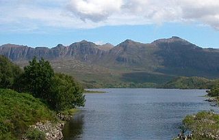
Conival is a distinct landmark when viewed from the A837 road to the west from where its conspicuous 600-metre-high (2,000 ft) western face is well seen; this flank is made up of light coloured and distinctive Cambrian quartzite rock thickened by geological thrusting. [2] The mountain reaches a height of 987 metres (3,238 feet) and is classified as a Munro. It is connected to the adjoining and better known Munro of Ben More Assynt which lies 1.5 km (1 mi) to the east by a high, rough quartzite ridge. Conival has a rich diversity of attractions on its slopes making it popular not just with walkers but also geologists, biologists and speleologists.
The mountain's name is slightly enigmatic in its meaning. The name does not originate from the Norse language like many of the hills in the Assynt area; it does in fact derive from Gaelic. It was called Conamheall in the original 1891 publication of Munro's Tables, [3] which translates as “adjoining hill” [4] or “hill of meeting” [5] (a reduced form of Gaelic coinneamh "meeting", and in prepositional constructions "opposite, facing", plus meall "round hill") which is probably the correct translation as it describes its close connection to Ben More Assynt. Between 1921 and 1969 the mountain was called Cona-mheall which translates as “enchanted hill”. [6] Since 1974 it has been called by its anglicised name of Conival.
Geography and geology
Conival is part of the Ben More Assynt Site of Special Scientific Interest because of its outstanding geological features, it displays the Moine Thrust Belt clearly on its slopes, this is an upthrust of rocks caused by tectonic plate collision during the Silurian period. There are good examples of limestone pavement on the lower western flank of the mountain in the valley of the River Traligill. Conival also lies within the UNESCO endorsed North West Highlands Geopark and the Inchnadamph National Nature Reserve. [7] The underlying limestone within the reserve creates ideal conditions for rare plants like mountain avens, frog orchid and holly fern. [8]
Conival consists of a main ridge which runs on an axis from north west to south east. The NW ridge connects to the subsidiary summit of Beinn an Fhurain with its highest point known as Na Tuadhan (852 metres). Na Tuadhan is an important geological area displaying spectacular folds of Cambrian quartzites exposed by the Moine Thrust on its southern cliffs above Coire a' Mhadaidh. [9] The SSE ridge descends to Glen Oykel and this also displays “fantastic geology”. A spur runs south west off the SSE ridge to cross a col (Bealach Traligill) that connect to the neighbouring Corbett of Breabag. A third ridge goes east to connect to Ben More Assynt, this ridge is rough underfoot with quartzite boulders and the traverse between the two Munros takes more time than expected even though there is a drop and re-ascent of only 113 metres (371 ft).
Conival lies on the main east-west watershed of Scotland with drainage from its slopes reaching both coasts. The southern slopes are drained by the River Oykel which flows to the Dornoch Firth on the eastern coast. Streams on the northern flanks also go east to the Dornoch Firth via Loch Shin while the western slopes are drained by the River Traligill which flows west through Loch Assynt to find the sea at Lochinver.

Assynt is a sparsely populated area in the south-west of Sutherland, lying north of Ullapool on the west coast of Scotland. Assynt is known for its landscape and its remarkable mountains, which have led to the area, along with neighbouring Coigach, being designated as the Assynt-Coigach National Scenic Area, one of 40 such areas in Scotland.
Quinag is an 808 m high mountain range in Sutherland in the Scottish Highlands, with an undulating series of peaks along its Y-shaped crest. The name Quinag is an anglicisation of the Gaelic name Cuinneag, a milk pail, reflecting its distinctive shape.

Beinn Damh is a Scottish mountain situated in the wild mountainous area between Upper Loch Torridon and Glen Carron, 25 kilometres north northeast of Kyle of Lochalsh. Beinn Damh is classed as a Corbett reaching a height of 903 metres (2,962 feet) failing to qualify as a Munro by eleven metres, despite this it is a fine mountain with a four-kilometre-long undulating summit ridge with three tops, it has steep slopes and crags with its eastern face being especially dramatic with huge buttresses and cliffs. The mountain has the conspicuous “Stirrup Mark” just to the south west of the summit, this is a semi circular area of white quartzite surrounded by grey rock which stands out when the mountain is viewed from the south west. The mountain's translated name of “Hill of the Stag” is apt because it stands in the middle of the Ben Damh deer estate.

Am Bodach is a Scottish mountain which lies in the Mamores range, four kilometres north of Kinlochleven in the Highland council area.

Ben More Assynt is a mountain in Assynt in the far northwest of Scotland, 30 kilometres north-northeast of Ullapool. The name translates as "big mountain of Assynt", and with a height of 998 metres it is the highest point in Sutherland.

Canisp is a mountain in the far north west of Scotland. It is situated in the parish of Assynt, in the county of Sutherland, 25 kilometres (16 mi) north of the town of Ullapool. Canisp reaches a height of 847 metres (2,779 ft) and qualifies as a Corbett and Marilyn hill. The mountain's name translates from the Old Norse kambsnípa or point of the comb/ridge.

Mullach nan Coirean or Sgùrr a' Chaorainn is one of the Mamores mountains in the Scottish Highlands. It reaches a height of 939 metres (3081 feet) and is the most westerly of the ten Munros in the Mamores. It has a lower peak to the west, Meall a' Chaorainn. To the east, it is linked to the neighbouring mountain Stob Bàn by a bealach at a height of 846 metres; these two Munros are often climbed together from Glen Nevis.
Stùc a' Chroin is a mountain in the Breadalbane region of the southern Scottish Highlands. It is a Munro, with a height of 975 metres (3,199 ft). It lies a short distance south of Ben Vorlich and east of Strathyre. The boundary between the council areas of Perth and Kinross and Stirling passes through the summit of the peak, and the town of Callander lies to the south.
Stob Bàn is a mountain situated in the Lochaber region of Highland, Scotland, 16 kilometres east of Fort William. It reaches a height of 977 metres (3205 feet) and lies in a group of hills known as the Grey Corries which includes three other Munros and nine Munro "Tops" along an eight kilometre ridge. The mountain's name translate as “White Peak”, while other sources give the translation as Light Coloured Peak with the hill being covered in light coloured schist scree, in contrast to the rest of the Grey Corries which are made up of grey quartzite scree. The mountain is a prominent conical shape, isolated from the rest of the group and distant from any main roads. It should not be confused with another Munro named Stob Bàn situated in the Mamores.

Stob Coire Easain is a Scottish Munro mountain which reaches a height of 1115 metres (3658 feet), situated 18 kilometres east of Fort William. It stands on the western side of Loch Treig, along with its "twin", the Munro Stob a' Choire Mheadhoin. Collectively the pair are called "The Easains" or the "Stob Corries" and stand just one kilometre apart connected by a high col with an approximate height of 965 metres. The fine corrie of Coire Easain Beag lies in between the two mountains facing north west. Stob Coire Easain’s name translates from the Gaelic as “Peak of the Corrie of the Little Waterfall”. This mountain should not be confused with another Stob Coire Easain, a Munro “Top” on the Munro Stob Coire an Laoigh

Sròn a’ Choire Ghairbh is a Scottish mountain situated on the northern side of Loch Lochy, 13 kilometres north of Spean Bridge in the Highland Council area.

Meall na Teanga is a Scottish mountain located in the Highland council area, 11 km (7 mi) north of Spean Bridge.

Sgùrr nan Clach Geala is a mountain in Wester Ross in the Northwest Highlands of Scotland, south of Ullapool. With a height of 1,093 metres (3,586 ft), it is one of ten Munros in the group of hills known as the Fannichs.

Meall a' Chrasgaidh is a Scottish mountain located in the Fannich group of mountains, 21 kilometres south-southeast of Ullapool.

Meall Glas is a mountain situated in the southern highlands of Scotland. It stands on the northern border of the Loch Lomond and the Trossachs National Park, 8.5 kilometres north east of Crianlarich.

Càrn Aosda is a Scottish mountain situated 12.5 km south of the town of Braemar, in the county of Aberdeenshire. It stands near the summit of the Cairnwell Pass on the A93 road, in the midst of the Glenshee Ski Centre.

Càrn Mairg is a mountain in the Breadalbane region of the Scottish Highlands, with a height of 1,042 metres (3,419 ft). It stands in a group of four Munro mountains known as the 'Càrn Mairg group', on the north side of Glen Lyon, Perthshire.

Càrn Gorm is a mountain in the Breadalbane region of the Scottish Highlands, with a height of 1,029 metres (3,376 ft). It stands in a group of four Munro mountains known as the Càrn Mairg group or the Glen Lyon Horseshoe, on the north side of Glen Lyon, Perthshire.

Càrn a' Gheòidh or Càrn Gheòidh is a mountain in the Mounth region of the Scottish Highlands. It lies 15 km south of the town of Braemar. Its summit stands on the border between the council areas of Perth and Kinross and Aberdeenshire.

Stob Choire Claurigh is a mountain in Lochaber in the Scottish Highlands, with a height of 1,177 metres (3,862 ft). It is part of the Grey Corries, near Ben Nevis, and lies about 16 km (10 mi) east of Fort William. It is described as one of the best ridge walks on the Scottish mainland.


