
Steuben County is a county located in the U.S. state of New York. As of the 2020 census, the population was 93,584. Its county seat is Bath. Its name is in honor of Baron von Steuben, a Prussian general who fought on the American side in the American Revolutionary War, though it is not pronounced the same. The county is part of the Southern Tier region of the state.

Campbell is a town in Steuben County, New York, United States. The population was 3,163 at the 2020 census. The name is from Robert Campbell, an early landowner. The town is centrally located in the county and is northwest of Corning.

Erwin is a town in Steuben County, New York, United States. The population was 8,090 at the 2020 census. The name is that of an early settler, who became the first Town Supervisor. Erwin is in the southeast part of the county and is west of the city of Corning.
Gang Mills is a hamlet in Steuben County, New York. The population was 4,185 at the 2010 census.

Painted Post is a village in Steuben County, New York. The village is in the town of Erwin, west of the city of Corning. The population was 1,809 at the 2010 census. The name comes from a Seneca carved post found by explorers at the junction of three local rivers. Corning-Painted Post Airport (7N1) is west of the village.
Riverside is a village in Steuben County, New York, United States. The population was 497 at the 2010 census. Riverside is situated in the town of Corning and is a western suburb of the city of Corning.
Avoca is a town in Steuben County, New York, United States. The population was 1,996 at the 2020 census.

Corning is a town in Steuben County, New York, United States. The town is in the eastern part of the county and borders the city of Corning. The town population was 5,986 at the 2020 census. The town is named after Erastus Corning, a financier.
The Cohocton River, sometimes referred to as the Conhocton River, is a 58.5-mile-long (94.1 km) tributary of the Chemung River in western New York in the United States. Via the Chemung River, it is part of the Susquehanna River watershed, flowing to Chesapeake Bay. The name "Cohocton" is derived from an Iroquois term, Ga-ha-to, meaning "log floating in the water" or "trees in the water".
Fishers Landing is a hamlet and census-designated place (CDP) in the town of Orleans in Jefferson County, New York, United States. It is just southwest of Grass Point State Park in the Thousand Islands region of New York. As of the 2020 census the community had a population of 119.
Hopeland is a small unincorporated hamlet and census-designated place (CDP) that is located in Lancaster County in the south of the U.S. state of Pennsylvania in the United States. The hamlet's ZIP code is 17533.

New York State Route 415 (NY 415) is a state highway located entirely within Steuben County, New York, in the United States. It is a 42.83-mile (68.93 km) north–south trunk road that parallels in part, the Cohocton River, Interstate 86 (I-86) and I-390. The southern terminus of the route is at an intersection with NY 414 in the city of Corning. Its northern terminus is at a junction with NY 15 and NY 21 south of the village of Wayland. NY 415 serves several villages bypassed by the Southern Tier Expressway and I-390, such as Bath and Cohocton. The road also runs concurrent with New York State Bicycle Route 17 from its southern terminus to County Route 70A (CR 70A) in Avoca.

Wingdale is a hamlet and census-designated place (CDP) in the town of Dover in Dutchess County, New York, United States. It was first listed as a CDP prior to the 2020 census.
Fort Covington is a census-designated place (CDP) within the town of Fort Covington, Franklin County, New York, United States. It consists of the hamlet of Fort Covington, as well as a large amount of rural land surrounding the hamlet, such that the CDP occupies about one half of the area within the town limits. The population of the CDP was 1,308 at the 2010 census, out of a total town population of 1,676.
St. Regis Falls is a census-designated place (CDP) in Waverly, Franklin County, New York, United States. The population of the CDP was 464 at the 2010 census.
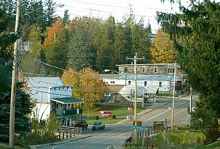
Campbell is the primary hamlet and a census-designated place (CDP) in the town of Campbell in Steuben County, New York, United States. As of the 2010 census, it had a population of 713, out of 3,406 in the entire town of Campbell.
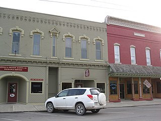
Prattsburgh is the primary hamlet and a census-designated place (CDP) in the town of Prattsburgh in Steuben County, New York, United States. As of the 2010 census, it had a population of 656, out of 2,085 in the entire town of Prattsburgh. The community was incorporated as a village in 1848 but was disincorporated in 1972.

Cumberland-Hesstown is a census-designated place (CDP) located in the northern part of Maurice River Township in Cumberland County, in the U.S. state of New Jersey. Consisting of the unincorporated communities of Cumberland and Hesstown, it is in the eastern part of the county. New Jersey Route 49 passes through the CDP, leading northwest 6 miles (10 km) to Millville and southeast 11 miles (18 km) to Tuckahoe.
Charlottsville is an unincorporated community and census-designated place (CDP) in Blair County, Pennsylvania, United States. It was first listed as a CDP prior to the 2020 census.
Casanova is an unincorporated community and census-designated place (CDP) in Centre County, Pennsylvania, United States. It was first listed as a CDP before the 2020 census.


