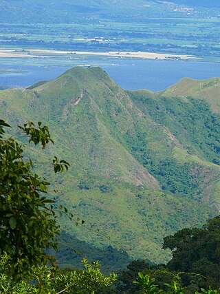
The Cordillera de Merida páramo (NT1004) is an ecoregion containing páramo (high moorland) vegetation above the treeline in the Andes mountain range of Venezuela. The isolated habitat has many endemic species. It is relatively stable and intact.
Páramos in the southwest of the Cordillera de Merida include Batalló at 3,913 metres (12,838ft) above sea level and Nariño at 3,517 metres (11,539ft). The highest point in the central section is the Piedras Blancas peak at 4,729 metres (15,515ft), surrounded by extensive páramos, glaciers and lakes. From the Piedras Blancas páramo the land descends to the Mucuchíes páramo at 4,077 metres (13,376ft), then continues to gradually descend towards the northeast.[3]
Climate
The Köppen climate classification is "ETH": Alpine tundra, with no month with an average temperature in excess of 10 °C (50 °F).[4][5] Where the Northern Andean páramo is generally humid throughout the year with moisture delivered in the form of rain, clouds and fog as air masses are lifted up over the mountains, the Cordillera de Merida páramo is similar to the Costa Rican páramo and Santa Marta páramo, where the trade winds create a distinct dry season.[6] The dominant winds blow northwest from the Amazon region, with a rainy season from around March to November.[7]
Ecology
The Cordillera de Merida páramo ecoregion is in the neotropical realm, in the montane grasslands and shrublands biome.[1] The ecoregion is part of the Northern Andean Paramo global ecoregion, which also includes the Cordillera Central páramo, Santa Marta páramo and Northern Andean páramo terrestrial ecoregions. The plants and animals are adapted to the cold, dry conditions of the high peaks. There is a high level of local endemism, particularly on the more isolated peaks.[8]
Origins
The Andes began to rise in the Miocene epoch, but in the north did not reach their present height until the Pliocene during a period of strong volcanic activity between four and five million years ago. This was the period when land rose above the tree line and the protopáramo vegetation was formed with new species of the Poaceae, Cyperecear, Arteraceae, Ericaceae and other families. During the later parts of the Quaternary epoch a series of short, cold and dry glacial periods alternated with warmer and more humid interglacial periods. The páramo belts moved lower and joined together in the cold periods, and moved higher into unconnected enclaves when the temperatures rose.[9]
The result is a mix of species of tropical and boreal origin with the same genera found in most páramos, but with many endemic species in the individual páramos. The Cordillera de Mérida is the oldest part of the northern Andes, and has a large connected corridor of páramo. The range is probably where most of the páramo flora of tropical origin developed, then migrated south into Colombia during cold glacial periods.[9]
The mountain forest extends up to about 3,000 metres (9,800ft) in altitude, where the páramos begin, Above 4,000 metres (13,000ft) the páramos are replaced by a periglacial zone with very little vegetation, mostly lichens, mosses and some dwarf plants.[10] No flora or fauna are found above around 4,850 metres (15,910ft).[11] The ecoregion mostly consists of dry páramo habitat, with high-altitude tussock grass, stands of dwarf bamboo and open meadows There are also some marshes and bogs, although less than in the wet páramo.[1]
Fauna
Redonda chiquinquirana, a butterfly whose females have limited ability to fly, is endemic to the ecoregion.[12] A study of Carabid beetles found diverse and numerous specimens, all endemic to the ecoregion although closely related to species in other ranges. Carbonellia ater is found between 2,900 and 4,300 metres (9,500 and 14,100ft). The most important Carabid tribes in terms of numbers of species and of individuals belong to the genera Dyscolus and Bembidion.[13] Endangered amphibians include the Mucubaji stubfoot toad (Atelopus mucubajiensis) and Tamá harlequin frog (Atelopus tamaense).[14] Endangered mammals include Musso's fish-eating rat (Neusticomys mussoi).[14]
Viloria, A.L.; Pyrcz, T.W.; Ferrer-Paris, J.R.; Beccaloni, G.; Sattler, K.; Lees, D.C. (2003), "A brachypterous butterfly?", Proceedings of the Royal Society of London B, 270 (S1): S21-4, doi:10.1098/rsbl.2003.0015, PMC1698010, PMID12952626
WildFinder, WWF: World Wildlife Fund, retrieved 2017-04-17
Páramo may refer to a variety of alpine tundra ecosystems located in the Andes Mountain Range, South America. Some ecologists describe the páramo broadly as "all high, tropical, montane vegetation above the continuous timberline". A narrower term classifies the páramo according to its regional placement in the northern Andes of South America and adjacent southern Central America. The páramo is the ecosystem of the regions above the continuous forest line, yet below the permanent snowline. It is a "Neotropical high mountain biome with a vegetation composed mainly of giant rosette plants, shrubs and grasses". According to scientists, páramos may be "evolutionary hot spots", that meaning that it's among the fastest evolving regions on Earth.
Redonda is a butterfly genus from the subfamily Satyrinae in the family Nymphalidae. The genus was erected by Michael Jan Adams and George Igor Bernard in 1981. It is endemic to the Cordillera de Merida páramo in Mérida, Venezuela. There are 10 known species, which are separated in distinct mountain ranges. Most species show some degree of sexual dimorphism in wing size, in the most extreme cases females show some degree of wing deformation which might point to incipient brachyptery.
The Cordillera Oriental is the widest of the three branches of the Colombian Andes. The range extends from south to north dividing from the Colombian Massif in Huila Department to Norte de Santander Department where it splits into the Serranía del Perijá and the Cordillera de Mérida in Venezuelan Andes. The highest peak is Ritacuba Blanco at 5,410 m (17,750 ft) in the Sierra Nevada del Cocuy.
The Cordillera de la Costa montane forests is a montane ecoregion of the tropical and subtropical moist broadleaf forests biome, in the Venezuelan Coastal Range on the Caribbean Sea in northern Venezuela.
The Tamá National Natural Park is a national park located in the Tamá Massif of the Andean Region of Colombia, between the municipalities Toledo and Herrán, in the department of Norte de Santander, in the northeastern part of the Eastern Ranges of the Colombian Andes. One of the main attractions of the park is a 820-metre-high (2,690 ft) waterfall, one of the world's highest.
The Marañón dry forests (NT0223) is an ecoregion in northern Peru. It covers the lower valley of the Marañón River and its tributaries along the eastern edge of the Andes. It has a dry climate due to rain shadow from mountains further east. The habitat has long been modified by farming, ranching and logging and is now threatened by construction of hydroelectric and irrigation dams.
The Magdalena Valley dry forests (NT0221) is an ecoregion in Colombia along the upper Magdalena River, a large river that runs from south to north between the two main cordilleras of the Andes. There are many endemic species, but much of the original habitat has been destroyed by agriculture and over-grazing, mainly by goats. The habitat is not protected by any national park, and is at risk of complete destruction.
The Northern Andean páramo (NT1006) is an ecoregion containing páramo vegetation above the treeline in the Andes of Colombia and Ecuador. In the past, when the climate was cooler, the treeline and the páramo units were lower and the units were connected. During the present warmer Holocene epoch the páramos have migrated uphill, shrinking and becoming isolated. They contain many rare or endangered species, some of them restricted to a narrow area of one mountain or mountain range. The ecoregion is relatively well preserved, but faces threats from over-grazing and farming.
The Santa Marta páramo (NT1007) is an ecoregion containing páramo vegetation above the treeline in the Sierra Nevada de Santa Marta mountain range on the Caribbean coast of Colombia. The isolated position of the range has allowed unique species to evolve. Some are related to those found in Central America and the Caribbean coastal areas, and some to species from the Andes. The habitat is relatively stable, but has been drastically changed from the original by long-term human activity.
The Cordillera Central páramo (NT1004) is an ecoregion containing páramo vegetation above the treeline in the Andes mountain range of northern Peru and southern Ecuador. Due to its isolation there are high levels of endemism. Despite many human settlements and some destruction of habitat by agriculture and mining, the ecoregion is relatively intact.
The Venezuelan Andes montane forests (NT0175) is an ecoregion in the northern arm of the Andes in Venezuela. It contains montane and cloud forests, reaching up to the high-level Cordillera de Merida páramo high moor ecoregion. The forests are home to many endemic species of flora and fauna. Their lower levels are threatened by migrant farmers, who clear patches of forest to grow crops, then move on.
The Tamá Massif is a group of mountains on the border between Colombia and Venezuela to the south of Lake Maracaibo. It contains evergreen rainforest and cloud forest at the lower levels, and páramos at the highest levels.
The Cordillera Oriental montane forests (NT0118) is an ecoregion in Venezuela and Colombia along the east slopes of the eastern cordillera of the Andes. The extensive region of submontane and montane forests includes distinctive flora and fauna in the north, center and southern sections. The ecoregion is home to numerous endemic species of fauna. Despite extensive changes due to logging, farming and ranching, large areas of the original habitat remain intact, and the ecoregion has rich biodiversity.
The Catatumbo moist forests (NT0108) is an ecoregion in Venezuela and Colombia to the west and east of Lake Maracaibo. It includes four regions of moist forest on slightly higher ground than the dry forest and mangroves that surround the lake. The forest has unique flora related to the flora of the Amazon basin. It is badly degraded due to farming, livestock grazing and oil exploration.
The Táchira Depression is a saddle of land connecting the Lake Maracaibo basin to the Orinoco basin in the state of Táchira, Venezuela. It forms a break in the eastern Andes, separating the Tamá Massif to the west from the Cordillera de Mérida to the east. The depression has been thought to present a barrier to the movement of species between the Colombian and Venezuelan Andes, but this effect may have been relatively low during the recent ice ages. The mountains of the region have potential for coffee farming and hydroelectric power generation, while the lower levels are suitable for farming.
The Northwestern Andean montane forests (NT0145) is an ecoregion on the Andes mountains in the west of Colombia and Ecuador. Both flora and fauna are highly diverse due to effect of ice ages when the warmer climate zones were separated and the cooler ones combined, and interglacial periods when the reverse occurred. Because the environment is hospitable to humans, the habitat has been drastically modified by farming and grazing since the Pre-Columbian era.
The Magdalena Valley montane forests (NT0136) is an ecoregion in the Andes mountains of central Colombia.
The Cauca Valley montane forests (NT0109) is an ecoregion in western Colombia. It covers the sides of the Cauca Valley, which runs from south to north between the Central and Western Ranges (cordilleras) of the Colombian Andes. The ecoregion is home to very diverse fauna and flora, due in part to its varied elevations and climates, in part to its position near the isthmus of Panama, the route along which North American species invaded South America and then diversified as they moved to the upper parts of the Andes. Little of the original habitat remains at lower levels, but higher up there are sizeable blocks of forest, some of which are protected.
The Santa Marta montane forests (NT0159) is an ecoregion in the Sierra Nevada de Santa Marta, a massif on the Caribbean coast of northern Colombia. The ecoregion covers altitudes from near sea level up to around 3,300 metres (10,827 ft), where it gives way to Santa Marta páramo. The isolation of the massif and the range of elevations and climates has resulted in a wide variety of species including many endemics. The lower levels contained tropical rainforest, which has largely been cleared. Higher up, this gives way to cloud forest. Much of this has also been cleared for coffee plantations, pasture for sheep and cattle, and farming.
The Eastern Cordillera Real montane forests (NT0121) is an ecoregion in the eastern range of the Andes of southern Colombia, Ecuador and northern Peru. The ecoregion covers the eastern slopes of the Andes, and includes montane forest that rises from the Amazonian rain forest, with cloud forest and elfin forest at higher elevations. It is rich in species, including many endemics. It is threatened by logging and conversion for pasturage and subsistence agriculture.
This page is based on this Wikipedia article Text is available under the CC BY-SA 4.0 license; additional terms may apply. Images, videos and audio are available under their respective licenses.