Chiloé Island also known as Greater Island of Chiloé, is the largest island of the Chiloé Archipelago off the west coast of Chile, in the Pacific Ocean. The island is located in southern Chile, in the Los Lagos Region.

The Valdivian temperate forests (NT0404) is an ecoregion on the west coast of southern South America, in Chile and Argentina. It is part of the Neotropical realm. The forests are named after the city of Valdivia. The Valdivian temperate rainforests are characterized by their dense understories of bamboos, ferns, and for being mostly dominated by evergreen angiosperm trees with some deciduous specimens, though conifer trees are also common.

Fitzroya is a monotypic genus in the cypress family. The single living species, Fitzroya cupressoides, is a tall, long-lived conifer native to the Andes mountains and coastal regions of southern Chile, and only to the Argentine Andes, where it is an important member of the Valdivian temperate forests. Common names include alerce, lahuán, and Patagonian cypress. The genus was named in honour of Robert FitzRoy.

Darwin's fox or Darwin's zorro is an endangered canid from the genus Lycalopex. It is also known as the zorro chilote or zorro de Darwin in Spanish and lives on Nahuelbuta National Park, the Cordillera de Oncol, Cordillera Pelada in mainland Chile and Chiloé Island. This small, dark canine weighs 1.8 to 3.95 kg, has a head-and-body length of 48 to 59 cm and a tail that is 17.5 to 25.5 cm. Darwin's fox displays no key differences between male and female other than the fact that the male has a broader muzzle. Males display no territorial behavior and aren't aggressive towards other males roaming around their territory.

The Los Ríos Region is one of Chile's 16 regions, the country's first-order administrative divisions. Its capital is Valdivia. It began to operate as a region on October 2, 2007, having been created by subdividing the Los Lagos Region in southern Chile. It consists of two provinces: Valdivia and the newly created Ranco Province, which was formerly part of Valdivia Province.

Valdivia is a city and commune in southern Chile, administered by the Municipality of Valdivia. The city is named after its founder, Pedro de Valdivia, and is located at the confluence of the Calle-Calle, Valdivia, and Cau-Cau Rivers, approximately 15 km (9 mi) east of the coastal towns of Corral and Niebla. Since October 2007, Valdivia has been the capital of Los Ríos Region and is also the capital of Valdivia Province. The national census of 2017 recorded the commune of Valdivia as having 166,080 inhabitants (Valdivianos), of whom 150,048 were living in the city. The main economic activities of Valdivia include tourism, wood pulp manufacturing, forestry, metallurgy, and beer production. The city is also the home of the Austral University of Chile, founded in 1954 and the Centro de Estudios Científicos.

Los Ruiles National Reserve is a small nature reserve located in Cauquenes Province of Maule Region in central Chile. The reserve consists of two sections that protect enclaves of native forest, which are home to several threatened and endangered species.

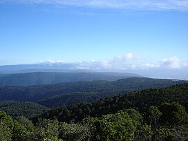
The Chilean Coastal Range is a mountain range that runs from north to south along the Pacific coast of South America parallel to the Andean Mountains, extending from Morro de Arica in the north to Taitao Peninsula, where it ends at the Chile Triple Junction, in the south. The range has a strong influence on the climate of Chile since it produces a rain shadow to the east. Because of this the vegetation growing on the seaward slopes is much more exuberant than in the interior. Compared to the coastal lowlands and the Intermediate Depression, it is sparsely populated with land use varying from protected areas to grazing and silviculture. The range is present in all Chilean regions, except for Coquimbo Region and Magallanes Region.

Zona Sur is one of the five natural regions on which CORFO divided continental Chile in 1950. Its northern border is formed by the Bío-Bío River, which separates it from the Central Chile Zone. The Southern Zone borders the Pacific Ocean to the west, and to the east lies the Andean mountains and Argentina. Its southern border is the Chacao Channel, which forms the boundary with the Austral Zone. While the Chiloé Archipelago belongs geographically to the Austral Zone in terms of culture and history, it lies closer to the Southern Zone.

Valdivian Coastal Reserve is a natural reserve located in the Cordillera Pelada, in Los Ríos Region of Chile, near Corral.
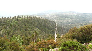
Oncol Park is a natural reserve located 32 km (20 mi) from the city of Valdivia, Chile. The park has an area of 7.54 km2 (3 sq mi) of which most lies on Cerro Oncol, the highest peak of the Valdivian Coast Range, but is only 5 km (3 mi) from the coast. Oncol Park is located in an area of 15 km2 (6 sq mi) of continuous Valdivian temperate rain forest. From the peak of Cerro Oncol it is possible to see Llaima Volcano, Villarrica Volcano and even Mount Tronador on the international border of Chile and Argentina. The park is property of the wood pulp enterprise Celulosa Arauco y Constitución.
Alerce Costero National Park is a protected wild area in the Cordillera Pelada about 137 km from Valdivia and 49 km from La Unión. Fitzroya trees grow inside the protected area and give the area its name, with Alerce Costero translating as Coastal Fitzroya. The Natural Monument has a total area of 137 hectares.

Cerro Oncol is a mountain located in the Cordillera de Oncol, Chile. With its 715 m it is the highest peak of the Chilean Coast Range between Nahuelbuta Range and Corral Bay. Cerro Oncol and its surroundings are located inside Oncol Park.

The native flora of Chile is characterized by a higher degree of endemism and relatively fewer species compared to the flora of other countries of South America. A classification of this flora necessitates its division into at least three general zones: the desert provinces of the north, Central Chile, and the humid regions of the south.
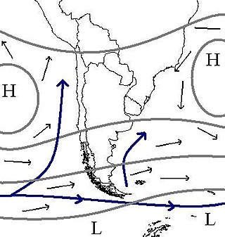
The climate of Chile comprises a wide range of weather conditions across a large geographic scale, extending across 38 degrees in latitude, making generalizations difficult. According to the Köppen system, Chile within its borders hosts at least seven major climatic subtypes, ranging from low desert in the north, to alpine tundra and glaciers in the east and southeast, tropical rainforest in Easter Island, Oceanic in the south and Mediterranean climate in central Chile. There are four seasons in most of the country: summer, autumn, winter, and spring.

The Pirulil Range is a mountain range located in the southern half of Chiloé Island. It is located along the Pacific coast and forms part of the larger Chilean Coast Range. It northern boundary is the Cucao Lake, beyond of which Cordillera del Piuchén rises. To the south the range ends at Corcovado Gulf.
Lancahue is a protected area and watershed in the commune of Valdivia, Chile. It has an area of 12.7 km2, of which 7 km2 are old-growth forest. The protected area host a relatively unscathed remnant of lowland Valdivian temperate forest. Part of the protected area contain secondary forest that started to develop after a fire around 1914, while other secondary forests originated from intense wood logging.
Área Costera Protegida Punta Curiñanco is a natural reserve 40 km (25 mi) from the city of Valdivia, Chile. The park has an area of 80 ha on the headland of Punta Curiñanco at just at the northern end of Curiñanco beach and village and on the western side of the Valdivian Coast Range. Punta Curiñanco covers area that includes different types of Valdivian temperate rain forest as well as coastal shrublands, wetlands and sea-side rocks.
In Colonial times the Spanish Empire diverted significant resources to fortify the Chilean coast as a consequence of Dutch and English raids. During the 16th century the Spanish strategy was to complement the fortification work in its Caribbean ports with forts in the Strait of Magellan. As attempts at settling and fortifying the Strait of Magellan were abandoned the Spanish began to fortify the Captaincy General of Chile and other parts of the west coast of the Americas. The coastal fortifications and defense system was at its peak in the mid-18th century.