Related Research Articles

Benton County is a county in the Northwest region of the U.S. state of Arkansas. Created as Arkansas' 35th county on September 30, 1836, Benton County contains thirteen incorporated municipalities, including Bentonville, the county seat, and Rogers, the most populous city. The county was named after Thomas Hart Benton, a U.S. Senator from Missouri influential in Arkansas statehood.

The Ozarks, also known as the Ozark Mountains, Ozark Highlands or Ozark Plateau, is a physiographic region in the U.S. states of Missouri, Arkansas, Oklahoma and the extreme southeastern corner of Kansas. The Ozarks cover a significant portion of northern Arkansas and most of the southern half of Missouri, extending from Interstate 40 in central Arkansas to Interstate 70 in central Missouri.

The White River is a 722-mile (1,162 km) river that flows through the U.S. states of Arkansas and Missouri. Originating in the Boston Mountains of northwest Arkansas, it arcs northwards through southern Missouri before turning back into Arkansas, flowing southeast to its mouth at the Mississippi River.
The Ozark – St. Francis National Forest is a United States National Forest that is located in the state of Arkansas. It is composed of two separate forests, Ozark National Forest in the Ozark Mountains; and St. Francis National Forest on Crowley's Ridge. Each forest has distinct biological, topographical, and geological differences.

The Severn River is a tidal estuary 14 miles (23 km) long, located in Anne Arundel County in the U.S. state of Maryland, south of the Magothy River and north of the South River.

The geography of Arkansas varies widely. The state is covered by mountains, river valleys, forests, lakes, and bayous in addition to the cities of Arkansas. Hot Springs National Park features bubbling springs of hot water, formerly sought across the country for their healing properties. Crowley's Ridge is a geological anomaly rising above the surrounding lowlands of the Mississippi embayment.

Highway 14 is an east–west state highway in Arkansas. The route of 227.35 miles (365.88 km) begins at Boat Dock Road near Table Rock Lake and runs east to Mississippi County Route W1020 (CR W1020) at Golden Lake. Segments of the highway are part of two Arkansas Scenic Byways: Sylamore Scenic Byway in the Ozark National Forest and the Crowley's Ridge Parkway atop Crowley's Ridge.
Bear Creek Springs is an unincorporated community in Boone County, Arkansas, United States. It is the location of Bear Creek Motel, which is located on U.S. 65 and is listed on the National Register of Historic Places.

New Blaine is an unincorporated community and census-designated place (CDP) in Logan County, Arkansas, United States. Per the 2020 census, the population was 173.

The Cove Creek Bridge is a historic bridge, carrying Arkansas Highway 309 across Cove Creek, south of the hamlet of Corley, Arkansas in the Ozark-St. Francis National Forest. It is a two-span closed-spandrel masonry arch structure, with each span measuring 13 feet (4.0 m) and an overall structure length of 26 feet (7.9 m). It is built entirely out of stone, with a concrete and asphalt deck, and concrete barriers at the sides. It was built in 1936 with funding support from the Works Progress Administration.

Arkansas Highway 309 is a designation for two state highways in Western Arkansas. One route of 5.11 miles (8.22 km) runs from Yell County Route 28 (CR 28) at Blue Mountain Lake northeast to Highway 10 at Waveland. A second segment begins at Highway 10 in Havana and winds northwest through the Ozark National Forest to Highway 23 at Webb City via Paris. A portion of the second route is designated as the Mount Magazine Scenic Byway, one of eleven Arkansas Scenic Byways maintained by the Arkansas State Highway and Transportation Department (AHTD).
Big Piney Creek is a river located in Ozark National Forest in the state of Arkansas. It is a tributary of the Arkansas River and therefore part of the Mississippi River watershed. Managed by the United States Forest Service, it flows for 70.8 miles (113.9 km) through Pope, Johnson and Newton counties. The headwaters of the creek are in a rugged, remote area just east of Arkansas Route 21 south of the community of Fallsville and the mouth of the creek empties into Lake Dardanelle on the Arkansas River.
The Spring Lake Bridge is a historic bridge in the eastern part of Ozark-St. Francis National Forest, carrying County Road 35 across an inlet of Spring Lake known as Bob Barnes Branch, in the Spring Lake Recreation Area with the Ozark–St. Francis National Forest. It is a two-span closed-spandrel stone arch bridge with a total length of 36 feet (11 m). Each arch is 10 feet (3.0 m) long and 6 feet (1.8 m) high. Built in 1936 with federal funding, it is one of the state's finest examples of a stone arch bridge.

Spring Lake Recreation Area is located in the Magazine Ranger District of the Ozark-St. Francis National Forest in Yell County north of Danville, Arkansas. Constructed in 1937 with Works Progress Administration (WPA) funds, Spring Lake's rustic native stone and log Civilian Conservation Corp style structures include two picnic pavilions and developed picnic sites, a bathhouse, two swimming platforms, the Spring Lake Bridge, walkways, stone walls, and the lake's dam, which impounds Spring Creek at the lake's southern end. The recreation area also includes 13 campsites. The area was listed on the National Register of Historic Places in 1995 as the Spring Lake Recreation Area Historic District.

The Big Piney Creek Bridge is a historic bridge, carrying Arkansas Highway 123 across Big Piney Creek in Ozark-St. Francis National Forest, northeast of Hagarville, Arkansas. Its main span is a Warren through truss structure, 141 feet (43 m) in length, with steel deck girder approach spans giving the bridge a total length of 461 feet (141 m). The trusses are mounted on concrete piers. The bridge was built in 1931, during a period of financial hardship, and was for economic reasons built with a single-lane 12-foot (3.7 m) roadway.

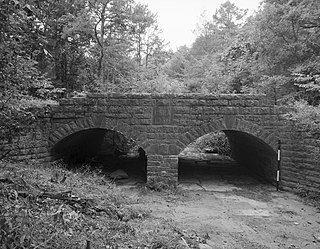
The Cove Creek Tributary Bridge is a historic bridge in rural Logan County, Arkansas. It is a two-span closed-spandrel stone arch bridge, carrying Arkansas Highway 309 across a tributary of Cove Creek north of Corley in Ozark-St. Francis National Forest. Each of its arches is 11 feet (3.4 m) long, and the structure is an overall 23 feet (7.0 m) in length. Concrete barriers form the sides of the bridge on either side of the roadway. The bridge was built in 1936 under the auspices of the Arkansas Highway Commission.

The Cove Lake Spillway Dam and Bridge are historic structures in Ozark-St. Francis National Forest, north of Corley, Arkansas. The dam is built of earth and stone, and impounds Cove Lake, location of a recreation area in the national forest. The bridge is a five-span masonry arch structure, built across the dam spillway, where it carries Arkansas Highway 309. The dam and bridge were built in 1937 with funding from the Works Progress Administration, and is a fine example of the Rustic architecture WPA projects were known for.
The White Rock Wildlife Management Area (WMA) was designated in 1976 as 280,000 acres (110,000 ha) of protected area within the boundaries of the Ozark National Forest. The WMA is owned by the U. S. Forest Service and managed under the provisions of a Memorandum of Understanding by the Arkansas Game and Fish Commission, and is situated in the Boston Mountains of Northwest Arkansas.
Hurricane Creek is a tributary to the Big Piney Creek, a river in Ozark-St. Francis National Forest in the state of Arkansas, which is a tributary of the Arkansas River and which is, in turn, part of the Mississippi River System. It is managed by the United States Forest Service and categorized as one of the Wild and Scenic Rivers of the United States.
North Sylamore Creek is a tributary of South Sylamore Creek in Stone County, Arkansas in the United States.
References
Municipalities and communities of Logan County, Arkansas, United States | ||
|---|---|---|
| Cities |  | |
| Towns | ||
| CDP | ||
| Unincorporated communities | ||
35°12′48″N93°38′05″W / 35.21333°N 93.63472°W
| | This article about a location in Logan County, Arkansas is a stub. You can help Wikipedia by expanding it. |