
Greater Los Angeles is the most populous metropolitan area in the U.S. state of California, encompassing five counties in Southern California extending from Ventura County in the west to San Bernardino County and Riverside County in the east, with the city of Los Angeles and Los Angeles County at its center, and Orange County to the southeast. The Los Angeles–Anaheim–Riverside combined statistical area (CSA) covers 33,954 square miles (87,940 km2), making it the largest metropolitan region in the United States by land area. The contiguous urban area is 2,281 square miles (5,910 km2), whereas the remainder mostly consists of mountain and desert areas. With an estimated population of over 18.3 million, it is the second-largest metropolitan area in the country, behind New York, as well as one of the largest megacities in the world.
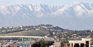
Corona is a city in northwestern Riverside County, California, United States. At the 2020 census, the city had a population of 157,136, up from 152,374 at the 2010 census. Corona is surrounded by Riverside to the east, Norco to the north and northeast, Yorba Linda to the northwest, Cleveland National Forest and the Santa Ana Mountains to the west, southwest, and south. Several unincorporated communities are along the rest of the city's borders. Downtown Corona is approximately 48 miles southeast of Downtown Los Angeles and 95 miles (153 km) north-northwest of San Diego.

Lake Elsinore is a city in western Riverside County, California, United States. Established as a city in 1888, it is on the shore of Lake Elsinore, a natural freshwater lake about 3,000 acres (1,200 ha) in size. The city has grown from a small resort town in the late 19th and early 20th centuries to a suburban city with over 70,000 residents.

The Santa Ana River is the largest river entirely within Southern California in the United States. It rises in the San Bernardino Mountains and flows for most of its length through San Bernardino and Riverside counties, before cutting through the northern Santa Ana Mountains via Santa Ana Canyon and flowing southwest through urban Orange County to drain into the Pacific Ocean. The Santa Ana River is 96 miles (154 km) long, and its drainage basin is 2,650 square miles (6,900 km2) in size.
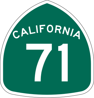
State Route 71 (SR 71) is a 15-mile (24 km) state highway in the U.S. state of California. Serving Riverside, San Bernardino, and Los Angeles counties, it runs from SR 91 in Corona to the Kellogg Interchange with I-10 and SR 57 on the border of Pomona and San Dimas. The segment from SR 91 to SR 83 in Chino Hills is called the Corona Freeway, formerly the Corona Expressway and before then the Temescal Freeway. SR 71 is designated as the Chino Valley Freeway between SR 83 and the Kellogg Interchange.
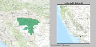
California's 41st congressional district is a congressional district in Riverside County, in the U.S. state of California. The district is currently represented by Republican Ken Calvert.
Rancho Jurupa was a 40,569-acre (164.18 km2) Mexican land grant in California, United States, that is divided by the present-day counties of Riverside and San Bernardino. The land was granted to Juan Bandini by Governor Juan B. Alvarado in 1838. Located along both banks of the Santa Ana River in southern California, the rancho included much of the land in the present day city of Jurupa Valley, as well as the downtown area in the city of Riverside.
The Corona-Norco Unified School District (CNUSD) is a school district in Riverside County, California, in the United States, serving the cities of Corona, Norco, and Eastvale, along with the CDPs of Coronita, El Cerrito, Home Gardens, Lake Mathews and Temescal Valley, and a small portion of Jurupa Valley. It is the largest public school district in Riverside County and was named the California Exemplary School District of 2019. CNUSD has 50 schools in operation: 30 elementary schools, 3 K–8 academies, 8 intermediate schools, 1 Hybrid school, and 8 high schools. The school board is composed of five members, elected by geographical district and serve a four-year term with the elections being held in November of even-numbered years.

Rancho La Sierra was a 17,769-acre (71.91 km2) Mexican land grant in present-day Riverside County, California, United States. In 1846 governor Pio Pico issued the grant to Bernardo Yorba. The grant lay between Rancho Jurupa and Rancho El Rincon, and included the present-day city of Corona.
Rancho La Sierra was a 17,774-acre (71.93 km2) Mexican land grant in present-day Riverside County, California, United States. In 1846 Governor Pio Pico issued the grant to Vicenta Sepulveda. The rancho includes the present-day city of Norco, and the western end of Riverside.
Rancho La Laguna was a 13,339-acre (53.98 km2) Mexican land grant in present-day Riverside County, California given in 1844 by Governor Manuel Micheltorena to Julian Manriquez. The rancho lands are included in the present day city of Lake Elsinore and Wildomar. At the time of the US Patent, Rancho Laguna was a part of San Diego County. The County of Riverside was created by the California Legislature in 1893 by taking land from both San Bernardino and San Diego Counties.
Riverside, California, was founded in 1870, and named for its location beside the Santa Ana River. It became the county seat when Riverside County, California, was established in 1893.

Temescal Creek is an approximately 29-mile-long (47 km) watercourse in Riverside County, in the U.S. state of California. Flowing primarily in a northwestern direction, it connects Lake Elsinore with the Santa Ana River. It drains the eastern slopes of the Santa Ana Mountains on its left and on its right the western slopes of the Temescal Mountains along its length. With a drainage basin of about 1,000 square miles (2,600 km2), it is the largest tributary of the Santa Ana River, hydrologically connecting the 720-square-mile (1,900 km2) San Jacinto River and Lake Elsinore watersheds to the rest of the Santa Ana watershed. However, flowing through an arid rain shadow zone of the Santa Ana Mountains, and with diversion of ground water for human use, the creek today is ephemeral for most of its length, except for runoff from housing developments and agricultural return flows.

Riverside County is a county located in the southern portion of the U.S. state of California. As of the 2020 census, the population was 2,418,185, making it the fourth-most populous county in California and the 10th-most populous in the United States. The name was derived from the city of Riverside, which is the county seat.

Rancho Temescal was a farming outpost of Mission San Luis Rey de Francia, one of the 21 Franciscan missions established in California by Spain during the late 18th and early 19th centuries. The Mission was located on the coast where Oceanside, California, is today. The Rancho was settled in 1819 by Leandro Serrano, and became the first non-native settlement within the boundaries of what would become Riverside County, California.

Temescal Valley is a census-designated place in Riverside County, California. Temescal Valley sits at an elevation of 1,138 feet (347 m). The 2010 United States census reported Temescal Valley's population was 22,535.
Lee Lake, is a reservoir created by the Lee Lake 818-002 Dam across Temescal Creek, in Riverside County, California. It lies at an elevation of 1,122 feet (342 m).

The Temescal Butterfield stage station is the site where the Butterfield Overland Mail stagecoach stopped to deliver mail and get fresh horses in what is now Riverside County, California. The Temescal Butterfield stage station was designated a California Historic Landmark (No.188) on June 20, 1935. The site of the Temescal Butterfield stage station is currently near the City of Corona along Temescal Canyon Road. The first stagecoach with mail and passengers departed Tipton, Missouri on September 15, 1858. The stagecoach stopped at the Temescal Butterfield stage station and arrived at the Butterfield Overland Mail Company Los Angeles Building on October 7, 1858. The Butterfield Overland Mail Company closed in 1861.
The title of Lemon Capital of the World has been give to these places, for growing large amounts of lemons:
Arthur Samuel Garretson was an American banker, businessman, and politician in Sioux City, Iowa. Garretson had a part in several major aspects of Sioux City's growth. Garretson, South Dakota, was named after him.


