Council, North Carolina | |
|---|---|
 Council | |
| Coordinates: 34°25′16″N78°28′03″W / 34.42111°N 78.46750°W | |
| Country | |
| State | North Carolina |
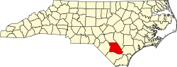
| County | Bladen |
| Elevation | 21 m (69 ft) |
| Time zone | UTC-5 (Eastern (EST)) |
| • Summer (DST) | UTC-4 (EDT) |
| ZIP code | 28434 |
| Area codes | 910, 472 |
| GNIS feature ID | 983601 [1] |
Council is an unincorporated community in Bladen County, North Carolina, United States.