
The County of Canning is a county in Queensland, Australia. The county consists of almost all of the former Shires of Caboolture, Maroochy and Kilcoy and the former City of Caloundra. Its main urbanised areas are centred on the Sunshine Coast and the areas surrounding Caboolture.

For lands administrative purposes, New South Wales is divided into 141 counties, which are further divided into parishes. The counties were first set down in the Colony of New South Wales, which later became the Australian state of New South Wales.

Lands administrative divisions of Australia are the cadastral divisions of Australia for the purposes of identification of land to ensure security of land ownership. Most states term these divisions as counties, parishes, hundreds, and other terms. The eastern states of Queensland, New South Wales, Victoria, and Tasmania were divided into counties and parishes in the 19th century, although the Tasmanian counties were renamed land districts in the 20th century. Parts of South Australia (south-east) and Western Australia (south-west) were similarly divided into counties, and there were also five counties in a small part of the Northern Territory. However South Australia has subdivisions of hundreds instead of parishes, along with the Northern Territory, which was part of South Australia when the hundreds were proclaimed. There were also formerly hundreds in Tasmania. There have been at least 600 counties, 544 hundreds and at least 15,692 parishes in Australia, but there are none of these units for most of the sparsely inhabited central and western parts of the country.

Lands administrative divisions of Queensland refers to the divisions of Queensland used for the registration of land titles. There are 322 counties, and 5,319 parishes within the state. They are part of the Lands administrative divisions of Australia. Queensland had been divided into 109 counties in the nineteenth century, before the Land Act of 1897 subdivided many of these counties to 319. Some of the eastern counties remained the same, with most of the subdivisions occurring in the west and north. The current counties were named and bounded by the Governor in Council on 7 March 1901.

The County of Elphinstone is a cadastral division of Queensland which contains the city of Townsville. It was named after George Elphinstone Dalrymple (1826–1876), a politician and explorer. The county is divided into civil parishes. Townsville is mentioned as being in the county of Elphinstone in the 1911 Britannica. It is bounded by the Haughton River in the east, and part of the Burdekin River in the south-west.

The county of Nares is a cadastral division of Queensland which contains the city of Cairns, Innisfail and most of the Atherton Tableland. The county is divided into civil parishes. It was named after George Nares (1831–1915), a naval officer and commander of HMS Salamander. Cairns is mentioned as being in the county of Nares in the 1911 Britannica. It is bounded by the Daintree River in the north.

The County of March is a county in Queensland, Australia. The county consists of the Noosa area, plus the eastern parts of the Gympie and Fraser Coast regions.

The County of Belmore is a county in Queensland, Australia, located west of the Darling Downs in the Shire of Balonne.

The county of Solander is a cadastral division of Queensland which contains the towns of Ayton, Daintree, Mossman and Port Douglas. The county is divided into civil parishes.
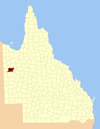
The County of Rochedale is a county in Queensland, Australia. The county is divided into civil parishes. It is centred on the city of Mount Isa, its only population centre. On 7 March 1901, the Governor issued a proclamation legally dividing Queensland into counties under the Land Act 1897. Its schedule described Rochedale thus:
Bounded on the north by the county of Brahe and parts of the west and south of Glenvale No. 2 Block to the Leichhardt River, by that river upwards to the north-west corner of Parkside No. 1, by the north, east and south boundaries of that block, part of the south and east boundaries of Parkside No. 2, part of the north, the east, and south boundaries of Parkside No. 5, and the east boundary of Parkside No. 8 Block; on the south by the counties of Chapworth, Waverley and Piturie; and on the west by the county of Nash.

The County of Ferguson is a county in Queensland, Australia, located in the Shire of Banana in Central Queensland. The county is divided into civil parishes. The county was officially named and bounded by the Governor in Council on 7 March 1901 under the Land Act 1897.
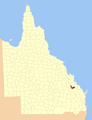
The County of Pelham is a county in Queensland, Australia, located in the Shire of Banana in Central Queensland. The county is divided into civil parishes. The county was created on 1 September 1855 by royal proclamation under the Waste Lands Australia Act 1846. On 7 March 1901, the Governor issued a proclamation legally dividing Queensland into counties under the Land Act 1897. Its schedule described Pelham thus:
Bounded on the north by the county of Raglan; on the east by the counties of Clinton and Rawbelle; on the south by the county of Rawbelle and the southern watershed of Scoria and Prospect Creeks; and on the west by the eastern watershed of the Dawson River.

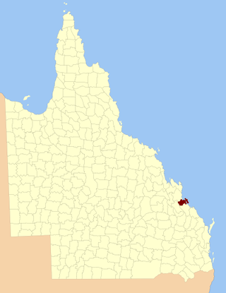
The County of Flinders is a county in Queensland, Australia, located in the Central Queensland region between Gladstone and Bundaberg. The county is divided into civil parishes. It was named for Matthew Flinders who explored the Australian coastline.
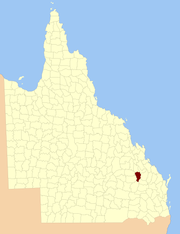
The County of Deas Thompson is a county in Queensland, Australia. It is situated between the cities of Gladstone and Rockhampton. The county is divided into civil parishes. The county was named for Edward Deas Thomson, a New South Wales politician, but the name was misspelt Thompson when applied to the county.
Toko County is one of the 318 Counties of Queensland Australia it is within the North Gregory District of western Queensland. The county is divided into civil parishes. The county is on the Queensland - Northern Territory Border.
Titheroo County, Queensland is one of the 318 counties of Queensland, Australia. The county is divided into civil parishes. It is within the South Gregory Land District.
Weymouth County, Queensland is one of the 318 Counties of Queensland Australia. The County is centered on Weymouth Bay, Cape York Peninsula within the Cook Land District. The county is divided into civil parishes.

The County of Rosebery is a county in Queensland, Australia. It is centred in the South Gregory Lands District. Like all counties in Queensland, it is a non-functional administrative unit, that is used mainly for the purpose of registering land titles.

Wellington County, Queensland is a cadastral division of Queensland and a County of remote western Queensland.

Kendall County is a County of Queensland located at 13.683°S 141.967°E on the Cape York Peninsula in remote far north of Queensland, Australia.