
The Barnard Island Group is a protected area in the Cassowary Coast Region, Queensland, Australia.
Earl Fortescue is a title in the Peerage of Great Britain that was created in 1789 for Hugh Fortescue, 3rd Baron Fortescue (1753–1841), a Member of Parliament for Beaumaris and Lord-Lieutenant of Devon.

North Queensland or the Northern Region is the northern part of the Australian state of Queensland that lies just south of Far North Queensland. Queensland is a massive state, larger than many countries, and the tropical northern part of it has been historically remote and undeveloped, resulting in a distinctive regional character and identity.

Fortescue is an community in Downe Township, Cumberland County, New Jersey, United States. The community is located on the state's southern coast, on Delaware Bay, surrounded on three sides by marshland. It has a population of about 400. The area was named for John Fortescue, a local property owner at the time of American independence.

East Allington is a village and civil parish in the South Hams district of Devon, England, three miles south of Halwell and just off the A381 road. It lies about three miles from Kingsbridge and about ten miles from Totnes. The coast at Slapton Sands is about five miles to the south-east. Also in the parish is the hamlet of The Mounts, about a mile away.

Lands administrative divisions of Australia are the cadastral divisions of Australia for the purposes of identification of land to ensure security of land ownership. Most states term these divisions as counties, parishes, hundreds, and other terms. The eastern states of Queensland, New South Wales, Victoria and Tasmania were divided into counties and parishes in the 19th century, although the Tasmanian counties were renamed land districts in the 20th century. Parts of South Australia (south-east) and Western Australia (south-west) were similarly divided into counties, and there were also five counties in a small part of the Northern Territory. However South Australia has subdivisions of hundreds instead of parishes, along with the Northern Territory, which was part of South Australia when the hundreds were proclaimed. There were also formerly hundreds in Tasmania. There have been at least 600 counties, 544 hundreds and at least 15,692 parishes in Australia, but there are none of these units for most of the sparsely inhabited central and western parts of the country.
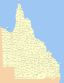
Lands administrative divisions of Queensland refers to the divisions of Queensland used for the registration of land titles. There are 322 counties, and 5,319 parishes within the state. They are part of the Lands administrative divisions of Australia. Queensland had been divided into 109 counties in the nineteenth century, before the Land Act of 1897 subdivided many of these counties to 319. Some of the eastern counties remained the same, with most of the subdivisions occurring in the west and north. The current counties were named and bounded by the Governor in Council on 7 March 1901.

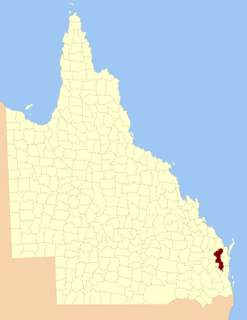
The county of Nares is a cadastral division of Queensland which contains the city of Cairns, Innisfail and most of the Atherton Tableland. It was named after George Nares (1831–1915), a naval officer and commander of HMS Salamander. Cairns is mentioned as being in the county of Nares in the 1911 Britannica. It is bounded by the Daintree River in the north.

Leyburn is a town in the Southern Downs Region and a locality split between the South Downs Region and the Toowoomba Region in Queensland, Australia.
Wyreema is a town and a locality in the Toowoomba Region, Queensland, Australia. At the 2016 census, Wyreema had a population of 1,834.

Tingoora is a rural town and a locality in the South Burnett Region, Queensland, Australia. In the 2016 census, Tingoora had a population of 273 people.
The County of Bentinck is a county located on the southern boundary of the state of Queensland, Australia. Like all counties in Queensland, it is a non-functional administrative unit, that is used mainly for the purpose of registering land titles. The county was named in 1838 after William Cavendish-Bentinck, 3rd Duke of Portland, who served as Prime Minister of Great Britain twice, in 1783 and again between 1807 and 1809. Population centres within the County of Bentinck include the towns of Stanthorpe, Wallangarra, Glen Aplin, Applethorpe and Inglewood.
The County of Cavendish is a county in Queensland, Australia. Like all counties in Queensland, it is a non-functional administrative unit, that is used mainly for the purpose of registering land titles. The county includes the northern part of the Toowoomba Region and the western part of the Somerset Region. The county was officially named and bounded by the Governor in Council on 7 March 1901 under the Land Act 1897.
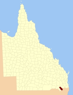
The county of Cook is a cadastral division of Queensland, centred on the city of Bundaberg, and its name honours Captain James Cook. It was officially named and bounded by the Governor in Council on 7 March 1901 under the Land Act 1897.
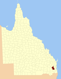
The County of Fitzroy is a county in Queensland, Australia. Like all counties in Queensland, it is a non-functional administrative unit, that is used mainly for the purpose of registering land titles.

Woodleigh is a village, parish and former manor located in the South Hams region of the county of Devon, England.

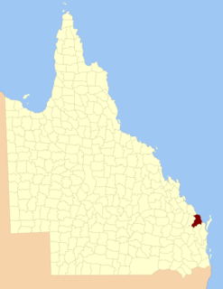
The County of Cardwell is a county in Far North Queensland, Queensland, Australia, between Cairns and Townsville. It was named and bounded by the Governor in Council on 7 March 1901 under the Land Act 1897. Its name likely honours Edward Cardwell, who was Secretary of State for the Colonies in 1864–1866 and later served as a reformist Secretary of State for War.
Avondale is a town and a locality in the Bundaberg Region, Queensland, Australia.
Good Night is a locality split between the Bundaberg Region and the North Burnett Region, Queensland, Australia.
