Coward Springs

Last updated

Coward Springs
Stuarts Creek,  South Australia
Coward Springs(GN05680).jpg
Coward Springs, ca. 1935
Australia South Australia location map.svg
Red pog.svg
Coward Springs
Coordinates 29°24′04″S136°48′42″E / 29.401087°S 136.811805°E / -29.401087; 136.811805 Coordinates: 29°24′04″S136°48′42″E / 29.401087°S 136.811805°E / -29.401087; 136.811805 [1]
Established1858
Elevation18 m (59 ft) [1]
Time zone ACST (UTC+9:30)
 • Summer (DST) ACDT (UTC+10:30)
Location236 km (147 mi) east of Coober Pedy
State electorate(s) Stuart [2]
Federal division(s) Grey [3]
FootnotesLocation [4]

Coward Springs is a former railway station of the Central Australia Railway and associated settlement in the Far North region of South Australia, west of Lake Eyre South.

Contents

The name refers to a nearby mound spring, situated on the Oodnadatta Track adjacent to the Wabma Kadarbu Mound Springs Conservation Park. The site is within the locality of Stuarts Creek, 236 km (147 mi) from Coober Pedy and 216 km (134 mi) from Coober Pedy. [1] [4] A camping ground is at the site, where the attractions include two heritage-listed buildings, the original bore, date palms and tamarisk trees.

Nomenclature and official status

The South Australian Commissioner of Police, Peter Warburton, named Coward Springs in 1858 after Corporal Thomas Coward. In 2019, Coward Springs's placename status was changed from "locality" to "mound spring". [5]

History

The South Australian government completed a 400-foot (120 m) borehole in 1886, [6] from which water from the Great Artesian Basin rose 15 feet (4.6 m) above ground. [7] The salty water corroded the bore head and casing, flowing uncontrolled to form a large pool and, by the 1920s, a wetland, in the dry gibber plain. It was reputed to be a popular place for local residents and – at a time when the railway's outback timetables had room for delays – train crews and passengers to cool off.

In 1993, the South Australian government redrilled and relined the bore, reducing the flow rate. The camping ground operators subsequently built a "natural spa" imitating the old pool, from which water was directed into the wetland.

The wetland created its own dynamics as an oasis providing water and food, shelter and breeding areas for a wide range of wildlife. As of 2008, the site was recorded as hosting 99 plant species, 126 bird species and numerous small native mammals, reptiles, aquatic and terrestrial invertebrates.

A school was opened in 1888, but it was closed in 1890. The Coward Springs Hotel, however, was licensed from 1887 to 1953. As trains pulled into the station, passengers were given directions to the "pub" and the "bath" for their choice of refreshment.

Camping ground and heritage-listed place

The quarters used by train crews at the end of their shifts, heritage-listed in 1998, are now restored Coward Springs engine drivers cabin.jpg
The quarters used by train crews at the end of their shifts, heritage-listed in 1998, are now restored

As of 2020, Coward Springs was privately operated as a campground and heritage area. At the behest of the operators, the "Coward Springs railway site" was listed in the South Australian Heritage Register in 1998. [8] The register cites the assets as:

a good example of an outback railway site in South Australia, being an important stopover for passengers travelling to Oodnadatta, as well as a stock and supply terminus. The date palms are a reminder of commercial ventures in the interior, and the tamarisk trees are examples of introduced species suitable for arid conditions. [note 1]

There are two restored stone railway buildings (a stationmaster's house, in private use, and train crew quarters), [note 2] two in-ground rainwater tanks, the original bore, date palms and tamarisk trees, also known as athel pines. [11]

Although the date palms reputedly were planted by pioneering "Afghan" cameleers, they are in fact remnants of two acres of date palms (variety Deglet Noor) planted in 1898 as part of a South Australian government experimental plantation. Surviving date palms from this plantation still produce fruit.

Notes

  1. Tamarisk trees were declared a weed of national significance as a consequence of their spread, most dramatically and noticeably in central Australia, after floods of 1974 along the Finke River in the Northern Territory. Before then, the species had been present for many decades without much spread. [9] [10]
  2. The register refers to an "engine driver's cabin". However, such quarters, usually termed "barracks" by the South Australian Railways regardless of their size, were routinely used by three people – driver, fireman and guard – and occasionally a fitter or other employee, to rest at the end of their work shift.

Related Research Articles

<span class="mw-page-title-main">Coober Pedy</span> Town in South Australia

Coober Pedy is a town in northern South Australia, 846 km (526 mi) north of Adelaide on the Stuart Highway. The town is sometimes referred to as the "opal capital of the world" because of the quantity of precious opals that are mined there. Coober Pedy is renowned for its below-ground dwellings, called "dugouts", which are built in this fashion due to the scorching daytime heat.

<span class="mw-page-title-main">William Creek, South Australia</span> Town in South Australia

William Creek, Australia is located halfway on the Oodnadatta Track, 210 km (130 mi) north west of Marree and 166 km (103 mi) east of Coober Pedy in South Australia. The town has a permanent population of 10. William Creek is in the federal Division of Grey and the state electorate of Stuart. It is outside of council areas, and administered by the Outback Communities Authority.

<span class="mw-page-title-main">Oodnadatta Track</span> Outback road in South Australia

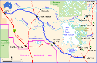
The Oodnadatta Track is an unsealed 614 km (382 mi) outback road in the Australian state of South Australia, connecting Marla in the north-west via Oodnadatta to Marree in the south-east. Along the way, the track passes the settlements of Oodnadatta and William Creek, the southern lake of the Kati Thanda-Lake Eyre National Park, and mound springs known as Freeling Springs, Strangways Springs, and The Bubbler and Blanche Cup.

<span class="mw-page-title-main">Oodnadatta</span> Town in South Australia

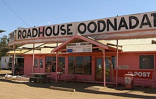
Oodnadatta is a small, remote outback town and locality in the Australian state of South Australia, located 1043 kilometres north-north-west of the state capital of Adelaide by road or 873 km (542 mi) direct, at an altitude of 112 metres. The unsealed Oodnadatta Track, an outback road popular with tourists, runs through the town. In the 2021 census, there were 74 dwellings and the population was 318.

<span class="mw-page-title-main">Anna Creek Station</span> Cattle station in South Australia

Anna Creek Station is the world's largest working cattle station. It is located in the Australian state of South Australia.

<span class="mw-page-title-main">Dalhousie Springs</span> Group of artesian aquifers in South Australia

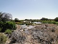
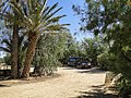
Dalhousie Springs, also known as Witjira-Dalhousie Springs, is a group of over 60 natural artesian springs located in Witjira National Park on the western fringe of the Simpson Desert, 180 kilometres northeast of Oodnadatta in northern South Australia. They are about 250 kilometres (160 mi) southeast of Alice Springs.

<span class="mw-page-title-main">Painted Desert (South Australia)</span>

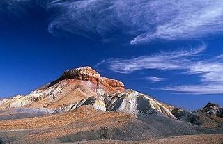
The Painted Desert is in the Far North of South Australia. It is 120 kilometres (75 mi) north-east of Coober Pedy, in the Arckaringa Station pastoral lease, not far from the homestead. It is notable for its distinctive mesas, mountains, and geological formations. Not far from here on the way to Oodnadatta, there are large areas of ground covered with mica. The entire region is desolate and made up of soft, fragile rock.

<span class="mw-page-title-main">District Council of Coober Pedy</span> Local government area in South Australia

The District Council of Coober Pedy is a local government area located around the opal mining town of the same name in Outback South Australia. The district's economy is based on the large opal deposits found beneath it, which have made it a major mining centre and also a popular tourist destination.

The Kanku-Breakaways Conservation Park, formerly known as The Breakaways Reserve or simply The Breakaways, is a protected area in northern South Australia, just off the Stuart Highway 33 km (21 mi) north of Coober Pedy.

<i>Tamarix aphylla</i> Species of plant

Tamarix aphylla is the largest known species of Tamarix, with heights up to 18 metres (59 ft). The species has a variety of common names, including Athel tamarisk, Athel tree, and Athel pine. It is an evergreen tree, native across North, East, and Central Africa, through the Middle East, and into parts of Western and Southern Asia.

<span class="mw-page-title-main">Pedirka Desert</span> Desert in central Australia

The Pedirka Desert is a small Australian desert, about 100 kilometres (62 mi) north-west of Oodnadatta and 250 kilometres (160 mi) north-east of Coober Pedy in South Australia. Mount Dare and Witjira National Park are just to the north.

<span class="mw-page-title-main">Arabana language</span> Australian Aboriginal language

Arabana or Arabuna is an Australian Aboriginal language of the Pama–Nyungan family, spoken by the Wongkanguru and Arabana people.
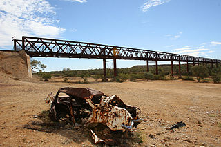
<span class="mw-page-title-main">Arckaringa Station</span> Pastoral lease in South Australia

Arckaringa Station is a pastoral lease in the Australian state of South Australia which that once operated as a sheep station but now operates as a cattle station.

<span class="mw-page-title-main">Wabma Kadarbu Mound Springs Conservation Park</span> Protected area in South Australia

Wabma Kadarbu Mound Springs Conservation Park is a protected area in the Australian state of South Australia. It is located in Stuarts Creek, about 130 kilometres north of the town of Marree via the Oodnadatta Track in the state's Far North. The conservation park was proclaimed under the National Parks and Wildlife Act 1972 in 1996. As of 2012, it is subject to a co-management agreement between the Arabana aboriginal people and the Department for Environment and Water.

<span class="mw-page-title-main">Stuarts Creek, South Australia</span> Town in South Australia

Stuarts Creek is a remote locality in the Australian state of South Australia in the states's Far North region. The name and boundaries were formalised on 26 April 2013, named after Stuart Creek Station, in respect of the long established local name.

Mount Willoughby is a locality in the Australian state of South Australia located about 837 kilometres north-west of the capital city of Adelaide and about 84 kilometres north-west of the town of Coober Pedy.

Oodnadatta is a town and locality in South Australia.

Allandale Station is a locality in the Australian state of South Australia located about 848 kilometres (527 mi) north of the state capital of Adelaide and about 20 kilometres (12 mi) south-east of the town of Oodnadatta.

Manguri Siding is located in the Adelaide–Darwin rail corridor at the locality of Mount Clarence Station, about 42 kilometres (26 mi) west of the opal mining town of Coober Pedy.

Mount Clarence Station is a locality in the Australian state of South Australia located about 771 kilometres (479 mi) north-west of the state capital of Adelaide and about 37 kilometres (23 mi) west of the town of Coober Pedy.

References

  1. 1 2 3 "Search results for 'Coward Springs Railway Station' with the following datasets being selected - 'Suburbs and Localities', 'Local Government Areas', 'SA Government Regions', 'Gazetteer' and 'Railways'". Location SA Map Viewer. Government of South Australia. Retrieved 21 March 2019.
  2. "District of Stuart Background Profile". Electoral Commission SA. Retrieved 20 August 2015.
  3. "Federal electoral division of Grey, boundary gazetted 16 December 2011" (PDF). Australian Electoral Commission. Retrieved 20 August 2015.
  4. 1 2 "How to get there". Coward Springs Campground. Retrieved 24 June 2008.
  5. "Search results for 'Coward Springs (Spring)' with the following datasets being selected - 'Suburbs and Localities', 'Local Government Areas', 'SA Government Regions' and 'Gazetteer'". Location SA Map Viewer. Government of South Australia. Retrieved 22 March 2019.
  6. "Coward Springs". Flinders Ranges Research. Retrieved 24 June 2008.
  7. "Place Names of South Australia - C". Manning Index of South Australian History. State Library of South Australia . Retrieved 24 June 2008.
  8. "Coward Springs Railway Site". South Australian Heritage Register. Department of Environment, Water and Natural Resources. Archived from the original on 15 February 2016. Retrieved 12 February 2016.
  9. Griffin, G.F.; Smith, D.M.S.; Morton, S.R.; Allan, G.E.; Masters, K.A.; Preece, N. (1989) 'Status and implications of the invasion of tamarisk (Tamarix aphylla ) on the Finke River, Northern Territory, Australia.' Journal of Environmental Management, 1989, vol. 29, no.4, 297–315
  10. "Weeds Australia - weeds of national significance - athel pine". weeds.org.au. Archived from the original on 12 September 2009. Retrieved 29 September 2009.
  11. "Heritage place details [Coward Springs Railway Site]". SA Heritage Places Database Search. Government of South Australia. 2020. Retrieved 31 October 2020.