
Pseudotsuga macrocarpa, commonly called the bigcone spruce or bigcone Douglas-fir, is an evergreen conifer native to the mountains of southern California. It is notable for having the largest cones in the genus Pseudotsuga, hence the name.

Ventura County is a county located in the southern part of the U.S. state of California. As of the 2020 census, the population was 843,843. The largest city is Oxnard, and the county seat is the city of Ventura.

Ojai is a city in Ventura County, California. Located in the Ojai Valley, it is northwest of Los Angeles and east of Santa Barbara. The valley is part of the east–west trending Western Transverse Ranges and is about 10 miles (16 km) long by 3 miles (5 km) wide and divided into a lower and an upper valley, each of similar size, surrounded by hills and mountains. The population was 7,637 at the 2020 census, up from 7,461 at the 2010 census.

The Santa Susana Mountains are a transverse range of mountains in Southern California, north of the city of Los Angeles, in the United States. The range runs east-west, separating the San Fernando and Simi valleys on its south from the Santa Clara River Valley to the north and the Santa Clarita Valley to the northeast. The Oxnard Plain is to the west of the Santa Susana Mountains.

The Santa Ynez Mountains are a portion of the Transverse Ranges, part of the Pacific Coast Ranges of the west coast of North America. It is the westernmost range in the Transverse Ranges.
Newbury Park is a populated place and town in Ventura County, California, United States. Most of it lies within the western Thousand Oaks city limits, while unincorporated areas include Casa Conejo and Ventu Park. The town is located in Southern California around 8 miles (13 km) from the Pacific Ocean and has a mild year-round climate, scenic mountains, and environmental preservation. About 28,000 residents of Thousand Oaks reside in Newbury Park.

Mount San Antonio, commonly referred to as Mount Baldy or Old Baldy, is a 10,064 ft (3,068 m) summit in the San Gabriel Mountains on the border of Los Angeles and San Bernardino counties of California. Lying within the San Gabriel Mountains National Monument and Angeles National Forest, it is the high point of the range, the County of Los Angeles, and the Los Angeles metropolitan area.
Los Padres National Forest is a United States national forest in southern and central California. Administered by the United States Forest Service, Los Padres includes most of the mountainous land along the California coast from Ventura to Monterey, extending inland. Elevations range from sea level to 8,847 feet (2,697 m).
California's 24th congressional district is a congressional district in the U.S. state of California. The district is currently represented by Salud Carbajal. It contains all of Santa Barbara County, most of San Luis Obispo County, and part of Ventura County. Cities in the district include Santa Barbara, Ventura, San Luis Obispo, Santa Maria, and Ojai.
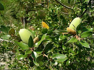
Quercus chrysolepis, commonly termed canyon live oak, canyon oak, golden cup oak or maul oak, is a North American species of evergreen oak that is found in Mexico and in the western United States, notably in the California Coast Ranges. This tree is often found near creeks and drainage swales growing in moist cool microhabitats. Its leaves are a glossy dark green on the upper surface with prominent spines; a further identification arises from the leaves of canyon live oak being geometrically flat.

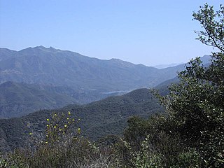
The Dick Smith Wilderness is a wilderness area in the mountains of eastern Santa Barbara County, California, United States, with a portion in Ventura County. It is completely contained within the Los Padres National Forest, and is northeast of the city of Santa Barbara and north of the city of Ojai. It is most easily accessible from two trailheads off State Route 33, which runs north from Ojai. It is adjacent to the large San Rafael Wilderness on the west and the Matilija Wilderness on the south. Across Highway 33 to the east, and also in the Los Padres National Forest, is the large Sespe Wilderness.

The Kiavah Wilderness is a federally designated wilderness area located in the Mojave Desert, Scodie Mountains, and southern Sierra Nevada in Kern County, California, United States. California State Route 178 connects the town of Lake Isabella to State Highway 14 in the east, crossing Walker Pass at the north boundary of the wilderness.

The California montane chaparral and woodlands is an ecoregion defined by the World Wildlife Fund, spanning 7,900 square miles (20,000 km2) of mountains in the Transverse Ranges, Peninsular Ranges, and Coast Ranges of southern and central California. The ecoregion is part of the larger California chaparral and woodlands ecoregion, and belongs to the Mediterranean forests, woodlands, and scrub biome.
The flora of the Colorado Plateau and Canyonlands region is generally characterized by plant adaptations to the arid conditions of the region, and a wide variation of plant communities from wide variations in elevation and soil types. The elevation variation results in temperature variation. Differing soil types are largely due to erosion of different sedimentary layers in the canyons, from the layers at lowest point of canyons of the Colorado River network, to the top layers of the plateau. Exceptions to flora adapted to aridity occur in lowland riparian areas, at springs, and in hanging gardens.
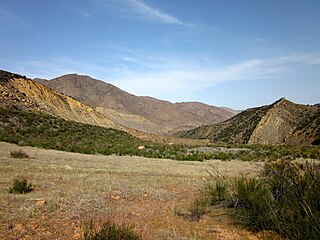
The Sespe Wilderness is a 219,700-acre (88,900 ha) wilderness area in the eastern Topatopa Mountains and southern Sierra Pelona Mountains, within the Los Padres National Forest (LPNF), in Ventura County, Southern California. The wilderness area is primarily located within the Ojai and Mt. Pinos ranger districts of the LPNF.

Deer Ridge Open Space is a 188-acre public-owned open-space area in the southwest portion of the town of Newbury Park, California. It contains a series of north-facing mountainous ridges and canyons, dominated by chaparral and oak trees. It shares borders with the Santa Monica Mountains National Recreation Area to the south, and the Los Robles Trail traverses the length of Deer Ridge Open Space. Its main trailhead is located on Potrero Road, while a smaller access point is located at the southern end of Felton Street. The Los Robles Trail is the Conejo Open Space Conservation Agency’s longest trail, and connects to open-space areas and parks such as the Los Padres Open Space, Conejo Ridge Open Space, Hope Nature Preserve, Old Conejo Open Space, and the Los Vientos Open Space. The trail in Newbury Park provides panoramic views of the Conejo Valley and Santa Monica Mountains, before entering the Hope Nature Preserve. The Los Robles Trail provides more than 25 miles of contiguous trails connecting Newbury Park to Westlake Village in Los Angeles County. Immediately south of the Deer Ridge Open Space in Newbury Park are the Hidden Valley and Rancho Sierra Vista Satwiwa.

Ventu Park Open Space is a 141-acre open space area in Newbury Park, California. Its primary features are the Rosewood Trail leading to Angel Vista, a 1,603 ft peak in the Santa Monica Mountains. Parking for the Rosewood Trail is located at the Stagecoach Inn Park, across Lynn Road from the primary trailhead. The Rosewood Trail begins with oak woodland and crosses a creek at the canyon floor, before climbing up towards the steep Angel Vista Point. There are 360-degree panoramic views of the Conejo Valley, the Oxnard Plain, the California Channel Islands, Pacific Ocean, Point Mugu, Hidden Valley, as well as the Santa Monica-, Santa Susana- and Topa Topa Mountains.

Wheeler Springs is an unincorporated community that grew around a set of sulphurated hot springs in Ventura County, California. It is located 6 miles north of the Ojai Valley, within Los Padres National Forest. It is named for Wheeler Blumberg, who founded the town in 1891, and the many natural hot springs.
The Matilija Wilderness is a 29,207-acre (11,820 ha) wilderness area in Ventura and Santa Barbara Counties, Southern California. It is managed by the U.S. Forest Service, being situated within the Ojai Ranger District of the Los Padres National Forest. It is located adjacent to the Dick Smith Wilderness to the northwest and the Sespe Wilderness to the northeast, although it is much smaller than either one. The Matilija Wilderness was established in 1992 in part to protect California condor habitat.


