Related Research Articles

The Bhimbetka rock shelters are an archaeological site in central India that spans the prehistoric Paleolithic and Mesolithic periods, as well as the historic period. It exhibits the earliest traces of human life in India and evidence of Stone Age starting at the site in Acheulian times. It is located in the Raisen District in the Indian state of Madhya Pradesh about 45 kilometres (28 mi) south-east of Bhopal. It is a UNESCO World Heritage Site that consists of seven hills and over 750 rock shelters distributed over 10 km (6.2 mi). At least some of the shelters were inhabited more than 100,000 years ago. The rock shelters and caves provide evidence of, according to Encyclopædia Britannica, a "rare glimpse" into human settlement and cultural evolution from hunter-gatherers, to agriculture, and expressions of prehistoric spirituality.

The Monongahela National Forest is a national forest located in the Allegheny Mountains of eastern West Virginia, USA. It protects over 921,000 acres of federally owned land within a 1,700,000 acres proclamation boundary that includes much of the Potomac Highlands Region and portions of 10 counties.

The George Washington and Jefferson National Forests is an administrative entity combining two U.S. National Forests into one of the largest areas of public land in the Eastern United States. The forests cover 1.8 million acres (7,300 km2) of land in the Appalachian Mountains of Virginia, West Virginia, and Kentucky. Approximately 1 million acres (4,000 km2) of the forest are remote and undeveloped and 139,461 acres (564 km2) have been designated as wilderness areas, which eliminates future development.

The Gauley River is a 105-mile-long (169 km) river in West Virginia. It merges with the New River to form the Kanawha River, a tributary of the Ohio River. The river features numerous recreational whitewater areas, including those in Gauley River National Recreation Area downstream of the Summersville Dam.

The Williams River is a tributary of the Gauley River, 33 miles (53 km) long, in east-central West Virginia, USA. Via the Gauley, Kanawha and Ohio Rivers, it is part of the watershed of the Mississippi River, draining an area of 132 square miles (342 km²) in a sparsely populated region of the southern Allegheny Mountains and the unglaciated portion of the Allegheny Plateau.
West Virginia Route 150 is a 22.5-mile (36.2 km) long north–south scenic state highway in the Marlinton and Gauley Ranger Districts of the Monongahela National Forest in southeast West Virginia. The southern terminus of the route is at West Virginia Route 39 and West Virginia Route 55 northwest of Mill Point. The northern terminus is at U.S. Route 219 and WV 55 north of Edray, near Marlinton.

The Cranberry River is a tributary of the Gauley River located in southeastern West Virginia in the United States. It is a part of the Mississippi River watershed, by way of the Gauley, Kanawha, and Ohio Rivers, draining an area of 74 square miles (192 km2).

Summit Lake is a 43-acre (170,000 m2) cold water reservoir located in Greenbrier County, West Virginia in the Gauley Ranger District of the Monongahela National Forest. The reservoir is formed by the impoundment of the waters of two forks of Coats Run, a small tributary of the North Fork of the Cherry River. There have been attempts to rename the lake in honor of Carl E. Gainer, a politician from nearby Richwood. These efforts, however, have had limited success with local residents and the United States Forest Service.
Meadowcroft Rockshelter is an archaeological site located near Avella in Jefferson Township, Washington County, Pennsylvania, United States. The site is a rock shelter in a bluff overlooking Cross Creek, and contains evidence that the area may have been continually inhabited for more than 19,000 years. If accurately dated, the site would be the earliest known evidence of human presence and the longest sequence of continuous human occupation in the New World.
Carnifex Ferry Battlefield State Park is an American Civil War battle site that commemorates the Battle of Carnifex Ferry. It is located on the rim of the Gauley River Canyon near Summersville, a town in Nicholas County, West Virginia. The 156-acre (0.63 km2) park features Patterson House Museum, three views of the Gauley River, hiking trails and picnic facilities. It is one of the oldest state parks in the United States. A Civil War re-enactment takes place on a weekend after Labor Day. As Carnifex Ferry State Park, it was listed on the National Register of Historic Places in 1974.

Gatecliff Rockshelter (26NY301) is a major archaeological site in the Great Basin area of the western United States that provides remarkable stratigraphy; it has been called the "deepest archaeological rock shelter in the Americas". Located in Mill Canyon of the Toquima Range in the Monitor Valley of central Nevada, Gatecliff Rockshelter has an elevation of 7,750 feet (2,360 m). David Hurst Thomas discovered Gatecliff Rockshelter in 1970 and began excavations in 1971. Full scale excavations occurred at Gatecliff Rockshelter for about seven field seasons in which nearly 33 feet (10 m) of sediments were exposed for a well-defined stratigraphic sequence. The well-preserved artifacts and undisturbed sediments at Gatecliff Rockshelter provides data and information have been applied to a range of research topics. Based on the analysis of the artifacts at Gatecliff Rockshelter, it can be determined that it was most likely a short-term field camp throughout prehistory. The latest evidence for human usage at Gatecliff occurs between ca. 5500 B.P. to 1250 B.P.

Barton Village Site, also known as the Herman Barton Indian Village Archeological Site, is a large, multi-component archaeological site near Cumberland in Allegany County, Maryland.

This is a list of the National Register of Historic Places listings in Randolph County, West Virginia.

This is a list of the National Register of Historic Places listings in Pocahontas County, West Virginia.

The LoDaisKa Site is a prominent archaeological site in the U.S. state of Colorado, located within a rockshelter near Morrison. The rockshelter was first inhabited by people of the Archaic through the Middle Ceramic period, generally spanning 3000 BC to 1000 AD.

Site AU-154 is an archaeological site in Shenandoah National Park, in Augusta County, Virginia, United States.

The Paine Run Rockshelter (44-AU-158) is an archaeological site in Shenandoah National Park, in Augusta County, Virginia, United States.

The Rockhouse Cliffs Rockshelters are a pair of rockshelters in the far southern region of the U.S. state of Indiana. Located amid broken terrain in the Hoosier National Forest, the shelters may have been inhabited for more than ten thousand years by peoples ranging from the Early Archaic period until the twentieth century. As a result of their extensive occupation and their remote location, they are important and well-preserved archaeological sites and have been named a historic site.
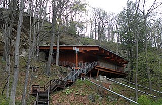
Laurel Run Rockshelter is a historic archaeological site located near Coe, Webster County, West Virginia. It is one of a number of prehistoric rock shelters on the Gauley Ranger District, Monongahela National Forest, that are known to have been utilized prehistorically from the Middle Archaic through the Late Woodland period, c. 6000 B.C.-1200 A.D. There are some indications that the Laurel Run rock shelter may have been utilized during the Early Archaic period, c. 8000-6000 B. C.

The Hidden Valley Rockshelter (44-BA-31) is a significant archaeological site located near the community of Warm Springs in Bath County, Virginia, United States. A large rockshelter located near the Jackson River, it has been occupied by humans for thousands of years, and it has been named a historic site.
References
- 1 2 "National Register Information System". National Register of Historic Places . National Park Service. July 9, 2010.
- ↑ Anne M. Jensen (January 1993). "National Register of Historic Places Inventory Nomination Form: Rockshelters on the Gauley Ranger District, Monongahela National Forest" (PDF). State of West Virginia, West Virginia Division of Culture and History, Historic Preservation.