
Blaenau Ffestiniog is a town in Gwynedd, Wales. Once a slate mining centre in the historic county of Merionethshire, it now relies heavily on tourists, drawn for instance by the Ffestiniog Railway and Llechwedd Slate Caverns. Blaenau Ffestiniog was once the second largest town in North Wales, behind only Wrexham. After reaching 12,000 at the peak development of the slate industry, it fell with the decline in demand for its slate. The population of the community of Ffestiniog, including the nearby village Llan Ffestiniog, was 4,875 according to the 2011 census: the fourth most populous community in Gwynedd after Bangor, Caernarfon and Llandeiniolen. Llan Ffestiniog's population of 864 puts the population of Blaenau itself at around 4,000.

Tanygrisiau is a village and area within Blaenau Ffestiniog in the upper end of the Vale of Ffestiniog in the county of Gwynedd, north-west Wales. It can be found along the southern side of the Moelwyn mountain range and dates to around 1750. It joins onto the semi-urban area of Blaenau Ffestiniog, and is in the community of Ffestiniog; located between 650 feet (200 m) and 750 feet (230 m) above sea level. it is in the electoral ward of Bowydd and Rhiw which had a 2011 census population of 1878.

The River Dwyryd is a river in Gwynedd, Wales which flows principally westwards; draining to the sea into Tremadog Bay, south of Porthmadog.
West Wales is not clearly defined as a particular region of Wales. Some definitions of West Wales include only Pembrokeshire, Ceredigion and Carmarthenshire, which historically comprised the Welsh principality of Deheubarth and was called "South West Wales" in the Nomenclature of Territorial Units for Statistics (NUTS). Other definitions include Swansea and Neath Port Talbot but exclude Ceredigion. The "West Wales and the Valleys" NUTS area includes more westerly parts of North Wales.

Merthyr Mawr is a village and community in Bridgend, Wales. The village is about 2½ miles from the centre of Bridgend town. The population of the community at the 2011 census was 267. The community occupies the area west of the Ewenny River, between Bridgend and Porthcawl. It takes in the settlement of Tythegston and a stretch of coastal sand dunes known as Merthyr Mawr Warren. It is in the historic county of Glamorgan.

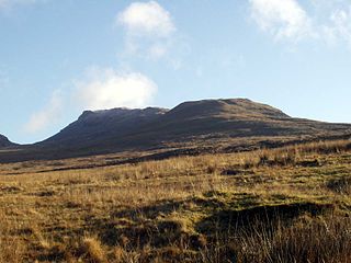
Moelwyn Mawr is a mountain in Snowdonia, North Wales and forms part of the Moelwynion. Its summit overlooks the Vale of Ffestiniog and has views in all directions.
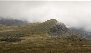
Moelwyn Bach is a mountain in Snowdonia, northern Wales and forms part of the Moelwynion. It is connected to its parent peak Moelwyn Mawr via the Craigysgafn ridge.
Moel-yr-hydd is a subsidiary summit of Moelwyn Mawr in Snowdonia, North Wales and forms part of the Moelwynion.

Manod Mawr is a mountain in North Wales and forms part of the Moelwynion. Although known as a mountain in the eastern Moelwyns, it and its sister peaks are sometimes known as the Ffestiniog hills.

The Moelwynion are a group of mountains in central Snowdonia. They extend from the north-east of Porthmadog to Moel Siabod, the highest of the group. The name derives from the names of the two largest mountains in the group, Moelwyn Mawr and Moelwyn Bach.

The Ffestiniog Power Station is a 360-megawatt (480,000 hp) pumped-storage hydroelectricity scheme near Ffestiniog, in Gwynedd, north-west Wales, United Kingdom. The power station at the lower reservoir has four water turbines, which can generate 360 megawatts of electricity within 60 seconds of the need arising. The scheme has the capacity to power the whole of North Wales for several hours.

Pegwn Mawr is a mountain in Powys, Mid Wales, east of Llanidloes. It is 586 m (1,922 ft) high. It is surrounded by a wind farm. There is a trig point (pictured)

Manod Mawr North Top is a mountain in North Wales and forms part of the Moelwynion.

Moelwyn Mawr North Ridge Top is a top of Moelwyn Mawr in Snowdonia, North Wales and forms part of the Moelwynion. From its summit, which directly overlooks Bwlch Rhosydd, can be seen Cnicht, Allt-fawr and Moel-yr-hydd. A recently discovered 'top' has only received attention from Nuttall baggers.
Coedydd Maentwrog, on the north side of the Vale of Ffestiniog, is the largest wood in the Vale. The national nature reserve consists of two separate sections: Coed Llyn Mair, and a group of three forests. It offers a variety of habitats, rising from the wooded valley onto open moorland and reaching towards the foot of Moelwyn Bach mountain. A nature trail and a network of public footpaths are features of the reserve. Animals such as the rare lesser horseshoe bat and the wood warbler can be spotted here, and the gorge is noted for its liverworts and lichens.
Hafod Garegog National Nature Reserve is a national nature reserve located near the village of Nantmor, about 6 kilometres north of Porthmadog in Gwynedd.

Y Gamallt is a mountain located in the Migneint in Snowdonia, North Wales. It forms part of the Arenig mountain range being separated from the Moelwynion range at the head of Cwm Teigl.

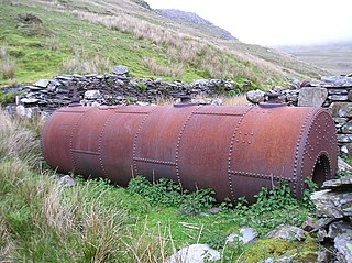
Moelwyn quarry is a defunct slate quarry located to the south of the village of Tanygrisiau, north Wales. Some initial prospecting was carried out in the 1820s and again in the 1840s, but it was 1860 before a company was formed, and chambers were excavated. The quarry was never a financial success, and operated sporadically until its demise in 1897. Despite the poor results, a spectacular series of seven inclines were constructed, to enable slates to reach the Ffestiniog Railway. The quarry was hampered by lack of a good water supply, and the mill was constructed between inclines 4 and 5, where water could be obtained from Llyn Stwlan. As in many quarries, barracks were provided, but these were occupied by whole families, living on the mountain, rather than used as lodgings for the quarrymen during the working week. Even in its remote location, there was still a concern for education, with basic literacy classes being run in the 1860s.
Fron-Boeth and Pant Mawr quarries were two closely related and interconnected quarries on the western slopes of Moelwyn Mawr in Gwynedd, North Wales. Pant Mawr operated from around 1850 to 1879, and was partly re-opened in 1886 when it was amalgamated with Fron-Boeth. Both quarries closed during the First World War. Finished product was transported to the slate quays of Porthmadog by the Croesor Tramway.
Mawr is a community in south Wales. Mawr means big or great in Welsh and may also refer to the following Wales-related topics:
