Anne Caroline Ballingall McIntosh, Baroness McIntosh of Pickering is a British politician who has been a life peer since 2015.
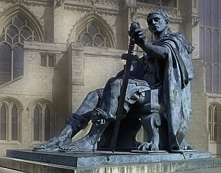
Eboracum was a fort and later a city in the Roman province of Britannia. In its prime it was the largest town in northern Britain and a provincial capital. The site remained occupied after the decline of the Western Roman Empire and ultimately developed into the present-day city of York, in North Yorkshire, England.

Malton is a market town, civil parish and electoral ward in North Yorkshire, England. Historically part of the North Riding of Yorkshire, the town has a population measured for both the civil parish and the electoral ward at the 2011 Census as 4,888.

The A64 is a major road in North and West Yorkshire, England, which links Leeds, York and Scarborough. The A64 starts as the A64(M) ring road motorway in Leeds, then towards York it becomes a high-quality dual carriageway until it is east of the city, where it becomes a single carriageway for most of its route to Scarborough.

Welburn is a village and civil parish in North Yorkshire, England, on the north bank of the River Derwent. It lies on the edge of the Howardian Hills, near to the stately home Castle Howard. It is about 14 miles from York and 5 miles south-west of Malton/Norton. It is a popular area for walkers and bird-watchers. The parish's population was estimated at 523 people in 2013. This figure includes the developments at Crambeck, Holmes Crescent and Chestnut Avenue that are some distance outside the heart of the village.

The Vale of Pickering is a low-lying flat area of land in North Yorkshire, England. It is drained by the River Derwent. The landscape is rural with scattered villages and small market towns. It has been inhabited continuously from the Mesolithic period. The present economy is largely agricultural with light industry and tourism playing an increasing role.

Norton-on-Derwent, commonly referred to as simply Norton, is a town and civil parish in North Yorkshire, England. Norton borders the market town of Malton, and is separated from it by the River Derwent. The 2001 Census gave the population of the parish as 6,943, increasing at the 2011 Census to 7,387.

Bulmer is a village and civil parish in North Yorkshire, England. According to the 2001 census it had a population of 174, increasing to 202 at the census 2011. The village is about 7 miles (11 km) south-west of Malton.

Stockton-on-the-Forest is a village and civil parish in the unitary authority of the City of York in North Yorkshire, England.

The A1237 road is a road that runs to the west and north of the city of York, England. It forms part of the York Outer Ring Road as either end of the route forms junctions with the A64 to the south-west and east of the city to act as a city distributor. Construction began in 1984 and consisted of three distinct building phases. The road took three years to complete and has been subject since to studies looking to improve traffic flow and reduce accidents. The National Speed Limit for an A Class Road applies.

Crambe is a village and civil parish in the Ryedale district of North Yorkshire, England. It is near the River Derwent and 6 miles (10 km) south-west of Malton. The population as of the 2011 census was less than 100. Details are included in the civil parish of Whitwell-on-the-Hill. The village is located in the Howardian Hills Area of Outstanding Natural Beauty. The father of the renowned mathematician Karl Pearson was born in the village.

Old Malton is a village in the civil parish of Malton, in North Yorkshire, England. The village is situated just south of the A64 road and is 1-mile (1.5 km) north-east of the town of Malton. The village is on the B1257 which links Malton with the A64 and the A169 road to the north and is bounded on its eastern side by the River Derwent.
Dales ware is a type of pottery produced in the South Yorkshire and Lincolnshire areas of England and widely distributed across northern Britain during the 3rd and 4th centuries AD.
Scagglethorpe is a village and civil parish in the Ryedale district of North Yorkshire, England. It is situated just south from the A64 road, 3 miles (5 km) east from Malton and almost midway between York and Scarborough.

Huttons Ambo is a civil parish in the former Ryedale district of North Yorkshire, England. It is about 14 miles (22.5 km) north-east of York and 3 miles (4.8 km) south-west of Malton. The civil parish of Huttons Ambo consists of the villages of High Hutton and Low Hutton.

Philip Corder was a British archaeologist and curator, and president (1954-1957) of the Royal Archaeological Institute.

John Lamplugh Kirk MRCS was a British medical doctor, amateur archaeologist and founder of York Castle Museum in York, North Yorkshire.
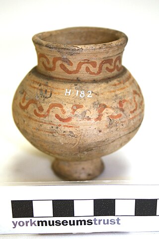
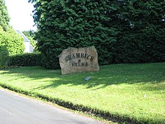
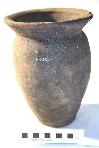
Crambeck Ware is a type of Romano-British ceramic produced in North Yorkshire primarily in the 4th century AD.

Derventio, sometimes described as Derventio Brigantium in order to distinguish it from other places called Derventio, was a Roman fort and settlement located beneath the modern town of Malton in North Yorkshire, England. The fort is positioned 18 miles north-east of Eboracum on the River Derwent.

The A169 is an A road in North Yorkshire, England. It runs from the A64 at Malton on the edge of the Yorkshire Wolds through the Vale of Pickering and across the North York Moors to join the A171 just west of Whitby. It is a single carriageway for all of its 25-mile (40 km) route. Whilst it is not considered a Primary Route nationally, the Ryedale Local Transport Plan lists it as part of its Major Road Network alongside the A64, A166 and A171.