Mount Adams, known by some Native American tribes as Pahto or Klickitat, is an active stratovolcano in the Cascade Range. Although Adams has not erupted in more than 1,000 years, it is not considered extinct. It is the second-highest mountain in Washington, after Mount Rainier.

Boulder Glacier is located on the southeast slope of Mount Baker, a stratovolcano near the Pacific coast of North America in the Cascade Range of Washington. Boulder Glacier is the sixth largest on Mount Baker with an area of 1.3 square miles (3.4 km2). It flows from the summit crater between Grant Peak and Sherman Peak to about 5,000 ft (1,500 m). It is noteworthy for retreating 1,610 ft (490 m) between 1987 and 2008, leaving newly exposed rock and soil behind.
The Sør Rondane Mountains are a group of mountains about 100 miles (160 km) long with main peaks rising to 3400 m, between the Queen Fabiola Mountains and Wohlthat Mountains in Queen Maud Land. They were discovered and photographed from the air by members of the Lars Christensen Expedition (LCE) on February 6, 1937, and named after Rondane, a mountain massif in southern Norway. The mountains and their constituent features were mapped in greater detail and named in 1957 by Norwegian cartographers working with air photos taken by U.S. Navy Operation Highjump, 1946–47.

Fryingpan Glacier is on the eastern face of the 11,138-foot (3,395 m) Little Tahoma Peak, just to the east of Mount Rainier in the U.S. state of Washington. The glacier is located on top of a cliff from the Emmons Glacier to the north and a small ridge separates this glacier from the Whitman Glacier to the south, except for a small snowfield in which these two glaciers are connected. Most of the ice is located on a broad plateau at an elevation of 8,000 to 8,600 feet. The head of the Fryingpan Glacier is located to the northeast of the ridge and at the foothill of Little Tahoma Peak at around 9,100 to 9,800 feet. The glacier flows downhill eastward and the uneven topography causes the glacier surface to be crevassed The glacier ends on shallow to steep slopes at about 7,100 to 7,500 feet. Numerous snowfields and alpine meadows are located near the bottom and east of the glacier. Meltwater from the glacier drains into the White River.
Edmunds Glacier is located on Mount Rainier in the U.S. state of Washington. Named in 1883 for Vermont senator George F. Edmunds, the glacier lies on the western flank of the volcano below the steep, rocky Mowich Face and Sunset Face. Starting from an elevation of about 9,900 ft (3,000 m), the glacier flows northwest down to 7,000 ft (2,100 m) and ends northeast of the Jeanette Heights region of Mount Rainier. Meltwater from the Edmunds Glacier feeds the Mowich River which eventually merges with the Puyallup River.

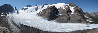
Adams Glacier is situated on the northwest flank of Mount Adams, a 12,281-foot (3,743 m) stratovolcano in the U.S. state of Washington. Much of it becomes the source of Adams Creek, a tributary of the Cispus River. It is the largest glacier on Mount Adams. It flows down from the summit ice cap at over 12,000 feet (3,700 m) for over 2.5 miles (4.0 km) to a terminus near 7,000 feet (2,100 m).
Rusk Glacier is located on the eastern face of Mount Adams in the U.S. state of Washington. Starting at an elevation of over 10,200 ft (3,100 m) at just below The Castle, the glacier flows eastward down slope. A significant portion of the glacier is covered by rock debris and in the middle of the glacier, at about 9,200 ft (2,800 m), there is a small ice-free island of rock. The glacier terminates at about 7,500 ft (2,300 m) at its rock-covered moraine. The glacier has decreased in surface area by 23 percent between 1904 and 2006.
Blue Glacier is a large glacier located to the north of Mount Olympus in the Olympic Mountains of Washington. The glacier covers an area of 1.7 sq mi (4.4 km2) and contains 580,000,000 cu ft (16,000,000 m3) of ice and snow in spite of its low terminus elevation. The glacier length has decreased from about 3.4 mi (5.5 km) in 1800 to 2.7 mi (4.3 km) in the year 2000. Just in the period from 1995 and 2006, Blue Glacier retreated 325 ft (99 m). Blue Glacier is also thinning as it retreats and between 1987 and 2009 the glacier lost 178 ft (54 m) of its depth near its terminus and between 32 and 48 ft in the uppermost sections of the glacier known as the accumulation zone.

White Glacier is located on the north slopes of Mount Tom in the Olympic Mountains and Olympic National Park in the U.S. state of Washington. The main portion of the glacier heads at around 7,000 and 6,400 feet in a cirque just under the summit rocks, while the westernmost section of White Glacier is partially separated from the rest of the glacier by several small ridges of rock and flows straight north. The principle portion of the glacier flows north as well, with a glacier toe descending to around 4,800 feet (1,500 m) where the toe turns northeast to its terminus at 4,400 feet (1,300 m). Steep ridges of rock separate an eastern portion of the White Glacier from the Blue Glacier cirque on adjacent Mount Olympus, to the east.
Explorers Range is a large mountain range in the Bowers Mountains of Victoria Land, Antarctica, extending from Mount Bruce in the north to Carryer Glacier and McLin Glacier in the south.
White Salmon Glacier is located on Mount Adams in the U.S. state of Washington. The glacier starts southwest of the summit crater at an elevation of 11,600 ft (3,500 m). Ice flows southwest downhill until the glacier's terminus at about 9,600 ft (2,900 m) elevation. The glacier also contributes ice to the much larger Avalanche Glacier at an elevation of 10,200 ft (3,100 m). White Salmon Glacier has decreased in surface area by 86 percent between 1904 and 2006.
The Batterbee Mountains are a group of prominent mountains rising to 2,200 metres (7,200 ft), which forms part of the dissected edge of Dyer Plateau overlooking George VI Sound, on the west coast of Palmer Land. First seen and photographed from the air by Lincoln Ellsworth on 23 November 1935, they were charted from the ground in October 1936 by the British Graham Land Expedition (BGLE) under John Rymill, and named after Sir Harry Batterbee (1880–1976), Assistant Under-Secretary of State, Dominions Office, 1930–38, and Chairman of the Polar Committee in 1934, who gave help to the expedition.

Avalanche Glacier is located on the west to southwest slopes of Mount Adams a stratovolcano in the Gifford Pinchot National Forest in the U.S. state of Washington. The glacier descends from the White Salmon Glacier at 10,200 ft (3,100 m) to a terminus near 7,600 ft (2,300 m). Avalanche Glacier has been in a general state of retreat for over 100 years and lost 59 percent of its surface area between 1904 and 2006.
Gotchen Glacier is located on the south slopes of Mount Adams, a stratovolcano in the Gifford Pinchot National Forest in the U.S. state of Washington. The glacier descends from approximately 8,200 ft (2,500 m) to a terminus near 7,400 ft (2,300 m) below, where an old terminal moraine and proglacial lake exist. Gotchen Glacier has been in a general state of retreat for over 100 years and lost 78 percent of its surface area between 1904 and 2006.
Klickitat Glacier is located on the east slopes of Mount Adams a stratovolcano in the U.S. state of Washington. Though within the Mount Adams Wilderness, the glacier is situated within the boundaries of the Yakama Indian Reservation. The glacier descends from approximately 12,000 ft (3,700 m) to a terminus near 7,200 ft (2,200 m) below which an old lateral moraine once was the northern margin of the glacier. Klickitat Glacier has been in a general state of retreat for over 100 years and lost 46 percent of its surface area between 1904 and 2006.
Lava Glacier is located on the north slopes of Mount Adams a stratovolcano in Gifford Pinchot National Forest in the U.S. state of Washington. The glacier descends from approximately 10,000 ft (3,000 m) to a terminus near 7,800 ft (2,400 m). Lava Glacier has been in a general state of retreat for over 100 years and lost 74 percent of its surface area between 1904 and 2006.

Lyman Glacier is located on the north slopes of Mount Adams a stratovolcano in Gifford Pinchot National Forest in the U.S. state of Washington. The glacier is also within the Yakama Indian Reservation and descends from near the summit of Mount Adams at approximately 11,400 ft (3,500 m) to a terminus near 7,800 ft (2,400 m). Below 9,000 ft (2,700 m) the glacier splits into three distinct lobes. Lyman Glacier has been in a general state of retreat for over 100 years and lost 34 percent of its surface area between 1904 and 2006.

Mazama Glacier is located on the southeast slopes of Mount Adams, a stratovolcano in the U.S. state of Washington. Mazama Glacier is in the Yakama Indian Reservation. The glacier descends from approximately 10,800 ft (3,300 m) to a terminus near 7,600 ft (2,300 m). Mazama Glacier has been in a general state of retreat for over 100 years and lost 46 percent of its surface area between 1904 and 2006.
Pinnacle Glacier is located on the west slopes of Mount Adams a stratovolcano in Gifford Pinchot National Forest in the U.S. state of Washington. The glacier descends from approximately 10,000 ft (3,000 m) to a terminus near 7,200 ft (2,200 m). Pinnacle Glacier lost 7 percent of its surface area between 1904 and 2006.
Wilson Glacier is located on the east slopes of Mount Adams, a stratovolcano in the U.S. state of Washington. The glacier is within the Yakama Indian Reservation. The glacier descends from approximately 10,600 ft (3,200 m) to a terminus near 7,400 ft (2,300 m). Wilson Glacier has been in a general state of retreat for over 100 years and lost 14 percent of its surface area between 1904 and 2006.