
The Shiawassee National Wildlife Refuge is a 9,870.35 acres (39.9439 km2) National Wildlife Refuge in Saginaw County managed by the United States Fish and Wildlife Service. It is located in the central portion of the lower peninsula of the U.S. state of Michigan, approximately 25 miles (40 km) south of the Saginaw Bay in Lake Huron and five miles (8 km) south of the city of Saginaw in the county's Spaulding and James townships. It was established in 1953 to provide habitat for migratory waterfowl.
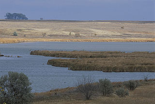
Huron Wetland Management District is located in the U.S. state of South Dakota and includes 17,518 acres (70.89 km2). The refuge borders the Missouri River on the east and is managed by the U.S. Fish and Wildlife Service. Huron WMD covers eight counties in east-central South Dakota. The topography of this area ranges from flat, gently rolling drift prairie to the Missouri Coteau hills in the western end of the district. The district lies in the midst of the Prairie Pothole Region.
Lake Andes Wetland Management District is located in the U.S. state of South Dakota and includes 82,731 acres (334 km2). The refuge is managed by the U.S. Fish and Wildlife Service. Of the land area in the district, the U.S. Government owns only 19,177 acres (77.6 km2), while the remaining area is managed as an easement to help protect Waterfowl Production Areas from future development. The district oversees numerous wetland zones in an effort to ensure species protection. During Spring and Fall migration periods, tens of thousands of migratory birds can be found here, representing over 100 different species. The district is a part of the Lake Andes National Wildlife Refuge Complex. Bald eagles, northern pintail, mallards, snow geese, great grey owl, American kestrel, red-tailed hawk and prairie chicken are some of the more impressive bird species that can be found in the district.
Madison Wetland Management District is located in the U.S. state of South Dakota and includes 129,700 acres (524 km2). 38,500 acres (155 km2) is owned by the U.S. Government while the remaining area is protected through easements in agreement with the state and other entities. The refuge is managed by the U.S. Fish and Wildlife Service. The wetlands are a part of the Prairie Pothole Region, well known to be an outstanding natural resource area that is vital for migratory bird species. As the Great Plains were being plowed under, conservationists groups worked towards ensuring wetlands would be preserved to protect these areas. Now known as Waterfowl Production Areas, preservation of this region helps to ensure a sustainable population of hundreds of migratory bird species and other plant and animal species dependent on this ecosystem.
Sand Lake National Wildlife Refuge is located in the northeastern part of the U.S. state of South Dakota and is administered by the U.S. Fish and Wildlife Service. Created in 1935, it is a wetland of international importance and a Globally Important Bird Area. Over 260 bird species are found in the refuge, including many migratory bird species and the world's largest breeding colony of Franklin's gulls.

Arrowwood National Wildlife Refuge is located in the U.S. state of North Dakota. Arrowwood NWR is a part of the Arrowwood National Wildlife Refuge Complex, and is managed by the U.S. Fish and Wildlife Service. The refuge parallels 16 miles (27 km) of the James River and is a mixture of wetlands, forest and prairie. Efforts to ensure the refuge continues to provide prime nesting habitat for waterfowl include prescribed fire, haying, crop cultivation and livestock grazing. The refuge has forests with oak and hackberry which are uncommon on the prairie. It is believed that the name for the refuge is derived from Native American naming for arrow wood, as the wood in the forest was prized for the making of arrows.

Arrowwood Wetland Management District is located in the U.S. state of North Dakota. Arrowwood WMD is a part of the Arrowwood National Wildlife Refuge Complex, and is managed by the U.S. Fish and Wildlife Service. The district consists of 28 Waterfowl Production Areas, 314 Wetland easements, one easement refuge known as Johnson Lake National Wildlife Refuge and another four easements through the Farmers Home Administration, altogether totalling 28,922 acres (117 km2).

Johnson Lake National Wildlife Refuge is located in the U.S. state of North Dakota. The Refuge was established by Executive Order 8122, signed on May 10, 1939 by President Franklin D. Roosevelt to be set aside as "a refuge and breeding grounds for migratory birds and other wildlife."

Chase Lake Wetland Management District is located in the U.S. state of North Dakota around Chase Lake. The district is located in what is known as the Prairie Pothole Region of lakes and ponds, which were left behind by the retreat of glaciers at the end of the last ice age. It was established in 1993.
The Half-Way Lake National Wildlife Refuge is located in the U.S. state of North Dakota and consists of 160 acres (0.65 km2). The refuge is a "limited-interest" refuge, which is privately owned easement refuge, managed by the U.S. Fish and Wildlife Service. The refuge is closed to the public and was established to protect habitat for migratory bird species and other animal life. Chase Lake Wetland Management District oversees the refuge, which in turn is a part of the Arrowwood National Wildlife Refuge Complex.
The Valley City Wetland Management District is located in the U.S. state of North Dakota and consists of 76,000 acres (307 km2). The wetland district is a substation of the Arrowwood National Wildlife Refuge Complex, overseen by the U.S. Fish and Wildlife Service. 82 waterfowl production areas and four separate national wildlife refuges which are privately owned are in turn managed by the wetland district as easement refuges. The wetland district is in portions of 5 counties in the Prairie Pothole Region that was created by the retreat of glaciers 12,000 years ago, during the last glacial maximum. One third of the protected lands are wetlands with the balance consisting of prairie.
The Sibley Lake National Wildlife Refuge is located in the U.S. state of North Dakota and consists of 1,077 acres (4.35 km2). Sibley Lake is a privately owned easement refuge, managed with by the U.S. Fish and Wildlife Service. The refuge was established to protect habitat for migratory bird species, white-tail deer, and other mammals. The refuge contains a 525-acre (2.12 km2) fresh water marsh that provides excellent migratory bird habitat. Valley City Wetland Management District oversees the refuge, which in turn is a part of the Arrowwood National Wildlife Refuge Complex.
The Tomahawk National Wildlife Refuge is located in the U.S. state of North Dakota and consists of 440 acres (1.78 km2). Tomahawk NWR is a privately owned easement refuge, managed with by the U.S. Fish and Wildlife Service. The refuge was established to protect habitat for migratory bird species, white-tail deer and other mammals. Valley City Wetland Management District oversees the refuge, which in turn is a part of the Arrowwood National Wildlife Refuge Complex. The refuge can be accessed from North Dakota Highway 1, and is one mile (1.6 km) east of the town of Rogers, North Dakota.
Audubon Wetland Management District is located in the U.S. state of North Dakota and consists of 123 Waterfowl Production Areas (WPAs), 8 National Wildlife Refuges (NWRs), and numerous wetland and grassland easements and over 100 separate wetland areas set aside to preserve habitat for bird, plant and mammal species. These lands contain valuable wetland and grassland habitat for waterfowl and other migratory birds, and many other species of wildlife. Scattered throughout west central and southwestern North Dakota in McLean, Ward, and Sheridan Counties, the district is managed by the U.S. Fish and Wildlife Service and from Audubon National Wildlife Refuge. Hundreds of lakes and marshlands in this region provide critical habitat for migratory and nesting bird species.

Lake Ilo National Wildlife Refuge (NWR) is located in the U.S. state of North Dakota and is managed from Audubon National Wildlife Refuge by the U.S. Fish and Wildlife Service. The refuge consists of Lake Ilo, surrounding wetlands and some upland range, providing habitat for hundreds of species of birds, and numerous fish and mammal species. An average of over 16 inches (40 cm) of precipitation falls annually, supporting a prairie ecosystem.
The Lostwood National Wildlife Refuge is located in the U.S. state of North Dakota. The refuge manages two other refuges and two wetland management districts. The refuge also includes the Lostwood Wilderness which comprises almost a quarter of all the area of the refuge. The refuge is considered a prime migratory and nesting bird sanctuary with over 250 different species identified and tens of thousands of birds using the refuge annually. In 1964, the once believed to be extinct giant Canada goose a subspecies of the better known and much more common Canada goose, was reintroduced into the refuge, and their numbers have greatly increased. Additionally, numerous mammal species reside on the refuge, the largest being the moose.
The Lostwood Wetland Management District is located in the U.S. state of North Dakota and extends from the Canada–United States border to the neighboring state of Montana. The district consists almost exclusively of privately owned property, and landowners work cooperatively with the U.S. Fish and Wildlife Service to manage the land to maximize natural and agricultural needs. Hundreds of small bodies of water, wetlands and uplands are set aside to increase bird productivity and provide habitat for native animals and plants. The district comprises various areas spread throughout northwestern North Dakota which include waterfowl production areas, wetland easements, grassland easements, and easement refuges. The properties are located in Mountrail and part of Ward County, North Dakota.

Lake Zahl National Wildlife Refuge is a 3,823-acre (1,547 ha) National Wildlife Refuge in Williams County in the U.S. state of North Dakota. The refuge consists of Lake Zahl which provides habitat for many species of waterfowl and other species. It is managed by the Crosby Wetland Management District.
Dakota Lake National Wildlife Refuge is a National Wildlife Refuge in North Dakota. It is managed under Kulm Wetland Management District.
Maple River National Wildlife Refuge is a National Wildlife Refuge in North Dakota. It is managed under Kulm Wetland Management District.
