
Great Barrier Island lies in the outer Hauraki Gulf, New Zealand, 100 kilometres (62 mi) north-east of central Auckland. With an area of 285 square kilometres (110 sq mi) it is the sixth-largest island of New Zealand and fourth-largest in the main chain. Its highest point, Mount Hobson, is 627 metres (2,057 ft) above sea level. The local authority is the Auckland Council.

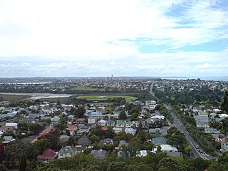
Devonport is a harbourside suburb of Auckland, New Zealand. It is located on the North Shore, at the southern end of a peninsula that runs southeast from near Lake Pupuke in Takapuna, forming the northern side of the Waitematā Harbour. East of Devonport lies North Head, the northern promontory guarding the mouth of the harbour.
The North Shore is part of the large urban area of Auckland, New Zealand, located to the north of the Waitematā Harbour. To the east, has the Hauraki Gulf, to the west, is West Auckland, to the south, has the Waitematā Harbour and Central Auckland, to the north has the Hibiscus Coast. From 1989 until 2010, North Shore City was an independent city within the Auckland Region, until it was incorporated into the Auckland Council.

The Kaipara District is located in the Northland Region in northern New Zealand.
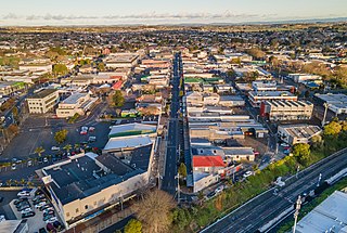
Pukekohe is a town in the Auckland Region of the North Island of New Zealand. Located at the southern edge of the Auckland Region, it is in South Auckland, between the southern shore of the Manukau Harbour and the mouth of the Waikato River. The hills of Pukekohe and nearby Bombay Hills form the natural southern limit of the Auckland region. Pukekohe is located within the political boundaries of the Auckland Council, following the abolition of the Franklin District Council on 1 November 2010.
Grant Gillon is a former New Zealand politician. He was a member of parliament between 1996 and 2002, representing the Alliance Party, has held a number of seats in local government. He previously served on the Devonport-Takapuna Local Board representing Shore Action.

Northcote is a suburb of Auckland in northern New Zealand. It is situated on the North Shore, on the northern shores of Waitematā Harbour, four km northwest of Auckland CBD. The suburb includes the peninsula of Northcote Point and the northern approaches to the Auckland Harbour Bridge. Northcote Central is to the north of Northcote.

Whenuapai is a suburb and aerodrome located in northwestern Auckland, in the North Island of New Zealand. It is located on the northwestern shore of the Waitematā Harbour, 15 kilometres to the northwest of Auckland's city centre. It is one of the landing points for the Southern Cross telecommunications Cables. The name is Māori for good land.

Māngere is a major suburb in South Auckland, New Zealand, located on mainly flat land on the northeastern shore of the Manukau Harbour, to the northwest of Manukau City Centre and 15 kilometres south of the Auckland city centre. It is the location of Auckland Airport, which lies close to the harbour's edge to the south of the suburb.

Birkenhead is a suburb of Auckland, in northern New Zealand. It is located on the North Shore of the Waitemata Harbour, four kilometres northwest of the Auckland CBD.

Takapuna is a suburb located on the North Shore of Auckland, New Zealand. The suburb is situated at the beginning of a south-east-facing peninsula forming the northern side of the Waitematā Harbour. While very small in terms of population, it was the seat of the North Shore City Council before amalgamation into Auckland Council in 2010 and contains substantial shopping and entertainment areas, acting as a CBD for the North Shore.

Glenfield is a suburb, part of the contiguous Auckland metropolitan area. It is located in the North Shore, north of the Waitemata Harbour, and Auckland is located in New Zealand.

Forrest Hill is a suburb located on the North Shore of Auckland, New Zealand.

Auckland is a large metropolitan city in the North Island of New Zealand. The most populous urban area in the country and the fifth largest city in Oceania, Auckland has an urban population of about 1,440,300. It is located in the greater Auckland Region—the area governed by Auckland Council—which includes outlying rural areas and the islands of the Hauraki Gulf, and which has a total population of 1,695,200. While Europeans continue to make up the plurality of Auckland's population, the city became multicultural and cosmopolitan in the late-20th century, with Asians accounting for 31% of the city's population in 2018. Auckland has the eighth-largest proportion of foreign born residents in the world, with 41% of its residents born overseas. With its large population of Pasifika New Zealanders, the city is also home to the biggest ethnic Polynesian population in the world. The Māori-language name for Auckland is Tāmaki Makaurau, meaning "Tāmaki desired by many", in reference to the desirability of its natural resources and geography.

Chris Darby is an Auckland Councillor for the North Shore Ward and the chair of the Planning Committee. He is focused on public transport, urban regeneration and environmental issues. He is a progressive independent who is not affiliated to any political party. He ran on his independent ticket 'Taking the Shore Forward' in the 2013, 2016 and 2019 elections, and was elected each time.
Richard Brian Hills is an Auckland Councillor who was elected at the 2016 Auckland elections. He is Auckland's youngest current councillor, the first openly gay Auckland Councillor and one of two Ngāpuhi iwi members. He has been an advocate for more investment in local youth and secured a youth centre in Glenfield.

North Shore Ward is an Auckland Council ward that elects two councillors and covers the Devonport-Takapuna and Kaipātiki Local Boards. The two councillors are currently Richard Hills and Chris Darby.

The Devonport-Takapuna Local Board covers from Castor Bay, and Sunnynook south to the end of the Devonport Peninsula; it is separated from the Kaipātiki board area by the Northern Motorway. This local board sits in the Auckland Council office buildings on The Strand in Takapuna. These were the North Shore City Council offices until the North Shore City Council was merged into Auckland Council in 2010. It is part of the North Shore Ward of Auckland Council, which also includes the Kaipātiki Local Board.

The Kaipātiki Local Board is one of the 21 local boards of Auckland Council, and is one of the two boards overseen by the council's North Shore Ward councillors. It covers Glenfield south to Northcote Point. Its eastern border is the Northern Motorway and its western border is the Waitematā Harbour. The board sits at the Citizen's Advice Bureau in Bentley Ave, Glenfield. AUT's Akoranga Campus is the only tertiary institution in the North Shore ward, and it is in the Kaipātiki board area.
Devonport-Takapuna is a local government area in Auckland, in New Zealand's Auckland Region, governed by the Devonport-Takapuna Local Board and Auckland Council. It currently aligns with the council's North Shore Ward.

