Demographics
Forrest Hill covers 2.90 km2 (1.12 sq mi) [2] and had an estimated population of 10,750 as of June 2024, [3] with a population density of 3,707 people per km2.
Historical population| Year | | |
|---|
| 2006 | 8,712 | — |
|---|
| 2013 | 9,474 | +1.21% |
|---|
| 2018 | 10,023 | +1.13% |
|---|
| 2023 | 10,053 | +0.06% |
|---|
| Source: [7] [8] |
Forrest Hill had a population of 10,053 in the 2023 New Zealand census, an increase of 30 people (0.3%) since the 2018 census, and an increase of 579 people (6.1%) since the 2013 census. There were 4,977 males, 5,040 females and 33 people of other genders in 3,162 dwellings. [9] 2.8% of people identified as LGBTIQ+. The median age was 36.8 years (compared with 38.1 years nationally). There were 1,818 people (18.1%) aged under 15 years, 2,160 (21.5%) aged 15 to 29, 4,800 (47.7%) aged 30 to 64, and 1,275 (12.7%) aged 65 or older. [8]
People could identify as more than one ethnicity. The results were 44.7% European (Pākehā); 5.1% Māori; 3.1% Pasifika; 50.0% Asian; 3.4% Middle Eastern, Latin American and African New Zealanders (MELAA); and 2.1% other, which includes people giving their ethnicity as "New Zealander". English was spoken by 89.5%, Māori language by 0.9%, Samoan by 0.4%, and other languages by 44.6%. No language could be spoken by 1.9% (e.g. too young to talk). New Zealand Sign Language was known by 0.2%. The percentage of people born overseas was 54.9, compared with 28.8% nationally.
Religious affiliations were 31.5% Christian, 2.5% Hindu, 2.8% Islam, 0.2% Māori religious beliefs, 2.2% Buddhist, 0.1% New Age, 0.2% Jewish, and 1.1% other religions. People who answered that they had no religion were 54.4%, and 5.1% of people did not answer the census question.
Of those at least 15 years old, 3,303 (40.1%) people had a bachelor's or higher degree, 3,111 (37.8%) had a post-high school certificate or diploma, and 1,815 (22.0%) people exclusively held high school qualifications. The median income was $44,100, compared with $41,500 nationally. 1,233 people (15.0%) earned over $100,000 compared to 12.1% nationally. The employment status of those at least 15 was that 4,452 (54.1%) people were employed full-time, 1,110 (13.5%) were part-time, and 237 (2.9%) were unemployed. [8]
Individual statistical areas| Name | Area
(km2) | Population | Density
(per km2) | Dwellings | Median age | Median
income |
|---|
| Forrest Hill North | 0.74 | 2,472 | 3,341 | 759 | 36.3 years | $42,800 [10] |
| Forrest Hill West | 1.24 | 4,053 | 3,269 | 1,221 | 37.0 years | $40,700 [11] |
| Forrest Hill East | 0.92 | 3,528 | 3,835 | 1,182 | 36.9 years | $49,500 [12] |
| New Zealand | | | | | 38.1 years | $41,500 |
|---|

Greater Wellington, also known as the Wellington Region, is a non-unitary region of New Zealand that occupies the southernmost part of the North Island. The region covers an area of 8,049 square kilometres (3,108 sq mi), and has a population of 550,600.

The South Wairarapa District is a district at the south-east tip of the North Island of New Zealand, governed by the South Wairarapa District Council. The district comprises the southernmost part of the Wairarapa, and is part of the Wellington Region.

The Thames-Coromandel District is a territorial authority district in the North Island of New Zealand, covering all the Coromandel Peninsula and extending south to Hikutaia.

Hauraki District is a territorial authority governed by the Hauraki District Council within the Waikato region of New Zealand. The seat of the council is at Paeroa.

Waikato District is a territorial authority of New Zealand, in the northern part of Waikato region, North Island. Waikato District is administered by the Waikato District Council, with headquarters in Ngāruawāhia.

Southland District is a New Zealand territorial authority district that covers most of the southern end of the South Island as well as Stewart Island.

Central Otago District is local government district in New Zealand. It is administered by the Central Otago District Council, and it is in the Otago region, the top tier of local government in New Zealand. The major towns in the district are Alexandra, Cromwell, Roxburgh, Clyde and Ranfurly. The district covers 9,968 km2 (3,849 sq mi), making it the fourth-largest district in New Zealand by area, and is home to 26,500 people as of June 2024.

Westland District is a territorial authority district on the West Coast of New Zealand's South Island. It is administered by the Westland District Council. The district's population is 9,430.

Clutha District is a local government district of southern New Zealand, with its headquarters in the Otago town of Balclutha. Clutha District has a land area of 6,334.47 km2 (2,445.75 sq mi) and an estimated population of 19,300 as of June 2024. Clutha District occupies the majority of the geographical area known as South Otago.
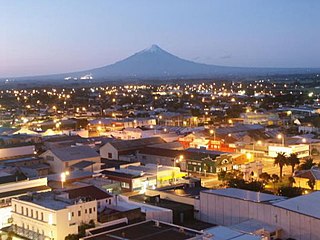
South Taranaki is a territorial authority on the west coast of New Zealand's North Island that contains the towns of Hāwera, Manaia, Ōpunake, Patea, Eltham, and Waverley. The District has a land area of 3,575.46 km2 and a population of 30,400. It is part of the greater Taranaki Region.

Mackenzie District is a local government district on New Zealand's South Island, administered by the Mackenzie District Council. It is part of the larger Canterbury Region. The region takes its name from the Mackenzie Basin, an elliptical intermontane basin which covers much of inland Canterbury.
West Harbour is a suburb of Auckland, located to the west of the Auckland isthmus and CBD. It is named for its location on the western side of the Waitematā Harbour. West Harbour is under the governance of Auckland Council after the amalgamation of district councils in 2010.

Massey is a northern suburb in West Auckland, New Zealand. It was formerly a northern suburb of Waitakere City, which existed from 1989 to 2010 before the city was amalgamated into Auckland Council. The suburb was named after former Prime Minister of New Zealand William Massey. Massey is a relatively large suburb and can be divided into three reasonably distinctive areas, Massey West, Massey East and Massey North. Parts of Massey East are also known as 'Royal Heights', which is home to the Royal Heights shopping centre.

Whangarei District is a territorial authority district in the Northland Region of New Zealand that is governed by the Whangarei District Council. The district is made up in area largely by rural land, and includes a fifth of the Northland Region. It extends southwards to the southern end of Bream Bay, northwards to Whangaruru and almost to the Bay of Islands, and westwards up the Mangakahia River valley past Pakotai and almost to Waipoua Forest. It includes the Hen and Chicken Islands and the Poor Knights Islands.
Stanmore Bay is a suburb and beach located on the Whangaparaoa Peninsula, in the Auckland Region of New Zealand. The beach is on the northern side of the peninsula.

Bayview is a suburb of Auckland in New Zealand. The area was included into the North Shore ward in 2010, one of the new thirteen administrative areas of the new Auckland Council.

Waimate District is a territorial authority district located in the Canterbury Region of the South Island of New Zealand. The main town is Waimate, while there are many smaller rural communities dispersed throughout the area. Its boundary to the south is the Waitaki River, to the west Lake Benmore and to the north-east the Pareora River.
Rānui is a suburb of West Auckland, New Zealand, which is under the local governance of Auckland Council. The area is densely populated but close to the western fringe of the Auckland urban area.
Tōtara Vale is a suburb located on the North Shore of Auckland, New Zealand. It is under the local governance of Auckland Council.

Royal Heights is a suburb in West Auckland, under the local governance of Auckland Council. Moire Park is a large park in Royal Heights, which has both sports grounds and areas of bush with walking tracks. The Manutewhau Walkway in Moire Park follows the Manutewhau Stream.

