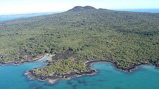
Rangitoto Island is a volcanic island in the Hauraki Gulf near Auckland, New Zealand. The 5.5 km (3.4 mi) wide island is a symmetrical shield volcano cone capped by central scoria cones, reaching a height of 260 m (850 ft). Rangitoto is the youngest and largest of the approximately 50 volcanoes of the Auckland volcanic field, having erupted in two phases about 1450 CE and 1500 CE and covering an area of 2,311 ha. It is separated from the mainland of Auckland's North Shore by the Rangitoto Channel. Since World War II, it has been linked by a causeway to the much older, non-volcanic Motutapu Island.

Mount Jefferson is a stratovolcano in the Cascade Volcanic Arc, part of the Cascade Range in the U.S. state of Oregon. The second highest mountain in Oregon, it is situated within Linn County, Jefferson County, and Marion County and forms part of the Mount Jefferson Wilderness. Due to the ruggedness of its surroundings, the mountain is one of the hardest volcanoes to reach in the Cascades. It is also a popular tourist destination despite its remoteness, with recreational activities including hiking, backpacking, mountaineering, and photography. Vegetation at Mount Jefferson is dominated by Douglas fir, silver fir, mountain hemlock, ponderosa pine, lodgepole pine, and several cedar species. Carnivores, insectivores, bats, rodents, deer, birds, and various other species inhabit the area.

A xenolith is a rock fragment that becomes enveloped in a larger rock during the latter's development and solidification. In geology, the term xenolith is almost exclusively used to describe inclusions in igneous rock entrained during magma ascent, emplacement and eruption. Xenoliths may be engulfed along the margins of a magma chamber, torn loose from the walls of an erupting lava conduit or explosive diatreme or picked up along the base of a flowing body of lava on the Earth's surface. A xenocryst is an individual foreign crystal included within an igneous body. Examples of xenocrysts are quartz crystals in a silica-deficient lava and diamonds within kimberlite diatremes. Xenoliths can be non-uniform within individual locations, even in areas which are spatially limited, e.g. rhyolite-dominated lava of Niijima volcano (Japan) contains two types of gabbroic xenoliths which are of different origin - they were formed in different temperature and pressure conditions.
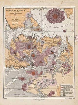
The Auckland volcanic field is an area of monogenetic volcanoes covered by much of the metropolitan area of Auckland, New Zealand's largest city, located in the North Island. The approximately 53 volcanoes in the field have produced a diverse array of maars, tuff rings, scoria cones, and lava flows. With the exception of Rangitoto, no volcano has erupted more than once, but the other eruptions lasted for various periods ranging from a few weeks to several years. Rangitoto erupted several times and recently twice; in an eruption that occurred about 600 years ago, followed by a second eruption approximately 50 years later. The field is fuelled entirely by basaltic magma, unlike the explosive subduction-driven volcanism in the central North Island, such as at Mount Ruapehu and Lake Taupō.

The Horeke basalts is a disused formation that contained Miocene-Pliocene basalt lava flows that covered a large area in central Northland Region of New Zealand, and in places forms a high plateau around Okaihau.

The fifteen volcanoes that make up the eight principal islands of Hawaii are the youngest in a chain of more than 129 volcanoes that stretch 5,800 kilometers (3,600 mi) across the North Pacific Ocean, called the Hawaiian–Emperor seamount chain. Hawaiʻi's volcanoes rise an average of 4,600 meters (15,000 ft) to reach sea level from their base. The largest, Mauna Loa, is 4,169 meters (13,678 ft) high. As shield volcanoes, they are built by accumulated lava flows, growing a few meters or feet at a time to form a broad and gently sloping shape.

Lake Pupuke is a heart-shaped freshwater lake occupying a volcanic crater between the suburbs of Takapuna and Milford on the North Shore of Auckland, New Zealand. The heart shape is a result of its formation by the linking of two circular craters – a larger one forming most of the lake and a smaller one forming the arm in the northeast. Separated from the sea by less than 200 m at one point, it has a circumference of about 4.5 km and reaches 57 m in depth. It is popular for recreational activities and the lakefront property around it.

Takapuna is a suburb located on the North Shore of Auckland, New Zealand. The suburb is situated at the beginning of a south-east-facing peninsula forming the northern side of the Waitematā Harbour. While very small in terms of population, it was the seat of the North Shore City Council before amalgamation into Auckland Council in 2010 and contains substantial shopping and entertainment areas, acting as a CBD for the North Shore.

Tweed Volcano is a partially eroded Early Miocene shield volcano located in northeastern New South Wales, which formed when this region of Australia passed over the East Australia hotspot around 23 million years ago. Mount Warning, Lamington Plateau and the Border Ranges between New South Wales and Queensland are among the remnants of this volcano that was originally over 100 kilometres (62 mi) in diameter and nearly twice the height of Mount Warning today, at 1,156 metres (3,793 ft). Despite its size, Tweed Volcano was not a supervolcano; other shield volcanoes—such as in the Hawaiian Islands—are much larger. In the 23 million years since the volcano was active, erosion has been extensive, forming a large erosion caldera around the volcanic plug of Mount Warning. Its erosion caldera is the largest in the Southern Hemisphere.
Te Kohuroa / Mathesons Bay is a small beach in the Rodney district of the Auckland Region of New Zealand. It is 21 kilometres north-east of Warkworth, near the small community of Leigh. It comprises mainly holiday homes, with a small number of permanent residents.

Achilles Point is a rocky point on the headland at the eastern end of the small sandy beach named Ladies Bay, Auckland, New Zealand. The name 'Te Pane o Horoiwi' can also sometimes refer to the whole headland between St Heliers and Tamaki River estuary. Achilles Point is named after a ship called HMNZS Achilles (70) which defeated the German pocket battleship Admiral Graf Spee in 1939. The headland, from the point round to the Tamaki heads, was previously known as Te Pane o Horoiwi, named after Horoiwi who arrived in New Zealand on the Tainui canoe (waka).

Pilot Knob is the eroded core of an extinct volcano located 8 miles (13 km) south of central Austin, Texas, near Austin-Bergstrom International Airport and McKinney Falls State Park.

The Auckland Region of New Zealand is built on a basement of greywacke rocks that form many of the islands in the Hauraki Gulf, the Hunua Ranges, and land south of Port Waikato. The Waitākere Ranges in the west are the remains of a large andesitic volcano, and Great Barrier Island was formed by the northern end of the Coromandel Volcanic Zone. The Auckland isthmus and North Shore are composed of Waitemata sandstone and mudstone, and portions of the Northland Allochthon extend as far south as Albany. Little Barrier Island was formed by a relatively isolated andesitic volcano, active around 1 to 3 million years ago.

Crater Hill is one of the volcanoes of the Auckland volcanic field, in New Zealand. It consists of an explosion crater about 600 metres (2,000 ft) wide, partly filled with water. The hill, alongside Māngere Lagoon, Waitomokia, Kohuora, Pukaki Lagoon and Robertson Hill, is one of the volcanic features collectively referred to as Nga Tapuwae a Mataoho, referring to the deity in Tāmaki Māori myths who was involved in their creation.

Ōrākei Basin is a tidal basin and one of the extinct volcanoes in the Auckland volcanic field in the North Island of New Zealand. It has an explosion crater around 700 m (2,300 ft) wide, with a surrounding tuff ring. The present basin is slightly larger than the original maar crater. Sediments in the basin provided the first high-resolution palaeo-environmental reconstruction for northern New Zealand of the last 130,000 years. The basin supports recreational water sports activities for the local population.
Grafton Volcano is a buried volcano in New Zealand's Auckland volcanic field that underlies much of the Auckland suburb of Grafton. First recognised in 2010, it includes the Outhwaite Park scoria cone that was first mapped by Hochstetter (1864) and inferred by later geologists to be a late phase vent of adjacent Pukekawa Volcano. Borehole drilling and building excavations in the Grafton-Auckland Domain area during the 1990s and 2000s provided new subsurface geological information that allowed geologists to recognise the buried Grafton Volcano.

Wairere Boulders is a privately-owned nature reserve and tourist attraction at Horeke in the south Hokianga region of Northland, New Zealand. The property contains geologically rare rock formations. Visitors to the property can walk around the various trails, kayak down the boulder river and stay at the campsite.

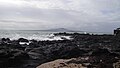
Lion Rock is a rocky headland located on Piha Beach in the Waitākere Ranges area of the Auckland Region, New Zealand.
The Waitākere volcano, also known as the Manukau volcano, was a Miocene era volcano that formed off the west coast of the modern Auckland Region of New Zealand's North Island. Erupting intermittently between 23 million and 15 million years ago, the volcano was at one point one of the tallest mountains in New Zealand. The volcano alternated between periods as a seamount and as a volcanic island, before tectonic forces raised the volcano up from the seafloor 17 million years ago. Volcanism at the site ceased 15 million years ago and the cone has mostly eroded, however the modern Waitākere Ranges are formed from the remnants of the volcano's eastern slopes. A number of visible volcanic sites associated with the Waitākere volcano remain around Auckland, including Pukematekeo, Karekare and Lion Rock.

The Almorah Rock Forest is a lava rock forest located on the northeastern slope of Maungawhau / Mount Eden, in Auckland, New Zealand. It is one of the few remaining lava rock forests in the region.