Crucorney

Last updated

Road to Cwmyoy and Llanthony near the Skirrid Inn, Llanvihangel Crucorney Road to Cwmyoy and Llanthony from Llanvihangel Crucorney - 3846100 - geograph.org.uk.jpg
Road to Cwmyoy and Llanthony near the Skirrid Inn, Llanvihangel Crucorney

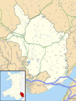
Crucorney Welsh : Crucornau is a community in the county of Monmouthshire, Wales. It is the northernmost community in the county and covers the villages of Llanvihangel Crucorney, Pandy, Cwmyoy and Llanthony amongst others. The Vale of Ewyas comprises much of the northern part of the community, with the River Honddu running through Llanthony and Llanvihangel Crucorney, before turning northeast passing Pandy towards the River Monnow. The 2011 population was 1,201. [1]

Contents

Notable landmarks include Llanthony Priory, a Grade I listed former Augustinian priory at Llanthony. [2] Offa's Dyke Path runs along the border between Crucorney and the English county of Herefordshire. The community also has a voluntary group, The Crucorney Environmental Group, which oversees environmental and sustainability issues, including sustainable development, recycling and litter picking. [3]
Governance

The community elects a community council of eleven councillors. [4] The council meets monthly on the third Tuesday of each month. [5]

Crucorney is also the name of the electoral ward for Monmouthshire County Council. The ward also covers the neighbouring Grosmont community and elects one county councillor. [6]

Related Research Articles

Caldicot, Monmouthshire Human settlement in Wales

Caldicot is a market town and community in Monmouthshire, Wales. The town is located between Chepstow and the city of Newport. The site adjoins the Caldicot Levels, on the north side of the Severn Estuary. The population of the town is around 11,000. It has a large school, Caldicot School, and is known for its medieval castle. The built-up area includes Portskewett. Caldicot had a population of 9,604 in 2011.

Trowbridge, Cardiff Community/Electoral ward in Wales

Trowbridge is a district, community and coterminous electoral ward on the eastern edge of the city of Cardiff, capital of Wales.

Llanthony Priory Grade I listed priory in the United Kingdom

Llanthony Priory is a partly ruined former Augustinian priory in the secluded Vale of Ewyas, a steep-sided once-glaciated valley within the Black Mountains area of the Brecon Beacons National Park in Monmouthshire, south east Wales. It lies seven miles north of Abergavenny on an old road to Hay-on-Wye at Llanthony. The priory ruins lie to the west of the prominent Hatterrall Ridge, a limb of the Black mountains. The main ruins are under the care of Cadw and entrance is free.

Vale of Ewyas

The Vale of Ewyas is the steep-sided and secluded valley of the River Honddu, in the Black Mountains of Wales and within the Brecon Beacons National Park. As well as its outstanding beauty, it is known for the ruins of Llanthony Priory, and for several noteworthy churches such as those at Capel-y-ffin and Cwmyoy. It is sometimes referred to as the "Llanthony Valley" as Llanthony is the village situated at the valley centre.

Llanvihangel Crucorney Human settlement in Wales

Llanvihangel Crucorney is a small village in the community (parish) of Crucorney, Monmouthshire, Wales. It is located 5 miles (8.0 km) north of Abergavenny and 18 miles (29 km) south-west of Hereford, England on the A465 road.

Llanthony Human settlement in Wales

Llanthony is a village in the community of Crucorney on the northern edge of Monmouthshire, South East Wales, United Kingdom.

River Honddu (Monmouthshire)

The River Honddu is a river in the Black Mountains within the Brecon Beacons National Park, southeast Wales. Early recorded versions of the name are of the form Hothenei and hodni which are believed to contain the adjective 'hawdd' meaning for example, pleasant or easy. Later forms such as Honddye have undergone metathesis whereby -ddn- became -ndd-.

Abbey Hotel, Llanthony Priory

Abbey Hotel is a Grade I listed building incorporating a hotel and country inn in Llanthony, Monmouthshire, Wales.

John Arnold, widely known as John Arnold of Monmouthshire, was a Welsh Protestant politician and Whig MP. He was one of the most prominent people in Monmouthshire in the late 17th century. A stark anti-Catholic, he was a notable figure during the Popish plot and the suppression of Catholicism in the country. Arnold represented the constituencies around Monmouth and Southwark in Parliament in the 1680s and 1690s. His strong anti-Catholic beliefs and insurgences against Catholic priests made him an unpopular and controversial figure amongst his peers and in his native Monmouthshire. In his later years his behaviour became increasingly eccentric, and he was widely believed to have faked an attempt on his own life. Amongst his associates were Titus Oates and Anthony Ashley Cooper, 1st Earl of Shaftesbury.

Trellech United Community/Electoral ward in Wales

Trellech United is a community and electoral ward in the county of Monmouthshire, Wales. It lies south of the county town of Monmouth next to the Wales-England border.

Magor with Undy is a community on the coast of the Severn Estuary in Monmouthshire, Wales. It includes the villages of Magor and Undy.

Llwyn-celyn Farmhouse, Llanvihangel Crucorney

Llwyn-celyn Farmhouse, Llanvihangel Crucorney, Monmouthshire is a farmhouse of late medieval origins. It is a Grade I listed building.

2017 Monmouthshire County Council election Election to all seats of the non-metropolitan county council of Monmouthshire in May 2012.

An election to Monmouthshire County Council took place on 4 May 2017 as part of the 2017 Welsh local elections. 43 councillors were to be elected from both single-member and dual-member electoral divisions by first-past-the-post for a five-year term of office. The elections were preceded by the 2012 elections and followed by the 2022 elections.

Haverfordwest Priory (electoral ward) Electoral ward in Wales

Haverfordwest Priory is the name of an electoral ward in Pembrokeshire, Wales. It covers the southern edge of the town of Haverfordwest, mostly west of the river but including Haverfordwest railway station at its eastern extreme, the Haverfordwest Priory from which it takes its name and the residential areas bounded by Freeman's Way and surrounding the Pembrokeshire College campus. The ward elects a councillor to Pembrokeshire County Council.

Priory is an electoral ward in Abergavenny, Monmouthshire. The ward elects councillors to Abergavenny Town Council and Monmouthshire County Council.

Larkfield is an electoral ward in Chepstow, Monmouthshire. The ward elects councillors to Chepstow Town Council and Monmouthshire County Council.

Castle is an electoral ward in Abergavenny, Monmouthshire. The ward elects councillors to Abergavenny Town Council and Monmouthshire County Council.

Caldicot Castle is an electoral ward in the town of Caldicot, Monmouthshire, Wales. The ward elects councillors to Caldicot Town Council and Monmouthshire County Council.

Severn is the name of an electoral ward in the town of Caldicot, Monmouthshire, Wales. The ward elects councillors to Caldicot Town Council and Monmouthshire County Council.

St Mary's is the name of an electoral ward in the town of Chepstow, Monmouthshire, Wales. The ward elects councillors to Chepstow Town Council and Monmouthshire County Council.

References

  1. "Custom report - Nomis - Official Labour Market Statistics".
  2. Llanthony Priory, Crucorney, British Listed Buildings. Retrieved 10 April 2016.
  3. Crucorney Environmental Group, Crucorney Community Portal. Retrieved 10 April 2016.
  4. Community Councillors, Crucorney Community Portal. Retrieved 10 April 2016.
  5. Community Councils and Town Councils Archived 2015-04-14 at the Wayback Machine (pdf), Monmouthshire County Council. Retrieved 10 April 2016.
  6. The County of Monmouthshire (Electoral Changes) Order 2002. legislation.gov.uk. Statutory Instruments. 6 December 2002. Retrieved 11 January 2019.

Coordinates: 51°54′31″N3°01′43″W / 51.9086°N 3.0285°W / 51.9086; -3.0285