Currawong Bush Park

Last updated

Currawong Bush Park
Millers Pond Currawong Bush Park.JPG
Millers Pond in Currawong Bush Park
Currawong Bush Park
TypePublic Park
Location Melbourne
Coordinates 37°45′40″S145°11′02″E / 37.7612°S 145.1839°E / -37.7612; 145.1839 Coordinates: 37°45′40″S145°11′02″E / 37.7612°S 145.1839°E / -37.7612; 145.1839
Area59 hectares
Opened1970's
Operated by City of Manningham
Visitors750 per month approx.
StatusOpen
PathsUnsealed bush paths
TerrainRemnant Riparian Bushland
Water Mullum Mullum Creek, Millers Pond, Billy Baxter Wetlands, Go-Betweens Gully, Amersham Gully
Vegetation Australian Native
Landmarks Mullum Mullum Creek, Scar Trees
FacilitiesToilets, Barbecues, Picnic areas, Conference room, Education centre, Wildlife sanctuary
Aerial panorama of Currawong Bush Park facing west to Melbourne city Aerial panorama of Currawong Bush Park facing Melbourne city.jpg
Aerial panorama of Currawong Bush Park facing west to Melbourne city

Currawong Bush Park is a nature park located in the outer eastern Melbourne suburbs of Doncaster East, Warrandyte and Donvale, along Mullum Creek. [1] It covers 59 hectares of remnant bushland and contains archaeological sites significant to the Traditional Owners of the area, the Wurundjeri people of the Kulin nation.

Contents

History

Aerial panorama of Currawong Bush Park facing east to the Dandenong Ranges Aerial panorama of Currawong Bush Park facing east to the Dandenong Ranges.jpg
Aerial panorama of Currawong Bush Park facing east to the Dandenong Ranges

An archaeological survey of Aboriginal sites within the City of Manningham by Isabel Ellender in 1991, [2] discovered evidence of the presence of the Wurundjeri people in the park, in the form of four scarred trees. [ citation needed ] An Aboriginal stone artefact was also found along Mullum Mullum Creek. The Wurundjeri were part of the Kulin nation, comprising the main tribes living within about a 150 km radius of Melbourne. The Wurundjeri are of the Woiwurrung tribe, one of five Kulin tribes, each of whom had their land and language.

More recent history shows the building, housing, the Ranger's Residence, Park Office and Conference Room as a building of State historical significance. It is a notable example of the design work of Victorian architect Geoffrey Trewenack. It has sometimes mistakenly been attributed to the Victorian architect Kevin Borland. The house was built by Robin and Bunty Elder, in 1959. They resided there until approximately 1969 when the property was acquired as a public park.

Currently, the park has no on-site manager or ranger. Previously, a full-time ranger was employed by the City of Manningham through an environmental group until funding was cut around 2004. According to the Currawong Bush Park management plan in 2003, $1–2 million would be enough to upgrade facilities and deal with threats to the park's ecology. Three staffs are required to operate and manage the park properly. [3]

Geography

Regenerative planting near the education centre and camping site Currawong regenerative planting.JPG
Regenerative planting near the education centre and camping site

The park is 59-hectares of bushland in the Yarra Valley on the eastern bank of the Mullum Mullum Creek, from the creek itself along the flat banks and up the hillside. The hillside is faulted by two gullies that flow into the Mullum Mullum Creek; Go-betweens Gully and Amersham Gully. The Mullum Mullum Creek Linear Park sits on the opposite bank of Mullum Mullum Creek to the west. [4]

Watercourses

Waterbodies

Ecology

The heritage listed Conference Centre building Currawong bush park conference centre.JPG
The heritage listed Conference Centre building

Native species of flora and fauna can be found within the park, including many species of eucalypts such as the Manna Gum and kangaroos such as the Eastern Grey.

Threats to Ecology

Being surrounded by low-density residential development, some of the most urgent problems the park faces are from the introduced species such as rabbits, foxes, stray dogs, and cats, occupying the park. Stray dogs mutilate Eastern Grey kangaroos and any young they may be carrying, and rabbits dig furrows in the soil and entice foxes into the park who compete with stray dogs for territory. [ citation needed ] Stray cats hunt native bird life and possums. Various weeds from neighbouring properties flow down watercourses into the gullies.[ citation needed ]

Threats from humans include disturbance of plant and animal life from motorbikes and bicycles, and light pollution from the neighbouring hockey field in the southern area of the park. The combined effect of the light pollution, traffic noise and pollution from Reynolds Road drives wildlife away from the southern slopes and into other areas of the park where they compete with other species for already limited resources. [5]

Visitor Experience

There are formed walking trails and places of interest to draw visitors to the park. [6] Currawong Bush Park Walks are a series of eight walks, each focusing on different aspects of the reserve. All of these walks start and finish within the park. Downloading the audio guides [7] will enhance your Currawong experience.

Regulations

The entire park is off-limits to dogs. Motorized transport including motorbikes, scooters, and trail bikes are strictly limited to the roadway and carparks. Cyclists may ride on fire access tracks, but must dismount before entering smaller, unsealed walking tracks. The park is particularly susceptible to bushfires and, being so close to residential areas, the fire danger in the area is immediate. Fire is only to be used in the campfire site near the education centre, where there are electric barbecues for cooking. There is no camping allowed in the park. [8]

Related Research Articles

<span class="mw-page-title-main">Wurundjeri</span> Aboriginal Australian people who inhabited the Melbourne area before colonisation

The Wurundjeripeople are an Australian Aboriginal people of the Woiwurrung language group, in the Kulin nation. They are the traditional owners of the Yarra River Valley, covering much of the present location of Melbourne. They continue to live in this area and throughout Australia. They were called the Yarra tribe by early European colonists.

<span class="mw-page-title-main">City of Manningham</span> Local government area in Victoria, Australia

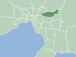
The City of Manningham is a local government area in Victoria, Australia in the north-eastern suburbs of Melbourne and is divided into 12 suburbs, with the largest being Doncaster and Doncaster East. It comprises an area of 113 square kilometres and had a population of 125,508 in June 2018.

<span class="mw-page-title-main">Maribyrnong River</span> River in Melbourne, Victoria, Australia

The Maribyrnong River is a perennial river of the Port Phillip catchment, located in the north–western suburbs of Melbourne, in the Australian state of Victoria.

<span class="mw-page-title-main">Warrandyte, Victoria</span> Suburb of Melbourne, Victoria, Australia

Warrandyte is a suburb of Melbourne, Victoria, Australia, 24 km north-east of Melbourne's Central Business District, located within the City of Manningham local government area. Warrandyte recorded a population of 5,541 at the 2021 census.

<span class="mw-page-title-main">Templestowe, Victoria</span> Suburb of Melbourne, Victoria, Australia

Templestowe is a suburb of Melbourne, Victoria, Australia, 16 km north-east of Melbourne's Central Business District, located within the City of Manningham local government area. Templestowe recorded a population of 16,966 at the 2021 census.

<span class="mw-page-title-main">Kulin nation</span> Indigenous Australian ethnic group

The Kulin nation is an alliance of five Aboriginal nations in south central Victoria, Australia. Their collective territory extends around Port Phillip and Western Port, up into the Great Dividing Range and the Loddon and Goulburn River valleys.

<span class="mw-page-title-main">Doncaster East, Victoria</span> Suburb of Melbourne, Victoria, Australia

Doncaster East is a suburb of Melbourne, Victoria, Australia, 20 km east of Melbourne's Central Business District, located within the City of Manningham local government area. Doncaster East recorded a population of 30,926 at the 2021 census.

<span class="mw-page-title-main">Merri Creek</span> River in Victoria, Australia

The Merri Creek is a waterway in southern parts of Victoria, Australia, which flows through the northern suburbs of Northcote. It begins near Wallan north of Melbourne and flows south for 70 km until it joins the Yarra River at Dights Falls. The area where the creek meets the river was traditionally the location for large gatherings of the Wurundjeri people and is suspected to have been the location for one of the earliest land treaties in Australia between Indigenous Australians and European settlers.

<span class="mw-page-title-main">Blackburn Lake Sanctuary</span>

Blackburn Lake Sanctuary is an example of regenerated and remnant bushland in suburban Melbourne, Australia. It is located in the suburb of Blackburn. It is the most significant of the many parks in the City of Whitehorse, featuring areas of regenerated bushland and various walking tracks.

The Boonwurrung people are an Aboriginal people of the Kulin nation, who are the traditional owners of the land from the Werribee River to Wilsons Promontory in the Australian state of Victoria. Their territory includes part of what is now the city and suburbs of Melbourne. They were called the Western Port or Port Philip tribe by the early settlers, and were in alliance with other tribes in the Kulin nation, having particularly strong ties to the Wurundjeri people.

<span class="mw-page-title-main">Mullum Mullum Creek</span> River in Victoria, Australia

Mullum Mullum Creek is a creek in the outer eastern suburbs of Melbourne, Victoria, Australia. It is the main watercourse of the Mullum Mullum Valley, a tributary of the Yarra River and Yarra Valley. For tens of thousands of years it was used as a food and tool source sustainably by the Wurundjeri people, Indigenous Australians of the Kulin nation, who spoke variations of the Woiwurrung language group.

<span class="mw-page-title-main">Taungurung</span>

The Taungurung people, also spelt Daung Wurrung, are an Aboriginal people who are one of the Kulin nations in present-day Victoria, Australia. They consist of nine clans whose traditional language is the Taungurung language.
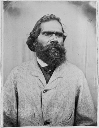
<span class="mw-page-title-main">Simon Wonga</span>

Simon Wonga (1824–1874), ngurungaeta and son of Billibellary, was an elder of the Wurundjeri people, who lived in the Melbourne area of Australia before European settlement. He was resolute that his people would survive the "onslaught" of white men.

<span class="mw-page-title-main">Gardiners Creek</span> River in Victoria, Australia

Gardiners Creek, originally known as Kooyongkoot Creek, is an urban stream in the eastern suburbs of Melbourne, and part of the Yarra River catchment.

<span class="mw-page-title-main">Ruffey Lake Park</span> Park in Melbourne, Victoria, Australia

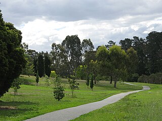
Ruffey Lake Park is a park in the City of Manningham, Melbourne, Victoria, Australia. It is situated around Ruffey Lake in a portion of a valley through which the Ruffey Creek runs, forming the border between Doncaster and Templestowe. It has three main entrances, Victoria St, The Boulevard and King St. Despite being the second largest park in Manningham, second to Westerfolds Park, it is the biggest urban park managed by the City of Manningham. It is approximately 68 hectares in size. Formerly orchards, the park has a diverse ecology; this includes a riparian strip of native bushland around the creek, areas of pine trees planted by early settlers and pockets of fruit trees remaining from past orchards.

<span class="mw-page-title-main">Mullum Mullum Creek Linear Park</span>

The Mullum Mullum Creek Linear Park is located east of Melbourne, Australia in the suburbs of Doncaster East and Donvale. It stretches for roughly 9 km along the western banks of the Mullum Mullum Creek between Heidelberg-Warrandyte Road and The Eastlink Trail. Facilities include sealed pathways, barbecues and shelters. Other features include, bush walking tracks, trails and equestrian trails. Throughout much of the 1990s, extensive regenerative planting was conducted throughout the entire length of the park; this has restored much of the native riparian bushland within the park, most prominently the Mullum Mullum Wetlands.

<span class="mw-page-title-main">Yarran Dheran</span>

Yarran Dheran Nature Reserve forms part of the Mullum Mullum Valley and is an important riparian bushland park, located in the outer eastern suburbs of Melbourne on the border of Donvale, on the banks of the Mullum Mullum Creek. The Reserve comprises 7.2 hectares and hosts a mix of remnant and regenerated bushland, and many native species of wildlife, particularly birds, of which some 85 species may be seen over time. The Mullum Mullum Creek Trail runs through the Reserve and there are many unsealed bush tracks through the native bushland. There is an Information Centre in the Reserve which is open on Sunday afternoons from 2.00 pm – 4.00 pm subject to volunteer availability. The Reserve includes a series of ponds that feed a cascade to the creek during wet spells. There are toilets and mown areas for picnics and seating. Yarran Dheran is a Dogs on Lead Reserve.

Billibellary was a song maker and influential ngurungaeta of the Wurundjeri-willam clan during the early years of European settlement of Melbourne. He was known by various names including Billi-billeri, Billibellary, Jika Jika, Jacky Jacky and Jaga Jaga. He was an astute and diplomatic leader, described as powerfully built with an influence and reputation that extended well beyond his clan.

A tanderrum is an Aboriginal Australian ceremony enacted by the nations of the Kulin people and other Aboriginal Victorian nations allowing safe passage and temporary access and use of land and resources by foreign people. It was a diplomatic rite involving the landholder's hospitality and a ritual exchange of gifts, sometimes referred to as "Freedom of the Bush".

<span class="mw-page-title-main">Woiwurrung</span>

The Woiwurrung, also spelt Woi-wurrung, Woi Wurrung, Woiwurrong, Woiworung, Wuywurung, are an Aboriginal Australian people of the Woiwurrung language group, in the Kulin alliance.

References

  1. "Currawong Bush Park | Manningham City Council". www.manningham.vic.gov.au. Retrieved 26 October 2022.
  2. Ellender, Isabel (1991). The Plenty Valley corridor: an archaeological survey of aboriginal sites. ISBN   9780730622642.
  3. Currawong Bush Park Management Plan, November 2003
  4. Melway Edition 36, 2009
  5. Currawong Bush Park Management Plan, November 2003
  6. "Currawong Bush Park Trails | Manningham City Council". www.manningham.vic.gov.au. Retrieved 24 January 2023.
  7. "Currawong Bush Park Trails maps and audio guides | Manningham City Council". www.manningham.vic.gov.au. Retrieved 24 January 2023.
  8. Melway Edition 36, 2009