The 1999–2000 Australian region cyclone season was a slightly above average tropical cyclone season. It ran from 1 November 1999 to 30 April 2000. The regional tropical cyclone operational plan also defines a "tropical cyclone year" separately from a "tropical cyclone season", with the "tropical cyclone year" for this season lasting from 1 July 1999 to 30 June 2000.

The 1997–98 Australian region cyclone season was a slightly below average tropical cyclone season. It ran from 1 November 1997 to 30 April 1998. The regional tropical cyclone operational plan also defines a tropical cyclone year separately from a tropical cyclone season, and the "tropical cyclone year" ran from 1 July 1997 to 30 June 1998.

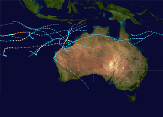
The 2005–06 Australian region cyclone season was an above average tropical cyclone season. It began on 1 November 2005 and ended on 30 April 2006. The regional tropical cyclone operational plan also defines a tropical cyclone year separately from a tropical cyclone season, which runs from 1 July 2005 to 30 June 2006.
The 2004–05 Australian region cyclone season was a slightly below average tropical cyclone season. It began on 1 November 2004 and ended on 30 April 2005. The regional tropical cyclone operational plan also defines a tropical cyclone year separately from a tropical cyclone season, which runs from 1 July 2004 to 30 June 2005.

The 2002–03 Australian region cyclone season included Cyclone Inigo, which tied with Cyclone Gwenda in 1999 as the most intense tropical cyclone on record in the Australian basin. It began on 1 November 2002 and ended on 30 April 2003. The regional tropical cyclone operational plan also defines a tropical cyclone year separately from a tropical cyclone season, which runs from 1 July 2002 to 30 June 2003. These dates conventionally delimit the period of each year when most tropical cyclones form in the Australian region, which is defined as in the southern hemisphere between 90°E and 180°E. The season's ten tropical depressions existed within these dates, with the first, designated as Tropical Cyclone 07S, entering the basin on 27 December 2002. The last system, Cyclone Epi, dissipated on 6 June 2003. Tropical cyclones in this area were monitored by four Tropical Cyclone Warning Centres (TCWCs): the Australian Bureau of Meteorology (BOM) in Perth, Darwin, and Brisbane and one in Port Moresby, Papua New Guinea.

The 2000–01 Australian region cyclone season was a below average tropical cyclone season. It began on 1 November 2000 and ended on 30 April 2001. The regional tropical cyclone operational plan also defines a tropical cyclone year separately from a tropical cyclone season, which runs from 1 July 2000 to 30 June 2001.
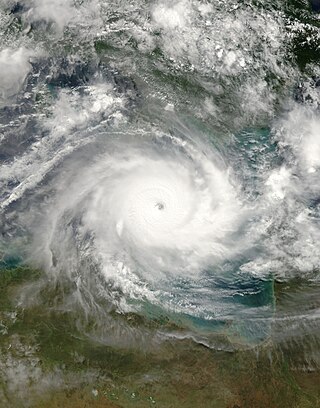
Severe Tropical Cyclone Monica was the most intense tropical cyclone, in terms of maximum sustained winds, on record to impact Australia. The 17th and final storm of the 2005–06 Australian region cyclone season, Monica originated from an area of low pressure off the coast of Papua New Guinea on 16 April 2006. The storm quickly developed into a Category 1 cyclone the next day, at which time it was given the name Monica. Travelling towards the west, the storm intensified into a severe tropical cyclone before making landfall in Far North Queensland, near Lockhart River, on 19 April 2006. After moving over land, convection associated with the storm quickly became disorganised.

Severe Tropical Cyclone Rona and Severe Tropical Cyclone Frank were a pair of tropical cyclones that affected Queensland and New Caledonia during the 1998–99 Australian region cyclone season and the 1998–99 South Pacific cyclone season. Rona originated from a low that developed on 9 February about 225 km (140 mi) to the northeast of Cairns. Over the next couple of days, the low slowly developed further before it was upgraded into a Category 1 cyclone on the Australian intensity scale by the Australian Bureau of Meteorology on 10 February as it started to move towards the southwest. Subsequently, Rona rapidly intensified just before making landfall near the Cape York Peninsula. While the low-level circulation became difficult to locate on 12 February, the upper-level circulation eventually emerged into the Coral Sea and later regenerated into Tropical Cyclone Frank. The system rapidly intensified before making landfall on New Caledonia as a Category 2 cyclone on the Saffir-Simpson Hurricane Scale in the early morning hours of 20 February. Frank was re-classified as an extratropical cyclone the next day.

The 1983–84 Australian region cyclone season was the most active season on record. It officially started on 1 November 1983, and officially ended on 30 April 1984.
The 1984–85 Australian region cyclone season was one of the most active seasons on record. It officially started on 1 November 1984, and officially ended on 30 April 1985.

The 1978–79 Australian region cyclone season was the only season in which a reconnaissance aircraft flew into a tropical cyclone. Operationally, Australia's Bureau of Meteorology (BOM) tracked eleven tropical cyclones, while two additional systems were later added to the United States's Joint Typhoon Warning Center (JTWC) best track. Prior to 1985, the Australian region basin was defined as in the southern hemisphere between 80°E and 160°E, with the modern day season boundaries ranging from 1 November to 30 April of the following year. The first storm, an unnamed system, developed on 19 November 1978. The final cyclone, Kevin, dissipated by 12 May 1979. Tropical cyclones in this area were monitored by three Tropical Cyclone Warning Centres (TCWCs): the BOM in Perth, Darwin, and Brisbane.

Severe Tropical Cyclone Nina was a significant tropical cyclone which impacted six island nations from December 1992 to January 1993. The system was first noted as a tropical low over the Cape York Peninsula on 21 December. Over the next few days the system moved south-westwards and moved into the Gulf of Carpentaria where it was named Nina, after it had developed into a tropical cyclone during 23 December. The system was subsequently steered south-eastwards by an upper level trough of low pressure, before it made landfall as a Category 2 tropical cyclone on the Cape York Peninsula near Cape Keerweer on 25 December. Over land the system weakened into a tropical low before it regenerated into a tropical cyclone over the Coral Sea on 28 December. The system subsequently moved north-eastwards, under the influence of Severe Tropical Cyclone Kina and an upper level ridge of high pressure. During 1 January 1993, Nina peaked with sustained wind speeds of 140 km/h (85 mph), as it affected Rennell, Bellona and Temotu provinces in the Solomon Islands. The system subsequently gradually weakened as it accelerated eastwards and affected Rotuma, Wallis and Futuna, Tonga and Niue. Nina was subsequently absorbed by Kina, while both systems were located near the Southern Cook Islands during 5 January.

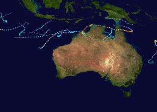
The 2014–15 Australian region cyclone season was a slightly below average tropical cyclone season, though it featured numerous intense cyclones. The season officially ran from 1 November 2014, to 30 April 2015, however, a tropical cyclone could form at any time between 1 July 2014, and 30 June 2015, and would count towards the season total. During the season, tropical cyclones were officially monitored, by one of the five Tropical Cyclone Warning Centres (TCWCs) that are operated in this region.

Tropical Cyclone Grant was a tropical cyclone that affected Queensland and the Northern Territory in late December 2011 and early January 2012.

Severe Tropical Cyclone Lam was the strongest storm to strike Australia's Northern Territory since Cyclone Monica in 2006. It formed from the monsoon trough on February 12, 2015 in the Coral Sea. For much of its duration, the system moved westward due to a ridge to the south. The system crossed over the Cape York Peninsula and moved into the Gulf of Carpentaria, whereupon it gradually organized due to warm waters and favorable outflow. On February 16, the Bureau of Meteorology (BoM) classified it as a Category 1 on the Australian tropical cyclone intensity scale and gave it the name Lam. The storm intensified further while drifting toward the Wessel Islands, developing an eye and strengthening to the equivalence of a minimal hurricane on February 18. It strengthened to reach maximum sustained winds of 185 km/h (115 mph) early on February 19 before turning to the southwest, making it a Category 4 cyclone. That day, it made landfall on Northern Territory between Milingimbi and Elcho Island at peak intensity, and it rapidly weakened over land. About six hours after Lam moved ashore, Cyclone Marcia struck Queensland as a Category 5 cyclone, marking the first time on record that two storms of Category 4 intensity struck Australia on the same day.

Severe Tropical Cyclone Peter was at the time, the wettest tropical cyclone on record in Australia, until it was surpassed by Cyclone Jasper in 2023. The third system and first severe tropical cyclone of the 1978–79 season, Peter developed on 29 December from a weak low pressure area over the Gulf of Carpentaria. Peter moved southeastward and deepened while brushing Arnhem Land. Initially a tropical low, it strengthened into a Category 1 cyclone by 12:00 UTC on 29 December. Peter intensified further on 30 December and became a Category 2 cyclone. On the following day, the cyclone peaked with maximum sustained winds of 110 km/h (70 mph). Peter weakened to a Category 1 cyclone before making landfall near the mouth of the Edward River in Queensland. While crossing the Cape York Peninsula, the storm weakened slowly. After reaching Pacific Ocean near Cooktown, the storm decelerated and meandered offshore, but dissipated just offshore on 4 January.

Severe Tropical Cyclone Kelvin was a strong tropical cyclone that impacted Western Australia in February 2018, causing moderate damage. The system was first identified as a weak tropical low on the morning of 11 February over the Northern Territory's Tiwi Islands by the Australian Bureau of Meteorology (BoM). The low moved southwestwards over land and emerged over the Indian Ocean near Broome on 16 February. The storm intensified into a Category 1 tropical cyclone on the following day, becoming the sixth named storm of the 2017–18 Australian region cyclone season. Kelvin subsequently moved slowly eastwards and began to rapidly intensify in the hours prior to landfall. On 18 February, the storm crossed the coast along Eighty Mile Beach as a Category 3 severe tropical cyclone on the Australian scale, and a high-end Category 1 hurricane-equivalent cyclone on the Saffir–Simpson scale. Despite being over land, Kelvin weakened at a slow rate over the next few days, and was downgraded to a tropical low on 19 February. The remnant low of the system drifted over the Outback before being last noted by BoM on 21 February.

Severe Tropical Cyclone Nora was a strong tropical cyclone that affected Far North Queensland and the northeastern Northern Territory during March 2018. The ninth named storm and third severe tropical cyclone of the 2017–18 Australian region cyclone season, Nora developed from a tropical low which formed near the Torres Strait on 19 March. The system initially moved quickly to the west-northwest, and then began tracking slowly southwestwards over the Arafura Sea while gradually developing. A turn to the east on 22 March brought the tropical low into a favourable environment for strengthening, and the system reached tropical cyclone intensity later that day. Nora then underwent a period of rapid intensification as it moved southeastwards into the Gulf of Carpentaria. The storm peaked on 23 March as a high-end Category 3 severe tropical cyclone with sustained winds of 155 km/h (96 mph) and a minimum barometric pressure of 958 hPa (28.29 inHg). Nora made landfall north of Pormpuraaw at about 13:00 UTC on 24 March as a minimal Category 3 system. Nora weakened steadily as it tracked southwards along the coast, and was downgraded to a tropical low the following day. Nora's remnants meandered over land for several days before moving back over the Gulf of Carpentaria and dissipating on 28 March.

Severe Tropical Cyclone Owen was an erratic and long-lived tropical cyclone that affected numerous regions along its track, especially Queensland, in December 2018. Owen was the fourth tropical low, first tropical cyclone, and first severe tropical cyclone of the 2018–19 Australian region cyclone season. Cyclone Owen developed on 29 November 2018 from an area of low pressure that was situated over the Solomon Islands; the system struggled to strengthen in a conflicting environment and degenerated to a tropical low on 3 December. The low drifted westward, and on 9 December, it made its first landfall in Queensland, before moving over the Gulf of Carpentaria, where more favourable conditions allowed it to re-organise. The system regenerated into a tropical cyclone on 12 December and rapidly intensified into a Category 3 severe tropical cyclone that night. At midnight on 13 December, Cyclone Owen made landfall in the Northern Territory, before turning eastward and reaching peak intensity, with sustained winds of 150 km/h (95 mph) and a minimum barometric pressure of 958 hPa (28.3 inHg). On 13 December, Owen made landfall on Queensland again, just north of the mouth of the Gilbert River near Kowanyama. The cyclone weakened rapidly after its third landfall, and the final advisory on Owen was issued on 15 December, after it had degenerated into a tropical low. However, the system persisted over the Coral Sea for another several days, before dissipating on 20 December.

Tropical Cyclone Tiffany was a strong tropical cyclone that made landfall in Queensland and the Northern Territory. The tenth tropical low and the fifth tropical cyclone of the 2021–22 Australian region cyclone season, Tiffany originated from a tropical low south of Papua New Guinea, before intensifying into a tropical cyclone and named Tiffany, peaking as a category 2 tropical cyclone before making landfall in northern Queensland.


