Exmouth is a town on the tip of the North West Cape and on Exmouth Gulf in Western Australia, 1,124 kilometres (698 mi) north of the state capital Perth and 2,060 kilometres (1,280 mi) southwest of Darwin.

Tropical Cyclone Steve was a tropical cyclone that affected northern Australia from 27 February 2000 until 11 March 2000. Cyclone Steve was noted for its longevity and traversal of northern and western Australia. It impacted on regions of northern Queensland, the Northern Territory and Western Australia before clearing to the south of the continent. Steve is the first known Australian cyclone to make four distinct landfalls in the country.

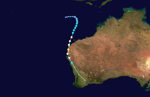
Severe Tropical Cyclone Vance was a tropical cyclone that struck Western Australia during the active 1998–99 Australian region cyclone season, and was also one of six tropical cyclones to form off the coast of Australia during that season. When making landfall the Learmonth Meteorological Office recorded the highest Australian wind gust of 267 km/h (166 mph). The previous highest gust was 259 km/h (161 mph) at nearby Mardie during Cyclone Trixie. This record was surpassed in 2010 after a world record wind-gust of 408 km/h (254 mph) at Barrow Island during Cyclone Olivia in 1996 was declared official by the World Meteorological Organisation.
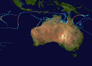
The 1999–2000 Australian region cyclone season was a slightly above average tropical cyclone season. It ran from 1 November 1999 to 30 April 2000. The regional tropical cyclone operational plan also defines a "tropical cyclone year" separately from a "tropical cyclone season", with the "tropical cyclone year" for this season lasting from 1 July 1999 to 30 June 2000.

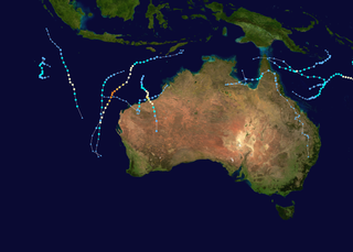
The 2003–04 Australian region cyclone season was a slightly below average tropical cyclone season. It began on 1 November 2003 and ended on 30 April 2004. The regional tropical cyclone operational plan also defines a tropical cyclone year separately from a tropical cyclone season, which runs from 1 July 2003 to 30 June 2004.

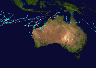
The 2002–03 Australian region cyclone season included Cyclone Inigo, which tied with Cyclone Gwenda in 1999 as the most intense tropical cyclone on record in the Australian basin. It began on 1 November 2002 and ended on 30 April 2003. The regional tropical cyclone operational plan also defines a tropical cyclone year separately from a tropical cyclone season, which runs from 1 July 2002 to 30 June 2003. These dates conventionally delimit the period of each year when most tropical cyclones form in the Australian region, which is defined as in the southern hemisphere between 90°E and 180°E. The season's ten tropical depressions existed within these dates, with the first, designated as Tropical Cyclone 07S, entering the basin on 27 December 2002. The last system, Cyclone Epi, dissipated on 6 June 2003. Tropical cyclones in this area were monitored by four Tropical Cyclone Warning Centres (TCWCs): the Australian Bureau of Meteorology (BOM) in Perth, Darwin, and Brisbane and one in Port Moresby, Papua New Guinea.
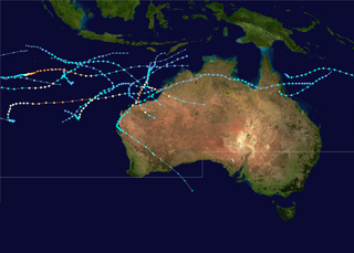
The 1998–99 Australian region cyclone season was an above average tropical cyclone season that featured Gwenda, the most intense tropical cyclone in the Australian Region. It began on 1 November 1998 and ended on 30 April 1999. The regional tropical cyclone operational plan also defines a tropical cyclone year separately from a tropical cyclone season, which runs from 1 July 1998 to 30 June 1999.

The 1995–96 Australian region cyclone season was an active Australian cyclone season, with Western Australia experiencing a record number of landfalling intense storms in the Pilbara region. The season produced a total of 19 tropical cyclones, of which 14 developed into named storms and 9 reached severe tropical cyclone status. The strongest of the season was Severe Tropical Cyclone Olivia, which also produced the highest recorded wind gust on record of 408 km/h (253 mph). Though several systems impacted land, the general sparsity of population centres in Australia limits the scale of damage. One person was confirmed to have been killed and cumulative losses were estimated at A$77 million (US$58.5 million).

The 2010–11 Australian region cyclone season was a near average tropical cyclone season, with eleven tropical cyclones forming compared to an average of 12. The season was also the costliest recorded in the Australian region basin, with a total of $3.62 billion in damages, mostly from the destructive Cyclone Yasi. The season began on 1 November 2010 and ended on 30 April 2011, although the first tropical cyclone formed on 28 October. The Australian region is defined as being to the south of the equator, between the 90th meridian east and 160th meridian east. Tropical cyclones in this area are monitored by five Tropical Cyclone Warning Centres (TCWC's): Jakarta, Port Moresby, Perth, Darwin, and Brisbane, each of which have the power to name a tropical cyclone. The TCWC's in Perth, Darwin, and Brisbane are run by the Bureau of Meteorology, who designate significant tropical lows with a number and the U suffix. The Joint Typhoon Warning Center also issues unofficial warnings for the region, designating significant tropical cyclones with the "S" suffix when they form west of 135°E, and the "P" suffix when they form east of 135°E.

Tropical Cyclone Herbie was the only known tropical system to impact Western Australia during the month of May on record. The final cyclone of the 1987–88 Australian region cyclone season, Herbie was first identified northwest of the Cocos Islands on 17 May. The following day, the system was classified as a tropical low by the Australian Bureau of Meteorology and intensified into a Category 1 cyclone later that day. Several hours after this upgrade, the storm attained its initial peak intensity with winds of 75 km/h. Around the same time, the Joint Typhoon Warning Center classified Herbie as Tropical Storm 21S.
The 2012–13 Australian region cyclone season was a slightly below average tropical cyclone season event in the ongoing cycle of tropical cyclone formation. It officially started on 1 November 2012, and officially ended on 30 April 2013, despite Cyclone Zane being an active system at the time. The regional tropical cyclone operational plan defines a "tropical cyclone year" separately from a "tropical cyclone season"; the "tropical cyclone year" began on 1 July 2012 and ended on 30 June 2013.
The 2013–14 Australian region cyclone season was a slightly below-average tropical cyclone season, with 10 tropical cyclones occurring within the Australian region. It officially started on 1 November 2013, and ended on 30 April 2014. The regional tropical cyclone operational plan defines a "tropical cyclone year" separately from a "tropical cyclone season"; the "tropical cyclone year" began on 1 July 2013 and ended on 30 June 2014.

The 2014–15 Australian region cyclone season was a slightly below average tropical cyclone season, though it featured numerous intense cyclones. The season officially ran from 1 November 2014, to 30 April 2015, however, a tropical cyclone could form at any time between 1 July 2014, and 30 June 2015, and would count towards the season total. During the season, tropical cyclones were officially monitored, by one of the five Tropical Cyclone Warning Centres (TCWCs) that are operated in this region.

The 2016–17 Australian region cyclone season, despite a very high number of tropical lows, was a slightly below-average season in terms of activity, with nine tropical cyclones, three of which intensified further into severe tropical cyclones; though it was much more active than the previous season. The season was the first to have a severe tropical cyclone since the 2014–15 season. It was the period of the year when most tropical cyclones form in the Southern Indian Ocean and Pacific Oceans between 90°E and 160°E. The season officially ran from 1 November 2016 to 30 April 2017, however, a tropical cyclone could form at any time between 1 July 2016 and 30 June 2017 and would count towards the season total. The first named storm, Yvette, developed during 21 December, and the final named storm, Greg, left the region on 3 May as a remnant low. This season was also the second-costliest tropical cyclone season on record in the Australian region basin, behind only the 2010–11 season, with a total of AUD$3.7 billion in damages incurred by the various storms, mostly from Cyclone Debbie.

Severe Tropical Cyclone John was an intense tropical cyclone that rapidly deepened offshore before devastating areas of Western Australia. The system was the second cyclone and first severe tropical cyclone of the active 1999–00 Australian region cyclone season. Cyclone John developed from a monsoon trough positioned northwest of Australia on 9 December 1999. As it moved to the west and later south as the result of a subtropical ridge under favourable conditions, the cyclone was able to rapidly intensify. John reached peak intensity on 14 December as a Category 5 cyclone on the Australian cyclone scale, the highest rating possible. Cyclone John later began interacting with a mid–latitude trough, which slightly weakened the cyclone prior to making landfall near Whim Creek early on 15 December. Increasingly unfavourable conditions further inland resulted in the cyclone's rapid weakening, before it dissipated during the next day.
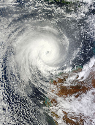
Severe Tropical Cyclone Narelle was a powerful Category 4 tropical cyclone in early January 2013 that brought light rains to areas in South Australia suffering from a drought and heat wave. On 4 January, a tropical low pressure developed within a monsoon trough over the Timor Sea. Over the following several days, the system gradually tracked westward and intensified, being classified Tropical Cyclone Narelle on 8 January. Turning southward into a region of low wind shear, Narelle intensified into a severe tropical cyclone on 9 January. Over the following two days, the cyclone's structure fluctuated, temporarily featuring an eye, before it maintained its organisation and intensified further on 11 January. The storm attained its peak intensity later on 11 January as a Category 4 cyclone with winds of 195 km/h (121 mph). The following day, Narelle passed approximately 330 km (205 mi) northwest of Exmouth as it moved on a south-southwesterly course. The system steadily weakened and ultimately fell below tropical cyclone strength on 15 January well to the west of Geraldton.

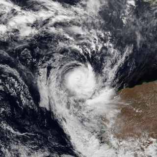
Severe Tropical Cyclone Christine was the third tropical cyclone and the second severe tropical cyclone of the 2013–14 Australian region cyclone season. It made landfall on Western Australia's Pilbara coast nearly halfway between the major towns of Karratha and Port Hedland as a category 4 cyclone on midnight of 31 December 2013.

During 2015, tropical cyclones formed in seven major bodies of water, commonly known as tropical cyclone basins. Tropical cyclones will be assigned names by various weather agencies if they attain maximum sustained winds of 35 knots. During the year, one hundred thirty-four systems have formed and ninety-two were named. The most intense storm of the year was Hurricane Patricia, with maximum 1-minute sustained wind speeds of 345 km/h (215 mph) and a minimum pressure of 872 hPa (25.75 inHg). The deadliest tropical cyclone was Cyclone Komen, which caused 280 fatalities in Southeast India and Bangladesh, while the costliest was Typhoon Mujigae, which caused an estimated $4.25 billion USD in damage after striking China. Forty Category 3 tropical cyclones formed, including nine Category 5 tropical cyclones in the year. The accumulated cyclone energy (ACE) index for the 2015, as calculated by Colorado State University (CSU) was 1047 units.
Severe Tropical Cyclone Elaine was a severe tropical cyclone which formed in the 1998–99 Australian region cyclone season. Elaine, along with Cyclone Vance, both made landfall and caused destruction in Western Australia. Elaine had made landfall on 20 March, while Vance made landfall on 23 March.

Severe Tropical Cyclone Carlos was a strong tropical cyclone that made landfall in Australia and resulted in $12.3 million USD in damages. Carlos was first spotted on 14 February near Batchelor and intensified to a Category 3 cyclone on 22 February. The storm affected Australia for most of its life.