
Estella (Spanish) or Lizarra (Basque) is a town located in the autonomous community of Navarre, in northern Spain. It lies south west of Pamplona, close to the border with La Rioja and Álava.

Stadio Partenopeo, also known as Stadio Giorgio Ascarelli, was a multi-use stadium in Naples, Italy. It was used mostly for football matches. The stadium was able to hold 40.000 people. During the 1934 World Cup, it hosted two games. The stadium was destroyed by bombardments during the Second World War.
Thirumalayampalayam is a panchayat town in Coimbatore district in the Indian state of Tamil Nadu. It is an important suburb of Coimbatore.
Stadion Lohmühle is a multi-use stadium in Lübeck, Germany. It is currently used mostly for football matches and is the home stadium of VfB Lübeck. The stadium is able to hold 17,849 people.

Milcz is a village in the administrative district of Gmina Chodzież, within Chodzież County, Greater Poland Voivodeship, in west-central Poland. It lies approximately 8 kilometres (5 mi) north of Chodzież and 72 km (45 mi) north of the regional capital Poznań.

The University of Opole is a public university in the city of Opole. It was founded in 1994 from a merger of two parallel educational institutions. The university has 17,500 students completing 32 academic majors and 53 specializations. The staff numbers 1,380 - among them are 203 professors and habilitated doctors and 327 doctors.
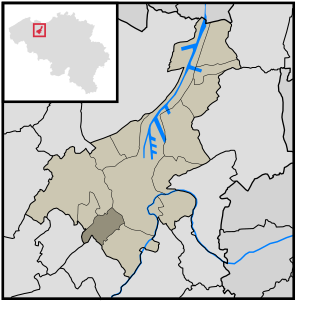
Sint-Denijs-Westrem is a village in the Belgian province of East Flanders. It is part of the city of Ghent, lying to the southwest of the city center, between Sint-Martens-Latem, De Pinte, Zwijnaarde and Afsnee.
Raciąż-Piaski is a village in the administrative district of Gmina Tuchola, within Tuchola County, Kuyavian-Pomeranian Voivodeship, in north-central Poland. It lies approximately 9 kilometres (6 mi) north-west of Tuchola and 63 km (39 mi) north of Bydgoszcz.
Bągart is a village in the administrative district of Gmina Płużnica, within Wąbrzeźno County, Kuyavian-Pomeranian Voivodeship, in north-central Poland.

Qazyan is a village in the Qubadli Rayon of Azerbaijan.
Szczawno Rzeczyckie is a settlement in the administrative district of Gmina Zadzim, within Poddębice County, Łódź Voivodeship, in central Poland.
Barwinek is a settlement in the administrative district of Gmina Kodrąb, within Radomsko County, Łódź Voivodeship, in central Poland. It lies approximately 4 kilometres (2 mi) north-east of Kodrąb, 17 km (11 mi) east of Radomsko, and 76 km (47 mi) south of the regional capital Łódź.
Dymacz is a village in the administrative district of Gmina Koźmin Wielkopolski, within Krotoszyn County, Greater Poland Voivodeship, in west-central Poland.
Shalcombe is a small settlement on the Isle of Wight towards the west in an area known as West Wight. It is in the civil parish of Shalfleet. It is situated along the B3399 road and is about 3.5 miles (5.6 km) east of Freshwater.
Osłonino is a village in the administrative district of Gmina Puck, within Puck County, Pomeranian Voivodeship, in northern Poland. It lies approximately 6 kilometres (4 mi) south-east of Puck and 36 km (22 mi) north of the regional capital Gdańsk.
Lipnica is a village in the administrative district of Gmina Szczecinek, within Szczecinek County, West Pomeranian Voivodeship, in north-western Poland. It lies approximately 7 kilometres (4 mi) south-west of Szczecinek and 139 km (86 mi) east of the regional capital Szczecin.
Słowenkowo is a village in the administrative district of Gmina Sławoborze, within Świdwin County, West Pomeranian Voivodeship, in north-western Poland. It lies approximately 8 kilometres (5 mi) north of Sławoborze, 21 km (13 mi) north of Świdwin, and 94 km (58 mi) north-east of the regional capital Szczecin.
Menzel Ennour is a town and commune in the Monastir Governorate, Tunisia.
Silla is a village in Lääne-Nigula Parish, Lääne County, in western Estonia.
Nové Lublice is a village in the Moravian-Silesian Region of the Czech Republic. As of February 10, 2006, the population was 220.


