Dairy Creek (Oregon)

Last updated
Dairy Creek
Dairy Creek Hillsboro Oregon.JPG
Dairy Creek just south of the Tualatin Valley Highway
USA Oregon location map.svg
Red pog.svg
Location of the mouth of Dairy Creek in Oregon
EtymologyProbably first used by Hudson's Bay Company employees who ran a dairy near the creek prior to 1840. [1]
Location
CountryUnited States
StateOregon
County Washington
Physical characteristics
SourceConfluence of East Fork Dairy Creek and West Fork Dairy Creek
 - locationnear Schefflin, Washington County, Oregon
 - coordinates 45°34′11″N123°04′22″W / 45.56972°N 123.07278°W / 45.56972; -123.07278 [2]
 - elevation151 ft (46 m) [3]
Mouth Tualatin River
 - locationnear Hillsboro, Washington County, Oregon
 - coordinates 45°30′06″N122°59′43″W / 45.50167°N 122.99528°W / 45.50167; -122.99528 Coordinates: 45°30′06″N122°59′43″W / 45.50167°N 122.99528°W / 45.50167; -122.99528 [2]
 - elevation128 ft (39 m) [2]
Length10.55 mi (16.98 km) [4]
Discharge 
 - locationEast Fork Dairy Creek, 12.3 miles (19.8 km) above confluence with West Fork Dairy Creek [5]
 - minimum6.9 cu ft/s (0.20 m3/s)
 - average76.9 cu ft/s (2.18 m3/s) [5]
 - maximum1,580 cu ft/s (45 m3/s)
Basin features
Basin size226 sq mi (590 km2) [6]

Dairy Creek is a 10.55-mile (16.98 km) tributary of the Tualatin River in the U.S. state of Oregon. It begins at the confluence of its east and west forks near the unincorporated community of Schefflin and meanders southeast across the Tualatin Valley to the Tualatin River near Hillsboro, in Washington County. East Fork Dairy Creek begins at 45°47′18″N123°02′29″W / 45.788446°N 123.041498°W / 45.788446; -123.041498 (Dairy Creek East Fork source) in Columbia County, slightly north of its border with Washington County, and flows generally south for 22 miles (35 km). West Fork Dairy Creek, also about 22 miles (35 km) long, forms at 45°45′19″N123°10′41″W / 45.7553899°N 123.178168°W / 45.7553899; -123.178168 (Dairy Creek West Fork source) , near the unincorporated community of Tophill, and flows generally southeast. [4] [7] [8] [9] Before railroads displaced river boats on the Tualatin, some steamships also worked the lower section of Dairy Creek, with plans to go as far up stream as Centerville. [10]

Tualatin River river in the United States of America

The Tualatin River is a tributary of the Willamette River in Oregon in the United States. The river is about 83 miles (134 km) long, and it drains a fertile farming region called the Tualatin Valley southwest and west of Portland at the northwest corner of the Willamette Valley. There are approximately 500,000 people residing on 15 percent of the land in the river's watershed.

Oregon State of the United States of America

Oregon is a state in the Pacific Northwest region on the West Coast of the United States. The Columbia River delineates much of Oregon's northern boundary with Washington, while the Snake River delineates much of its eastern boundary with Idaho. The parallel 42° north delineates the southern boundary with California and Nevada. Oregon is one of only three states of the contiguous United States to have a coastline on the Pacific Ocean.

Unincorporated area Region of land not governed by own local government

In law, an unincorporated area is a region of land that is not governed by a local municipal corporation; similarly an unincorporated community is a settlement that is not governed by its own local municipal corporation, but rather is administered as part of larger administrative divisions, such as a township, parish, borough, county, city, canton, state, province or country. Occasionally, municipalities dissolve or disincorporate, which may happen if they become fiscally insolvent, and services become the responsibility of a higher administration. Widespread unincorporated communities and areas are a distinguishing feature of the United States and Canada. In most other countries of the world, there are either no unincorporated areas at all, or these are very rare; typically remote, outlying, sparsely populated or uninhabited areas.

Contents

Course

Main stem

The roughly 10.6-mile (17.1 km) main stem of Dairy Creek begins at 45°34′11″N123°04′22″W / 45.569837°N 123.072885°W / 45.569837; -123.072885 (Dairy Creek source) at the confluence of its east and west forks. Flowing southeast, it receives Council Creek from the right 3.5 miles (5.6 km) from the mouth and McKay Creek from the left less than 1 mile (1.6 km) later. It passes under Oregon Route 8 (Tualatin Valley Highway) west of Hillsboro about 2 miles (3 km) from the mouth before entering the Tualatin River about 45 miles (72 km) from its confluence with the Willamette River. [4] [9]

Oregon Route 8 highway in Oregon

Oregon Route 8, also known as Oregon Highway 8, is an Oregon state highway which serves the western suburbs of Portland. The road is locally known as Canyon Road and Tualatin Valley Highway, and travels through the center of the Tualatin Valley. Oregon 8 is located entirely within Washington County. The portion of the route from US 26 to Oregon Route 47 is part of the National Highway System, listed as a principal arterial.

Willamette River major river in northwest Oregon

The Willamette River is a major tributary of the Columbia River, accounting for 12 to 15 percent of the Columbia's flow. The Willamette's main stem is 187 miles (301 km) long, lying entirely in northwestern Oregon in the United States. Flowing northward between the Oregon Coast Range and the Cascade Range, the river and its tributaries form the Willamette Valley, a basin that contains two-thirds of Oregon's population, including the state capital, Salem, and the state's largest city, Portland, which surrounds the Willamette's mouth at the Columbia.

West Fork

For roughly its first 6 miles (10 km), West Fork Dairy Creek flows south from near Tophill in northwestern Washington County. It passes under Oregon Route 47 twice, receives Cummings Creek from the right and Williams Creek from the left, and passes slightly west of Buxton 16 miles (26 km) from the main stem. Shortly thereafter, it crosses under U.S. Route 26 (Sunset Highway) and turns southeast. Running parallel to and south of Route 26 and the concurrent Route 47 for about 1 mile (2 km), it receives Burgholzer Creek from the right and Mendenhall Creek from the left, before again passing under Route 26, still concurrent with Route 47. Flowing parallel to and north of the highway for about another 5 miles (8 km), West Fork Dairy Creek receives Whitcher Creek from the left, Kuder Creek from the right, and Garrigus Creek from the left before flowing south under Route 26 for the third and last time 9.3 miles (15.0 km) from the confluence of the east and west forks. [4] [9]

Oregon Route 47 highway in Oregon

Oregon Route 47 is an Oregon state highway that runs between the Willamette Valley, near McMinnville, and the city of Clatskanie, along the Columbia River in the northwest part of the state. OR 47 traverses several highways of the Oregon state highway system: part of the Tualatin Valley Highway No. 29, part of the Nehalem Highway No. 102, part of the Sunset Highway No. 47, and the Mist–Clatskanie Highway No. 110.

Buxton, Oregon Unincorporated community in Oregon, United States

Buxton is an unincorporated community in Washington County, Oregon, United States, near Oregon Route 47.

U.S. Route 26 in Oregon highway in Oregon

U.S. Route 26 (US-26) is a major cross-state United States highway with its western terminus in the U.S. state of Oregon, connecting U.S. Route 101 on the Oregon Coast near Seaside with the Idaho state line east of Nyssa. Local highway names include the Sunset Highway No. 47, Mount Hood Highway No. 26, and John Day Highway No. 5 before continuing into Idaho and beyond.

The west fork passes under Route 47, no longer concurrent with Route 26, 7.7 miles (12.4 km) from the confluence. Shortly thereafter, the stream flows by Banks, which lies to its left. Below Banks, the stream receives Cedar Canyon Creek from the right, passes under Oregon Route 6 at 6.2 miles (10.0 km) from the confluence, turns east about 3 miles (4.8 km) later and flows under Route 47 again. It receives Lousignont Canal from the right about 2 miles (3 km) from the confluence before joining the East Fork Dairy Fork to form the main stem. [4] [9]

Banks, Oregon City in Oregon, United States

Banks is a city in Washington County, Oregon, United States which is located in the Tualatin Valley. It is the southern anchor to the Banks–Vernonia State Trail, which is a 21-mile (34 km) long linear trail popular with bicyclists, hikers, and equestrians. The population was 1,777 at the 2010 census. The community was named for John and Nancy Banks, who owned a nearby dairy farm. Incorporated in 1921, it is located in the western part of the county where Oregon Route 6 intersects Oregon Route 47.

Oregon Route 6 highway in Oregon

Oregon Route 6 is a state highway in the U.S. state of Oregon that runs between the city of Tillamook on the Oregon Coast, to the Willamette Valley, near Banks. OR 6 traverses the Wilson River Highway No. 37 of the Oregon state highway system, named after the river paralleling the highway's western segment.

East Fork

From its headwaters, East Fork Dairy Creek flows south for less than 1 mile (1.6 km) through Columbia County before entering Washington County 21.3 miles (34.3 km) from its confluence with the west fork. Over its next 10 miles (16 km), it receives Campbell Creek and Roundy Creek, both from the right, Panther Creek and Rock Creek, both from the left, Denny Creek from the right, Plentywater Creek and Meadow Brook Creek, both from the left, and Murtaugh Creek and Big Canyon, both from the right. At 12.3 miles (19.8 km) from the confluence, the stream passes United States Geological Survey (USGS) gauge 14205400. East Fork Dairy Creek flows under U.S. Route 26 about 6 miles (10 km) later. About 3 miles (5 km) downstream from Route 26, it receives Bledsoe Creek from the right before joining West Fork Dairy Creek to form the main stem. [4] [5] [9]

United States Geological Survey scientific agency of the United States government

The United States Geological Survey is a scientific agency of the United States government. The scientists of the USGS study the landscape of the United States, its natural resources, and the natural hazards that threaten it. The organization has four major science disciplines, concerning biology, geography, geology, and hydrology. The USGS is a fact-finding research organization with no regulatory responsibility.

Discharge

Creek at Dairy Creek Park in Hillsboro Dairy Creek Hillsboro Oregon 2.JPG
Creek at Dairy Creek Park in Hillsboro

The USGS monitors the flow of East Fork Dairy Creek at a station near the unincorporated community of Meacham Corner, 12.3 miles (19.8 km) from the confluence with the west fork and about 23 miles (37 km) from the mouth of Dairy Creek. The average flow at this station is 76.9 cubic feet per second (2.18 m3/s). This is from a drainage area of 33.8 square miles (87.5 km2), about 15 percent of the total Dairy Creek watershed. The maximum flow recorded there was 1,580 cubic feet per second (45 m3/s) in January 2003, and the minimum flow was 6.9 cubic feet per second (0.20 m3/s) in September 2007. [5]

See also

Related Research Articles

Clackamas River tributary of the Willamette River in Oregon

The Clackamas River is an approximately 83-mile (134 km) tributary of the Willamette River in northwestern Oregon, in the United States. Draining an area of about 940 square miles (2,435 km2), the Clackamas flows through mostly forested and rugged mountainous terrain in its upper reaches, and passes agricultural and urban areas in its lower third. The river rises in eastern Marion County, about 55 miles (89 km) east-southeast of Salem. The headwaters are on the slopes of Olallie Butte in the Mount Hood National Forest, about 10 miles (16 km) north of Mount Jefferson, at an elevation of 4,909 feet (1,496 m) in the Cascade Range. The Clackamas flows briefly north and then flows northwest through the mountains, passing through North Fork Reservoir and Estacada. It then emerges from the mountains southeast of Portland. It joins the Willamette near Oregon City and forms the boundary between Oregon City and Gladstone.

Marys River (Oregon) river in Oregon

Marys River is a 40-mile (64 km) tributary of the Willamette River in the U.S. state of Oregon. From its source at the confluence of its east and west forks near Summit, it flows generally southeast from the Central Oregon Coast Range to Corvallis.

Siletz River river in the United States of America

The Siletz River flows about 67 miles (108 km) to the Pacific Ocean through coastal mountains in the U.S. state of Oregon. Formed by the confluence of its north and south forks near Valsetz in Polk County, it winds through the Central Oregon Coast Range. The river, draining a watershed of 373 square miles (970 km2), empties into Siletz Bay, south of Lincoln City in Lincoln County. Although the river travels 67 miles (108 km) in river miles, its winding course begins only about 20 miles (32 km) east of the ocean, and its mouth and source latitudes are almost identical.

Elk River (Oregon) river in southwestern Oregon in the United States

The Elk River is in southwestern Oregon in the United States. About 29 miles (47 km) long, the river drains a remote 92-square-mile (240 km2) area of the Coast Range into the Pacific Ocean.

North Yamhill River river in the United States of America

The North Yamhill River is a 31-mile (50 km) tributary of the Yamhill River in the U.S. state of Oregon. It drains an area of the Northern Oregon Coast Range, as well as part of the Willamette Valley west of the Willamette River.

Alsea River river in the United States of America

The Alsea River flows 48.5 miles (78.1 km) from Alsea, an unincorporated community in the coastal mountains of the U.S. state of Oregon, to the Pacific Ocean near the city of Waldport. It begins at the confluence of the North Fork Alsea River and the South Fork Alsea River and ends in Alsea Bay, a wide estuary at Waldport. The river flows generally west-northwest in a winding course through the mountains of southern Benton and Lincoln counties, passing near the unincorporated community of Tidewater and through the Siuslaw National Forest. Its drainage basin extends into Lane County, along the headwaters of the South Fork Alsea River.

Trask River river in Oregon

The Trask River is in northwestern Oregon in the United States. It drains a mountainous timber-producing area of the Northern Oregon Coast Range west of Portland into Tillamook Bay and the Pacific Ocean. It is one of five rivers—the Tillamook, the Trask, the Wilson, the Kilchis, and the Miami—that flow into the bay.

Catoctin Creek is a 14.1-mile-long (22.7 km) tributary of the Potomac River in Loudoun County, Virginia, with a watershed of 59,000 acres (240 km2). Agricultural lands make up 67 percent and forests 30 percent of Catoctin Creek's watershed. It is the main drainage system for the northern Loudoun Valley, including all of the Catoctin Valley.

Salmon River (Clackamas County, Oregon) river in Oregons Cascade Range

The Salmon River is a 33.5-mile (53.9 km) river in the Cascade Range in the U.S. state of Oregon that drains part of southwestern Mount Hood. The entire length of the river is a protected National Wild and Scenic River. Several portions are in protected wilderness. It is affluent to the Sandy River, a tributary of the Columbia River.

Umatilla River tributary of the Columbia River in Oregon

The Umatilla River is an 89-mile (143 km) tributary of the Columbia River in the U.S. state of Oregon. Draining a basin of 2,450 square miles (6,300 km2), it enters the Columbia near the city of Umatilla in the northeastern part of the state. In downstream order, beginning at the headwaters, major tributaries of the Umatilla River are the North Fork Umatilla River and the South Fork Umatilla River, then Meacham, McKay, Birch, and Butter creeks.

Sol Duc River river in the United States of America

The Sol Duc River is a river in the U.S. state of Washington. About 78 miles (126 km) long, it flows west through the northwest part of the Olympic Peninsula, from the Olympic Mountains of Olympic National Park and Olympic National Forest, then through the broad Sol Duc Valley. Near the Pacific Ocean the Sol Duc River joins the Bogachiel River, forming the Quillayute River, which flows about 4 miles (6.4 km) to the Pacific Ocean at La Push. Although the Quillayute River is short, its large tributary rivers—the Sol Duc, Bogachiel, Calawah, and Dickey Rivers—drain the largest watershed of the northern Olympic Peninsula, 629 square miles (1,630 km2). The Sol Duc's watershed is the largest of the Quillayute's tributaries, at 219 square miles (570 km2).

Gales Creek (Oregon) river in the United States of America

Gales Creek, is a tributary, 23.5 miles (37.8 km) long, of the Tualatin River in Washington County, Oregon, United States. The headwaters of Gales Creek are on the north side of the mountain Round Top in the Northern Oregon Coast Range. The community of Gales Creek, Oregon, is near the creek, which further downstream forms the southwest border of the city of Forest Grove.

Fanno Creek river in the United States of America

Fanno Creek is a 15-mile (24 km) tributary of the Tualatin River in the U.S. state of Oregon. Part of the drainage basin of the Columbia River, its watershed covers about 32 square miles (83 km2) in Multnomah, Washington, and Clackamas counties, including about 7 square miles (18 km2) within the Portland city limits.

Oak Grove Fork Clackamas River river in the United States of America

Oak Grove Fork Clackamas River is a 21-mile (34 km) tributary of the Clackamas River in the U.S. state of Oregon. From its headwaters in the Warm Springs Indian Reservation near Abbot Pass in the Cascade Range, the river flows generally west through Mount Hood National Forest in Clackamas County to the unincorporated community of Ripplebrook. Here it enters the main stem of the Clackamas River. Oak Grove Fork feeds Timothy Lake and Lake Harriet, two artificial impoundments built along its course to control water flows to hydroelectric plants.

The Klamath River is a river in southern Oregon and northern California in the United States. This article describes its course.

Champoeg Creek stream in Oregon, USA

Champoeg Creek is a tributary, roughly 6 miles (9.7 km) long, of the Willamette River in the U.S. state of Oregon. The creek is formed by the confluence of its two forks in the French Prairie region of the Willamette Valley and flows generally northeast to meet the Willamette 45 miles (72 km) from the river's confluence with the Columbia River. Its course lies entirely in Marion County.

Course of the Willamette River

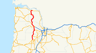
The Willamette River is a 187-mile (301 km) tributary of the Columbia River in the U.S. state of Oregon. The upper tributaries of the Willamette originate in mountains south and southeast of Eugene and Springfield. Formed by the confluence of the Middle Fork Willamette River and Coast Fork Willamette River near Springfield, the main stem meanders generally north from source to mouth. The river's two most significant course deviations occur at Newberg, where the stream turns sharply east, and about 18 miles (29 km) downriver from Newberg, where it turns north again. Near its mouth, the river splits into two channels that flow around Sauvie Island. The main channel enters the Columbia about 101 miles (163 km) from the larger stream's mouth on the Pacific Ocean, and the smaller Multnomah Channel enters the Columbia about 14.5 miles (23.3 km) further downstream near St. Helens in Columbia County.

South Fork Crooked River river in the United States of America

The South Fork Crooked River is a tributary, 76 miles (122 km) long, of the Crooked River in the U.S. state of Oregon. Starting southeast of Hampton in Deschutes County, the South Fork flows east from near Ram Lake (dry). It passes under U.S. Route 20 at Hampton, then continues east and north for about 6 miles (10 km) before entering Crook County. Shortly thereafter, east of Hampton Buttes, it receives Buck Creek from the right and then passes through Logan Reservoir. Flowing north, it receives Sand Hollow Creek from the left, then Twelvemile Creek from the right before crossing under Oregon Route 380. Just north of the highway, the river joins Beaver Creek to form the Crooked River 125 miles (201 km) from its confluence with the Deschutes River.

References

  1. McArthur, Lewis A.; McArthur, Lewis L. (2003). Oregon Geographic Names, Seventh Edition. Portland, Oregon: Oregon Historical Society Press. p. 265. ISBN   0-87595-277-1.
  2. 1 2 3 "Dairy Creek". Geographic Names Information System . United States Geological Survey. 1980-11-28. Retrieved 2008-11-26.
  3. Source elevation derived from Google Earth search using GNIS source coordinates.
  4. 1 2 3 4 5 6 Hedin, Darrell. "Tualatin Basin Stream Mile Index". Washington County Watermaster. Archived from the original on 2007-08-13.
  5. 1 2 3 4 "Water-data report 2007: 14205400 East Fork Dairy Creek near Meacham Corner, OR" (pdf). United States Geological Survey. Retrieved 2008-11-28.
  6. Bonn, Bernie. "Appendix I, River Mile Indices" (pdf). Tualatin River Flow Management Technical Committee 2007 Annual Report. Oregon Water Resources Department, District 18 Watermaster. p. I-5. Retrieved 2014-03-01.
  7. "East Fork Dairy Creek". Geographic Names Information System . United States Geological Survey. 1980-11-28. Retrieved 2008-11-27.
  8. "West Fork Dairy Creek". Geographic Names Information System . United States Geological Survey. 1980-11-28. Retrieved 2008-11-27.
  9. 1 2 3 4 5 Oregon Atlas & Gazetteer (Map) (1991 ed.). DeLorme Mapping. § 65. ISBN   0-89933-235-8.
  10. Johnston, Jerry (October 19, 1976). "Transportation: Navigation on Tualatin slowed by snags". Hillsboro Argus. p. 6.
Map all coordinates using: OpenStreetMap  
Download coordinates as: KML  ·  GPX