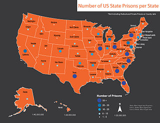
This is a list of U.S. state prisons (2010) :
The Upper Midwest is a region in the northern portion of the U.S. Census Bureau's Midwestern United States. It is largely a sub-region of the Midwest. Although there are no uniformly agreed-upon boundaries, the region is most commonly used to refer to the states of Minnesota, Wisconsin, Michigan, Iowa, South Dakota, and North Dakota.

The Territory of Minnesota was an organized incorporated territory of the United States that existed from March 3, 1849, until May 11, 1858, when the eastern portion of the territory was admitted to the Union as the State of Minnesota.

U.S. Route 16 (US 16) is an east–west United States Highway between Rapid City, South Dakota and Yellowstone National Park in Wyoming.
Blanchard is a census-designated place in Blanchard Township, Traill County, North Dakota in the United States. The population was 26 at the 2010 census.
Norwegian Americans are Americans with ancestral roots from Norway. Norwegian immigrants went to the United States primarily in the later half of the 19th century and the first few decades of the 20th century. There are more than 4.5 million Norwegian Americans, according to the most recent U.S. census,; most live in the Upper Midwest. Norwegian Americans are currently the 10th-largest European ancestry group in the United States.

The Red River Valley and Western Railroad is a regional railroad operating in the US states of North Dakota and Minnesota. It began operations in 1987 in an era of railroad restructuring.

The Lower Sioux Indian Reservation, also known as the Mdewakanton Tribal Reservation, is an Indian reservation located along the southern bank of the Minnesota River in Paxton and Sherman townships in Redwood County, Minnesota. Its administrative headquarters is two miles south of Morton. The reservation is located southeast of Redwood Falls, the county seat.

Homer is an unincorporated community and census-designated place (CDP) in Homer Township, Winona County, Minnesota, United States, on the south bank of the Mississippi River. As of the 2010 census, its population was 181.
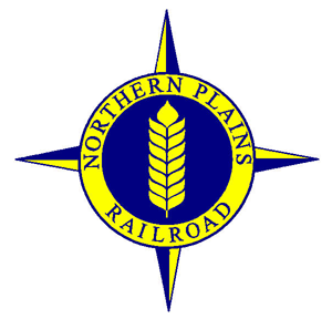
The Northern Plains Railroad is a short line railroad that operates over 344 miles of track in the northern U.S. state of Minnesota and the northern U.S. state of North Dakota.

The Dakota War of 1862, also known as the Sioux Uprising, the Dakota Uprising, the Sioux Outbreak of 1862, the Dakota Conflict, the U.S.–Dakota War of 1862 or Little Crow's War, was an armed conflict between the United States and several bands of Dakota. It began on August 17, 1862, along the Minnesota River in southwest Minnesota, four years after its admission as a state. Throughout the late 1850s in the lead-up to the war, treaty violations by the United States and late or unfair annuity payments by Indian agents caused increasing hunger and hardship among the Dakota. During the war, the Dakota made extensive attacks on hundreds of settlers and immigrants, which resulted in settler deaths, and caused many to flee the area. Intense desire for immediate revenge ended with soldiers capturing hundreds of Dakota men and interning their families. A military tribunal quickly tried the men, sentencing 303 to death for their crimes. President Lincoln would later commute the sentence of 264 of them. The mass hanging of 38 Dakota men was conducted on December 26, 1862, in Mankato, Minnesota; it was the largest mass execution in United States history.

The Minnesota Southern Railway was a shortline railroad in the states of Minnesota and South Dakota in the United States.
Robbin is an unincorporated community in Teien Township, Kittson County, Minnesota, United States.
Ottawa is an unincorporated community in Ottawa Township, Le Sueur County, Minnesota, United States.

Ridgeway is an unincorporated community in Pleasant Hill Township, Winona County, Minnesota, United States.
Pine Creek is an unincorporated community in Houston and Winona counties in the U.S. state of Minnesota.
Donehower is an unincorporated community in Richmond Township, Winona County, Minnesota, United States.
Waterford is an unincorporated community in Waterford Township, Dakota County, Minnesota, United States.
Lamoille is an unincorporated community in Richmond Township, Winona County, Minnesota, United States. Big Trout Creek and the Mississippi River meet at Lamoille.

Rapid City, Pierre and Eastern Railroad is a Class II railroad operating across South Dakota and southern Minnesota in the northern plains of the United States. Portions of the railroad also extend into Wyoming, and Nebraska. It is owned and operated by Genesee & Wyoming.


