Related Research Articles

Port Hope is a municipality in Southern Ontario, Canada, approximately 109 km (68 mi) east of Toronto and about 159 km (99 mi) west of Kingston. It is located at the mouth of the Ganaraska River on the north shore of Lake Ontario, in the west end of Northumberland County. Since 1868, the municipality has been the location of Trinity College School.

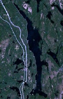
The Ganaraska River is a river in Northumberland County and the Regional Municipality of Durham in Southern Ontario, Canada. It is part of the Great Lakes Basin, and is a tributary of Lake Ontario, which it reaches at the central community of the municipality of Port Hope. The river's name is thought to originate from Ganaraske, the name for the Cayuga village which was located at the current site of Port Hope.

Scugog is a township in the Regional Municipality of Durham, south-central Ontario, Canada. It is northeast of Toronto and just north of Oshawa. The anchor and largest population base of the township is Port Perry. The township has a population of roughly 22,500. A smaller Scugog Township was also a historic municipality and geographic township prior to the amalgamation that formed the current municipality.

Port Weller, Ontario is a community in St. Catharines, Regional Municipality of Niagara, Ontario, Canada and is part of the Golden Horseshoe region. It is located 8 kilometres (5.0 mi) north of the centre of St. Catharines at the north end of the Welland Canal at Lake Ontario, but part of that city in much the same way as Port Dalhousie.
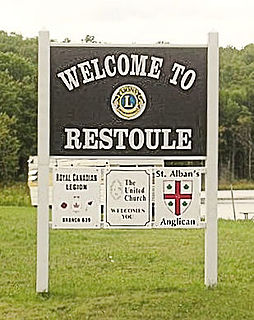
Restoule is a community and designated place in geographic Patterson Township in the Centre Unorganized Part of Parry Sound District in Central Ontario, Canada. It is situated on the Restoule River between Commanda Lake, and Restoule Lake and is part of the Almaguin Highlands region.

Clearview is a rural incorporated township in Simcoe County in Central Ontario, Canada, west of Barrie and south of Collingwood and Wasaga Beach in Simcoe County.
The Bayfield River is a river in Huron and Perth Counties in southwestern Ontario, Canada, that empties into Lake Huron at the community of Bayfield in the municipality of Bluewater.
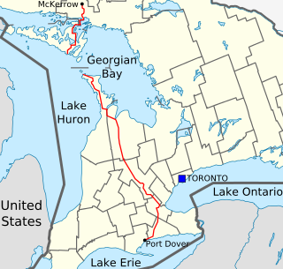
King's Highway 6, commonly referred to as Highway 6, is a provincially maintained highway in the Canadian province of Ontario. It crosses a distance of 480 km (300 mi) between Port Dover, on the northern shore of Lake Erie, and Espanola, on the northern shore of Lake Huron, before ending at the Trans-Canada Highway (Highway 17) in McKerrow.

The Municipality of Arran–Elderslie is a township in Bruce County in Western Ontario, Canada. The township is located at the headwaters of the Sauble River, and the Saugeen River forms the northwestern boundary.

The Township of Ashfield–Colborne–Wawanosh is a municipality in Huron County, Ontario, Canada. It was formed as an amalgamation of the former Ashfield, Colborne and West Wawanosh townships in 2001, in an Ontario-wide local government restructuring imposed by the government of that time. The three former townships now comprise the wards of the amalgamated municipality. Mayor of Dungannon Robert Brindley Jr.
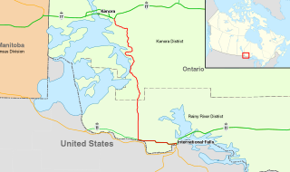
King's Highway 71, commonly referred to as Highway 71, is a provincially maintained highway in the Canadian province of Ontario. The 194-kilometre-long (121 mi) route begins at the Fort Frances–International Falls International Bridge in Fort Frances, continuing from US Highway 53 (US 53) and US 71 in Minnesota, and travels west concurrently with Highway 11 for 40 kilometres (25 mi) to Chapple. At that point, Highway 11 continues west while Highway 71 branches north and travels 154 kilometres (96 mi) to a junction with Highway 17 just east of Kenora. Highway 71 is part of the Trans-Canada Highway for its entire length, with the exception of the extremely short segment south of Highway 11 in Fort Frances.

Cloyne is a small village in the township of Addington Highlands, Lennox and Addington County, Ontario, Canada. It is located on Highway 41 about 20 kilometres (12 mi) by road north of Kaladar at the crossroads of Highway 41 with Highway 7, with the settlements of Bishop Corners and Northbrook in between, and 43 kilometres (27 mi) by road south of Denbigh, with the settlements of Ferguson Corners and Vennachar Junction in between.

Brown's Corners is an unincorporated community in Markham, Regional Municipality of York in the Greater Toronto Area of Ontario, Canada and located near the corner of Woodbine Avenue and Highway 7. The community, founded in 1842, was named for local settler Alexander Brown, Sr. (1771–1851) who acquired 100 acres (40 ha) in 1838. Beaver Creek flows through it.

South Algonquin is a township municipality in Nipissing District, Ontario, Canada. Located south of Algonquin Provincial Park, it is the sole populated portion of the district that lies south of the traditional dividing line between Northern Ontario and Southern Ontario and is closer connected to Renfrew County as opposed to the core portions of Nipissing District.

Algonquin Highlands is a township located in Haliburton County, Ontario, Canada. It has a population of 2,351. The northeastern section of the township is included in Algonquin Provincial Park.
Shabaqua Corners is a dispersed rural community and unincorporated area in geographic Dawson Road Lots Township in the Unorganized Part of Thunder Bay District in Northwestern Ontario, Canada. It is 56 kilometres (35 mi) west of Thunder Bay at the junction of Ontario Highway 17 and Ontario Highway 11; both highways at this point are part of the Trans-Canada Highway. There is an Ontario Provincial Police detachment in the community. The Oskondaga River flows through the community to its mouth at the Shebandowan River just to the south.

Queensborough is an unincorporated community in the municipality of Tweed, Hastings County, in Central Ontario, Canada. It is located north of Ontario Highway 7 on the Black River, about 20 kilometres (12 mi) north-west of the village of Tweed and 15 kilometres (9.3 mi) north-east of the town of Madoc.
Rib Lake is a long and narrow lake in the Town of Latchford and in the Municipality of Temagami in Northeastern Ontario, Canada, located about 9 kilometres (6 mi) southeast of the centre of the community of Latchford and 9 kilometres (6 mi) northeast of the community of Temagami North. The lake is in the Ottawa River drainage basin and is the main access for canoeists en route to Rib Mountain.

Welcome is a community in the municipality of Port Hope, Northumberland County, Ontario, Canada. It is located at the crossroads of County Road 10, heading north to the community of Canton; County Road 74, heading east to Dale; and County Road 2 heading west to Morrish and southeast to interchange 461 on Ontario Highway 401 and further southeast to the town centre of Port Hope.

Millhaven Creek is a stream in the municipalities of Loyalist, Lennox and Addington County, and South Frontenac, Frontenac County, and the single-tier municipality of Kingston in eastern Ontario, Canada. It is a tributary of Lake Ontario and is under the auspices of the Cataraqui Region Conservation Authority.
References
- "Dale". Geographical Names Data Base . Natural Resources Canada . Retrieved 2010-06-09.
- "Toporama - Topographic Map Sheets 30M16, 31D1". Atlas of Canada . Natural Resources Canada. Archived from the original on 2010-08-31. Retrieved 2010-06-09.
| | This Ontario location article is a stub. You can help Wikipedia by expanding it. |