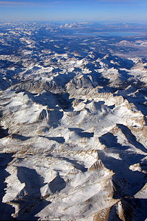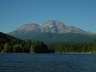
The Sierra Nevada is a mountain range in the Western United States, between the Central Valley of California and the Great Basin. The vast majority of the range lies in the state of California, although the Carson Range spur lies primarily in Nevada. The Sierra Nevada is part of the American Cordillera, an almost continuous chain of mountain ranges that forms the western "backbone" of the Americas.

The Humboldt–Toiyabe National Forest (HTNF) is the principal U.S. National Forest in the U.S. state of Nevada, and has a smaller portion in Eastern California. With an area of 6,289,821 acres (25,454.00 km2), it is the largest U.S. National Forest outside Alaska.

Lassen Volcanic National Park is an American national park in northeastern California. The dominant feature of the park is Lassen Peak, the largest plug dome volcano in the world and the southernmost volcano in the Cascade Range. Lassen Volcanic National Park is one of the few areas in the world where all four types of volcano can be found—plug dome, shield, cinder cone, and stratovolcano.

The Carson River is a northwestern Nevada river that empties into the Carson Sink, an endorheic basin. The main stem of the river is 131 miles (211 km) long although the addition of the East Fork makes the total length 205 miles (330 km), traversing five counties: Alpine County in California and Douglas, Storey, Lyon, and Churchill Counties in Nevada, as well as the Consolidated Municipality of Carson City, Nevada. The river is named for Kit Carson, who guided John C. Frémont's expedition westward up the Carson Valley and across Carson Pass in winter, 1844. The river made the National Priorities List (NPL) on October 30, 1990 as the Carson River Mercury Superfund site (CRMS) due to investigations that showed trace amounts of mercury in the wildlife and watershed sediments.

Wheeler Peak is the highest natural point in the U.S. state of New Mexico. It is located northeast of Taos and south of Red River in the northern part of the state, and just 2 miles (3.2 km) southeast of the ski slopes of Taos Ski Valley. It lies in the Sangre de Cristo Mountains, the southernmost subrange of the Rocky Mountains. The peak's elevation is 13,167 feet (4,013 m).

Stanislaus National Forest is a U.S. National Forest which manages 898,099 acres of land in four counties in the Sierra Nevada in Northern California. It was established on February 22, 1897, making it one of the oldest national forests. It was named after the Stanislaus River.

Sonora Pass is the second-highest highway pass in the Sierra Nevada, lower by 321 ft. than Tioga Pass to the south. State Route 108 traverses the pass.
The Upper Truckee River is a stream that flows northward from the western slope of Red Lake Peak in Alpine County, California to Lake Tahoe via the Truckee Marsh in South Lake Tahoe, California. The river flows northeasterly and is 23 miles (37 km) long. It is Lake Tahoe's largest tributary.

Diamond Peak is a volcano in Klamath and Lane counties of central Oregon in the United States. It is a shield volcano, though it might also be considered a modest stratocone. Diamond Peak forms part of the Cascade Volcanic Arc, a segment of the Cascade Range in western North America extending from southern British Columbia through Oregon to Northern California. Reaching an elevation of 8,748 feet (2,666 m), the mountain is located near Willamette Pass in the Diamond Peak Wilderness within the Deschutes and Willamette national forests. Surrounded by coniferous forest and visible in the skyline from foothills near Eugene, Diamond Peak offers a few climbing routes and can be scrambled. Diamond Peak is one of Oregon's Matterhorns.

The Golden Trout Wilderness is a federally designated wilderness area in the Sierra Nevada, in Tulare County and Inyo County, California. It is located 40 miles (64 km) east of Porterville, California within Inyo National Forest and Sequoia National Forest.

The Caribou Wilderness is a federally designated wilderness area created by the Wilderness Act of 1964 and is part of the National Wilderness Preservation System. It is located 60 miles (97 km) east of Redding in the state of California, United States. The Caribou Wilderness comprises 20,546 acres (83.15 km2) and is adjacent to the east side of Lassen Volcanic National Park. Although the park is surrounded by Lassen National Forest, it is managed separately by the National Park Service, whereas the U.S. Forest Service manages the wilderness.

The Carson–Iceberg Wilderness is a federal wilderness area located 80 miles (130 km) northeast of Stockton, California. It encompasses 160,000 acres (650 km2) and was designated by the California Wilderness Act of 1984. It protects an area of High Sierra landscape with elevations from 4,800 feet (1,500 m) to 11,462 feet (3,494 m) along the Sierra Mountains from Ebbetts Pass to Sonora Pass in the south. The US Forest Service manages the wilderness which is in both the Stanislaus National Forest and the Humboldt–Toiyabe National Forest.

The Mount Shasta Wilderness is a 38,200-acre (155 km2) federally designated wilderness area located 5 miles (8.0 km) east of Mount Shasta City in northern California. The US Congress passed the 1984 California Wilderness Act that set aside the Mount Shasta Wilderness. The US Forest Service is the managing agency as the wilderness is within the Shasta-Trinity National Forest. The area is named for and is dominated by the Mount Shasta volcano which reaches a traditionally quoted height of 14,162 feet (4,317 m) above sea level, but official sources give values ranging from 14,104 feet (4,299 m) from one USGS project, to 14,179 feet (4,322 m) via the NOAA. Mount Shasta is one of only two peaks in the state over 14,000 feet (4,300 m) outside the Sierra Nevada Mountain Range. The other summit is White Mountain Peak in the Great Basin of east-central California.

The Dardanelles and Freel Roadless Areas are located 7 miles (11 km) and 3 miles (4.8 km), respectively, south of Lake Tahoe, California, and both are managed by the Lake Tahoe Basin Management Unit of the US Forest Service.These areas are contiguous, separated only by the corridor of highway 89. The historic Hawley Grade, an immigrant wagon road, now a hiking trail, is within the Dardanelles Roadless Area, as well as the watershed of Lake Tahoe's largest inflow, the Upper Truckee River.

The East Fork Carson River is the largest tributary of the Carson River, flowing through California and Nevada in the western United States. The north-flowing river is 61 miles (98 km) long and drains a mostly rural, mountainous watershed of 392 square miles (1,020 km2).

The Tahoe–Yosemite Trail (TYT) is a long-distance trail in the Sierra Nevada mountain range of California. The trail courses 186 miles (299 km) from Meeks Bay at Lake Tahoe to Tuolumne Meadows in Yosemite National Park. The trail is a foot and equestrian path that passes through the Desolation, Mokelumne, Carson-Iceberg, Emigrant, and Yosemite Wilderness Areas and the Meiss Country (Dardanelles) Roadless Area.

The Donnell Fire was a wildfire that started on August 1, 2018 due to an unattended campfire, near Donnell Reservoir, burning around California State Route 108 in Tuolumne County, California and in the Stanislaus National Forest. It spread rapidly, and the Forest Service closed a California state highway, many forest service roads, campgrounds, wilderness areas, access to privately-owned inholdings, and the Pacific Crest Trail. The fire burned 36,450 acres (147.5 km2), and destroyed 54 major structures and 81 minor structures, before the fire burned out on October 1. There were nine injuries caused by the fire, but no deaths.
The Dardanelles is a strait and internationally significant waterway in northwestern Turkey.
The protected areas of the Sierra Nevada, a major mountain range located in the U.S. states of California and Nevada, are numerous and highly diverse. Like the mountain range itself, these areas span hundreds of miles along the length of the range, and over 14,000 feet of elevation from the lowest foothills to the summit of Mount Whitney.

Highland Peak is a prominent 10,936-foot-elevation mountain summit located in the Sierra Nevada mountain range, in Alpine County of northern California, United States. It is situated 3.5 miles east of Ebbetts Pass in the Carson-Iceberg Wilderness, on land managed by Humboldt–Toiyabe National Forest. Although it ranks as the 680th highest summit in California, it ranks 36th highest of those with at least 500 meters of topographic prominence. Highland Peak has a subsidiary South Peak, with one-half mile separation between summits. The Pacific Crest Trail traverses the western foot of this mountain, providing an approach option.


