
The Black Country is an area of England's West Midlands. It is mainly urban, covering most of the Dudley and Sandwell metropolitan boroughs, with the Metropolitan Borough of Walsall and the City of Wolverhampton sometimes included. The towns of Dudley and Tipton are generally considered to be the centre.

Walsall is a market town and administrative centre of the borough of the same name in the West Midlands, England. Historically part of Staffordshire, it is located 9 miles (14 km) northwest of Birmingham, 7 miles (11 km) east of Wolverhampton and 9 miles (14 km) southwest of Lichfield.
Tipton is an industrial town in the metropolitan borough of Sandwell, in the county of the West Midlands, England. It had a population of 38,777 at the 2011 UK Census. It is located northwest of Birmingham and southeast of Wolverhampton. It is also contiguous with nearby towns of Darlaston, Dudley, Wednesbury and Bilston.

Wednesbury is a market town in the Sandwell district, in the county of the West Midlands, England - historically in Staffordshire. It is located near the source of the River Tame, and is part of the Black Country. Wednesbury is situated 5 miles (8km) south-east of Wolverhampton, 3 miles (4.4km) south-west of Walsall, and 7 miles (11.8km) north-west of Birmingham. At the 2021 Census, the town's built-up area had a population of 20,313.

The West Midlands conurbation is the large conurbation in the West Midlands region of England. The area consists of two cities and numerous towns: to the east, the city of Birmingham, along with adjacent towns of Solihull and Sutton Coldfield; and to the west, the city of Wolverhampton and the area called the Black Country, containing the towns of Dudley, Walsall, West Bromwich, Oldbury, Willenhall, Bilston, Darlaston, Tipton, Smethwick, Wednesbury, Rowley Regis, Stourbridge and Halesowen.

Willenhall is a market town in the Walsall district, in the county of the West Midlands, England, with a population taken at the 2021 Census of 49,587. It is situated between Wolverhampton and Walsall, historically in the county of Staffordshire. It lies upon the River Tame, and is contiguous with both Wolverhampton and parts of South Staffordshire. The M6 motorway at Junction 10 separates it from Walsall.
The Metropolitan Borough of Walsall is a metropolitan borough in the West Midlands, England. It is named after its largest settlement, Walsall, but covers a larger area which also includes Aldridge, Bloxwich, Brownhills, Darlaston, Pelsall and Willenhall.

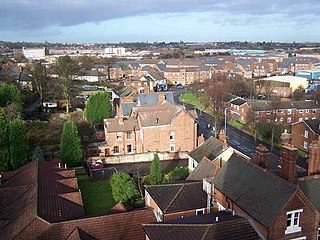
Darlaston is an industrial town in the Metropolitan Borough of Walsall in the West Midlands of England. It is located near Bilston, Walsall, Wednesbury, Willenhall and Tipton. It was historically part of Staffordshire.

Moxley is a village near Darlaston in the Metropolitan Borough of Walsall, West Midlands County, England. It was first developed during the early part of the 19th century when a handful of terraced houses were built to accommodate locals working in factories and mines and the area was created in 1845 out of land from Darlaston, Bilston and Wednesbury.

A civil parish is a subnational entity, forming the lowest unit of local government in England. There are 21 civil parishes in the ceremonial county of West Midlands, most of the county being unparished; Dudley, Sandwell, Walsall and Wolverhampton are completely unparished. At the 2001 census, there were 89,621 people living in the parishes, accounting for 3.5 per cent of the county's population.

Walsall South was a constituency in the West Midlands in the House of Commons of the UK Parliament. It was represented since 1974 until abolition by members of the Labour Party.

Coal Aston is a village in the civil parish of Dronfield, in the North East Derbyshire district, in the county of Derbyshire, England. It is by the town of Dronfield.

Darlaston James Bridge railway station was a station built on the Grand Junction Railway in 1837, serving the James Bridge area east of the town centre of Darlaston, near the junction of Walsall Road and Bentley Mill Way.

The Walsall Canal is a narrow canal, seven miles (11 km) long, forming part of the Birmingham Canal Navigations, and passing around the western side of Walsall, West Midlands, England.
The Ghost Town Trail is a rail trail in Western Pennsylvania that runs 36 miles (58 km) between Black Lick, Indiana County, and Ebensburg, Cambria County. Established in 1991 on the right-of-way of the former Ebensburg and Black Lick Railroad, the trail follows the Blacklick Creek and passes through many ghost towns that were abandoned in the early 1900s with the decline of the local coal mining industry. Open year-round to cycling, hiking, and cross-country skiing, the trail is designated a National Recreation Trail by the United States Department of the Interior.

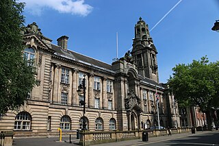
Walsall Council, formally Walsall Metropolitan Borough Council, is the local authority for the Metropolitan Borough of Walsall in the West Midlands, England. The town of Walsall had been a borough from medieval times, which was reformed on numerous occasions. Since 1974 the council has been a metropolitan borough council. It provides the majority of local government services in the borough. The council has been a member of the West Midlands Combined Authority since 2016.
The South Staffordshire and Birmingham District Steam Tramways Company which became the South Staffordshire Tramways Company operated a tramway service from their depot in Wednesbury between 1883 and 1924.
Sliabh an Iarainn, anglicized Slieve Anierin, is a mountain in County Leitrim, Ireland. It rises to 585 metres (1,919 ft) and lies east of Lough Allen and northeast of Drumshanbo. It is part of the Cuilcagh Mountains. The mountain was shaped by the southwestward movement of ice age glaciers over millions of years, the morainic drift heaping thousands of drumlins in the surrounding lowlands. Historically there were many iron ore deposits and ironworks in the area. Irish mythology associates the mountain with the Tuatha Dé Danann, particularly the smith god Goibniu. Sliabh an Iarainn is an important natural heritage site with exposed marine and coastal fauna of paleontological interest

King's Hill is an area between Wednesbury and Darlaston in the Metropolitan Borough of Walsall in the West Midlands county in England. It is located to the southeast of Darlaston town centre and close to the Junction 9 of the M6 motorway between Bescot and Wednesbury. It is primarily a residential estate and is close to the towns of Walsall and Wednesbury. It forms part of the Walsall Metropolitan Boroughs boundary with Sandwell. Also nearby is the Wednesbury suburb of Wood Green and its former railway station.

