Walsall Canal

Last updated • 3 min readFrom Wikipedia, The Free Encyclopedia

Walsall Canal
Bridge no more - Walsall Canal - geograph.org.uk - 902721.jpg
Site of a removed bridge on the canal
Specifications
Length7 miles (11 km)
Locks8
StatusNavigable
History
Date of act1784
Geography
Connects to Wyrley and Essington Canal
Wednesbury Old Canal
Walsall Canal

The Walsall Canal is a narrow (7 feet or 2.1 metres) canal, seven miles (11 km) long, forming part of the Birmingham Canal Navigations, and passing around the western side of Walsall, West Midlands, England.

Contents

Route

Walsall Canal
BSicon uSTRq.svg
BSicon uFABZq+lr.svg
BSicon uSTRq.svg
Birchills Junction, Wyrley and Essington Canal
BSicon uhSTRae.svg
Aqueduct over dismantled Wolverhampton and Walsall Railway
BSicon uLOCKSu.svg
65 ft
Walsall Locks (8)
BSicon uFABZgl+l.svg
BSicon uDOCKr.svg
Walsall Town Arm
BSicon uSKRZ-Bu.svg
M6 motorway
BSicon uhSTRae.svg
Aqueduct
BSicon gKHSTaq.svg
BSicon gFABZq+lr.svg
BSicon ugFABZgr+r.svg
Arrow Blue Left 001.svg Anson Branch
BSicon POINTERg@fq.svg
BSicon gSTR.svg
BSicon uSTR.svg
Bentley Canal
BSicon umKRZo.svg
Grand Junction Railway
BSicon uSTR.svg
BSicon uSTR+r.svg
BSicon ugFABZgr+r.svg
Arrow Blue Left 001.svg Willenhall Branch
BSicon gSTR.svg
BSicon ugFABZgr+r.svg
Arrow Blue Left 001.svg Bilston Branch
BSicon gFABZgl+l.svg
BSicon ugLOCKSl.svg
BSicon ugFABZgr+r.svg
Arrow Blue Left 001.svg Bradley Branch (9 locks), Moorcroft Junction
BSicon POINTERg@fq.svg
BSicon gSTR.svg
BSicon uSTR.svg
Wednesbury Oak Loop (BCN Old Main Line)
BSicon gSTRr.svg
BSicon umKRZu.svg
West Midlands Metro
BSicon gKHSTaq.svg
BSicon uSTRq.svg
BSicon uFABZgr+r.svg
Arrow Blue Left 001.svg Gospel Oak Branch
BSicon uFABZgl+l.svg
BSicon uSTRq.svg
Tame Valley Junction, Tame Valley Canal Arrow Blue Right 001.svg
BSicon gdSTRq.svg
BSicon exPUMPHOUSE.svg
BSicon gdSTRq.svg
BSicon uFABZgr+r.svg
Arrow Blue Left 001.svg Ocker Hill Branch pumped from Ocker Hill Tunnel Branch
BSicon gdSTRq.svg
BSicon ugLOCKSl.svg
BSicon gdSTRq.svg
BSicon ugFABZgr+r.svg
Arrow Blue Left 001.svg Toll End Communication Canal
BSicon uemKRZu.svg
South Staffordshire line
BSicon ugFABZgr+r.svg
BSicon gSTR.svg
Arrow Blue Left 001.svg Haynes Branch, Wednesbury Old Canal Arrow Blue Up 001.svg
BSicon uLOCKSd.svg
BSicon gFABZgl+l.svg
45 ft
Ryders Green Locks (8), Swan Bridge Jn, Ridgacre Branch Arrow Blue Right 001.svg
BSicon uSTR+l.svg
BSicon uFABZqlr.svg
BSicon uSTRr.svg
Arrow Blue Left 001.svg Wednesbury Old Canal Arrow Blue Right 001.svg, Ryders Green Junction
BSicon POINTERg@fq.svg
BSicon uSTR.svg
Wednesbury Old Canal
BSicon uSTRq.svg
BSicon uFABZqlr.svg
BSicon uSTRq.svg
BSicon uSTRq.svg
BCN New Main Line (Island Line), Pudding Green Junction

The canal runs from Ryders Green Junction where it meets the Wednesbury Old Canal and immediately drops through the eight Ryders Green Locks to the 408-foot (124 m) Walsall Level. At Doe Bank Junction (Tame Valley Junction) it meets the Tame Valley Canal and the very short Ocker Hill Tunnel Branch, now private moorings, which fed water to the Ocker Hill pumps to replenish the Wolverhampton Level. It passes northwards, past the junction of the derelict Gospel Oak Branch and under the West Midlands Metro line, and passes the short Bradley Branch at Moorcroft Junction. In this area it passes the site of huge iron gates of the Patent Shaft factory (these gates have now been resited to a traffic island by the bus station in Wednesbury). It then passes the short Anson Branch (which once led to the Bentley Canal, abandoned 1961) and under the M6 motorway just south of junction 10. The very short Walsall Town Arm at Walsall Junction leads into Walsall itself while the main canal rises through eight locks to meet the Wyrley & Essington Canal at Birchills Junction.

The canal starts at the Birmingham Level, descends 45 feet (14 m) to the Walsall Level, then rises 65 feet (20 m) to the Wolverhampton Level.

History

The canal was built in four distinct stages. It started life as the Broadwaters Extension to the Wednesbury Canal which opened in 1785 to serve collieries in Moxley. This section was authorised as a detached part of the Birmingham & Fazeley Canal under that canal's original Act. [1]

Meanwhile from the other direction, the Birchills Branch of the Wyrley and Essington Canal reached Bloxwich Wharf to the north-west of Walsall by 1798. [2] (Much of this branch from Sneyd Junction was later subsumed into the new mainline of the Wyrley and Essington, when that canal was extended towards Huddlesford, leaving about 700 metres (2,300 ft) of the Birchills Branch as a stub.)

What was by then known as the Birmingham and Birmingham and Fazeley Canal Company (soon to be incorporated as the Birmingham Canal Navigations Company) was authorised by the combined company's sixth Act of Parliament on 17 April 1794 to extend the canal from Broadwaters to Walsall. It allowed the Company to borrow £45,000, with which to construct the canal to Walsall and three branches to serve iron-stone and coal mines in the locality, all to be completed within three years. [3] Construction began at Broadwaters and reached Darlaston by May 1798. [4] The second phase of construction began in April 1798: excavation was completed in 1799 but the job remained unfinished in 1800. [5]

The canal was mapped by John Snape (1737–1816) in 1808 and this was to be his last known map. [6]

The small gap between the Birmingham Canal Navigations line to Walsall and the Wyrley and Essington Canal's Birchills Branch was of concern to businessmen to the north of Walsall, whose access to the south was by a very circuitous route. An independent canal to link the two was planned, but in 1839 the BCN agreed to build a connection. [7] The Walsall Junction Canal was completed in March 1841, [8] its 0.6 miles (0.97 km) containing eight locks and completing the through route.

Points of interest

Point Coordinates
(Links to map resources)
OS Grid Ref Notes
Ryders Green Junction 52°31′22″N2°01′20″W / 52.5228°N 2.0221°W / 52.5228; -2.0221 (Ryders Green Junction) SO985916 Wednesbury Old Canal
Toll End Junction 52°32′14″N2°02′08″W / 52.5372°N 2.0356°W / 52.5372; -2.0356 (Toll End Junction) SO976932 Toll End Communication Canal
Ocker Hill Tunnel Branch 52°32′22″N2°02′09″W / 52.5394°N 2.0357°W / 52.5394; -2.0357 (Ocker Hill Tunnel Branch) SO976934
Tame Valley Junction (Doe Bank Junction) 52°32′24″N2°02′07″W / 52.5400°N 2.0354°W / 52.5400; -2.0354 (Tame Valley Junction) SO976935 Tame Valley Canal
Gospel Oak Branch Junction 52°32′57″N2°02′13″W / 52.5493°N 2.0370°W / 52.5493; -2.0370 (Gospel Oak Branch Junction) SO975945
Moorcroft Junction 52°33′15″N2°02′28″W / 52.5541°N 2.0411°W / 52.5541; -2.0411 (Moorcroft Junction) SO972951 Bradley Branch
Anson Branch Junction 52°34′39″N2°01′20″W / 52.5775°N 2.0221°W / 52.5775; -2.0221 (Anson Branch Junction) SO986977 Anson Branch, leading to Bentley Canal
Walsall Junction 52°35′05″N1°59′34″W / 52.5848°N 1.9928°W / 52.5848; -1.9928 (Walsall Junction) SP005986Short branch to Walsall centre
Birchills Junction 52°35′55″N1°59′52″W / 52.5987°N 1.9979°W / 52.5987; -1.9979 (Birchills Junction) SK002000 Wyrley and Essington Canal

From north to south:

See also

Related Research Articles

<span class="mw-page-title-main">Birmingham and Fazeley Canal</span> Canal in the United Kingdom

The Birmingham and Fazeley Canal is a canal of the Birmingham Canal Navigations in the West Midlands of England. Its purpose was to provide a link between the Coventry Canal and Birmingham and thereby connect Birmingham to London via the Oxford Canal.

<span class="mw-page-title-main">Wyrley and Essington Canal</span> Narrow canal in the Midlands, England

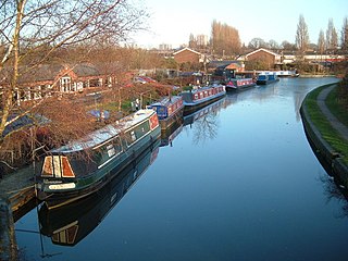
The Wyrley and Essington Canal, known locally as "the Curly Wyrley", is a canal in the English Midlands. As built it ran from Wolverhampton to Huddlesford Junction near Lichfield, with a number of branches: some parts are currently derelict. Pending planned restoration to Huddlesford, the navigable mainline now terminates at Ogley Junction near Brownhills. In 2008 it was designated a Local Nature Reserve.

<span class="mw-page-title-main">Birmingham Canal Navigations</span> United Kingdom legislation

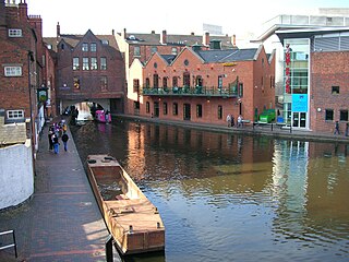
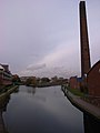
Birmingham Canal Navigations (BCN) is a network of canals connecting Birmingham, Wolverhampton, and the eastern part of the Black Country. The BCN is connected to the rest of the English canal system at several junctions. It was owned and operated by the Birmingham Canal Navigation Company from 1767 to 1948.

<span class="mw-page-title-main">Bentley Canal</span>

The Bentley Canal is an abandoned canal that was part of the Birmingham Canal Navigations. A very short section still exists where it joins the Wyrley and Essington Canal in Wolverhampton. From there it headed generally southeast through Willenhall and Walsall and connected with the Anson Branch and thus the Walsall Canal. The main line opened in 1843, with the Neachell Hall Branch following two years later. The branch closed in 1953 and the main line in the early 1960s.

<span class="mw-page-title-main">Lichfield Canal</span> English canal under restoration

The Lichfield Canal, as it is now known, was historically a part of the Wyrley and Essington Canal, being the section of that canal from Ogley Junction at Brownhills on the northern Birmingham Canal Navigations to Huddlesford Junction, east of Lichfield, on the Coventry Canal, a length of 7 miles (11.3 km). The branch was abandoned in 1955, along with several other branches of the Wyrley and Essington, and much of it was filled in.

<span class="mw-page-title-main">Tame Valley Canal</span>

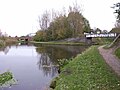
The Tame Valley Canal is a relatively late (1844) canal in the West Midlands of England. It forms part of the Birmingham Canal Navigations. It takes its name from the roughly-parallel River Tame.

<span class="mw-page-title-main">Anson Branch</span> Canal in West Midlands, England

The Anson Branch is a short canal in the West Midlands, England. It runs for just over one mile from its junction with the Walsall Canal near Forster's bridge. It forms part of the Birmingham Canal Navigations.

<span class="mw-page-title-main">Water levels of the Birmingham Canal Navigations</span>

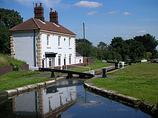
The Birmingham Canal Navigations (BCN), a network of narrow canals in the industrial midlands of England, is built on various water levels. The three longest are the Wolverhampton, Birmingham, and Walsall levels. Locks allow boats to move from one level to another.

<span class="mw-page-title-main">Rushall Junction</span> Canal junction

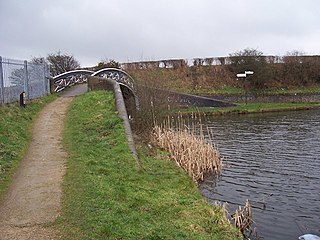
Rushall Junction is the southern limit of the Rushall Canal where it meets the Tame Valley Canal in the West Midlands, England. It opened in 1847, when the Rushall Canal was built to create connections between the Birmingham Canal Navigations system and the Wyrley and Essington Canal, following the amalgamation of the two companies in 1840.

<span class="mw-page-title-main">Tame Valley Junction</span> Canal junction

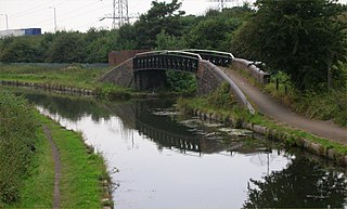
Tame Valley Junction, also known as Doe Bank Junction, is a canal junction at the western limit of the Tame Valley Canal where it meets the Walsall Canal, south of Walsall, in the West Midlands, England.

<span class="mw-page-title-main">Horseley Fields Junction</span>

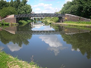
Horseley Fields Junction is a canal junction at the western limit of the Wyrley and Essington Canal where it meets the BCN Main Line, at Horseley Fields east of Wolverhampton, in the West Midlands, England.

<span class="mw-page-title-main">Huddlesford Junction</span> Canal junction in Staffordshire, England

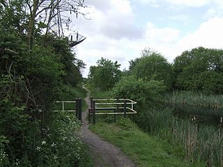
Huddlesford Junction is a canal junction at the original north-eastern limit of the Wyrley and Essington Canal where it met the Coventry Canal, near Lichfield, in Staffordshire, England.

<span class="mw-page-title-main">Ogley Junction</span> Canal junction in the English Midlands

Ogley Junction, on the Staffordshire county border near Brownhills, West Midlands, England, is a historic canal junction on the Wyrley and Essington Canal where the Anglesey Branch left the main line.

<span class="mw-page-title-main">Catshill Junction</span> Canal junction in West Midlands, England

Catshill Junction is a canal junction at the northern limit of the Daw End Branch Canal where it meets the Wyrley and Essington Canal main line, near Brownhills, in West Midlands, England.

<span class="mw-page-title-main">Pelsall Junction</span> Canal junction in England

Pelsall Junction is a canal junction at the southern limit of the Cannock Extension Canal where it meets the Wyrley and Essington Canal main line, near Pelsall, West Midlands, England.

<span class="mw-page-title-main">Birchills Junction</span> Canal junction in the uk

Birchills Junction is the canal junction at the northern limit of what is now called the Walsall Canal where it meets the Wyrley and Essington Canal main line, near Walsall, West Midlands, England. It opened in 1798, but lasted for little more than a year, until it was re-opened in 1841 when a connecting link was built to the Birmingham Canal Navigations' southern route to Walsall.

<span class="mw-page-title-main">Rumer Hill Junction</span> Canal junction in England

Rumer Hill Junction was a canal junction on the Cannock Extension Canal where the Churchbridge Branch left to join the Hatherton Canal. The junction, along with the northern section of the canal was abandoned in 1963. The Churchbridge Branch and Rumer Hill Junction were subsequently obliterated by opencast mining.

<span class="mw-page-title-main">Wednesbury Old Canal</span> Canal in the West Midlands, England

Wednesbury Old Canal is part of the Birmingham Canal Navigations (BCN) in the English West Midlands. It opened in 1769, and although parts of it were abandoned in 1955 and 1960, the section between Pudding Green Junction and Ryder's Green Junction is navigable, as it provides a link to the Walsall Canal. A short stub beyond Ryder's Green Junction is connected to the network but difficult to navigate.

<span class="mw-page-title-main">Wednesbury Oak Loop</span>

The Wednesbury Oak Loop, sometimes known as the Bradley Arm, is a canal in the West Midlands, England. It is part of the Birmingham Canal Navigations (BCN), and was originally part of James Brindley's main line, but became a loop when Thomas Telford's improvements of the 1830s bypassed it by the construction of the Coseley Tunnel. The south-eastern end of the loop was closed and in parts built over, following the designation of the entire loop as "abandoned" in 1954, including the section which was filled in at the beginning of the 1960s to make way for the Glebefields Estate in Tipton.

<span class="mw-page-title-main">Bradley Branch</span>

The Bradley Branch or Bradley Locks Branch was a short canal of the Birmingham Canal Navigations in the West Midlands, England. Completed in 1849, it included nine locks, and had a number of basins which enabled it to service local collieries and industrial sites. The locks were unusual, as they had a single gate at both ends, rather than double gates at the bottom end. The route closed in the 1950s, and the top seven locks were covered over and landscaped.

References

  1. Shill, Ray (2005). Birmingham and the Black Country's Canalside Industries. Tempus Publishing. ISBN   0-7524-3262-1. p33
  2. Paget-Tomlinson, Edward (1993). The Illustrated History of Canal & River Navigations. Sheffield Academic Press. ISBN   1-85075-277-X. p217
  3. Joseph Priestley, (1831), Historical Account of the Navigable Rivers, Canals, and Railways, of Great Britain
  4. Shill, Ray (2005). Birmingham and the Black Country's Canalside Industries. Tempus Publishing. ISBN   0-7524-3262-1. p44
  5. Shill, Ray (2005). Birmingham and the Black Country's Canalside Industries. Tempus Publishing. ISBN   0-7524-3262-1. p45
  6. A. W. Skempton (2002). A Biographical Dictionary of Civil Engineers in Great Britain and Ireland. Thomas Telford. ISBN   0-7277-2939-X.
  7. Shill, Ray (2005). Birmingham and the Black Country's Canalside Industries. Tempus Publishing. ISBN   0-7524-3262-1. p98
  8. Broadbridge, S. R. (1974). The Birmingham Canal Navigations, Vol. 1 1768 - 1846. David & Charles. ISBN   0-7509-2077-7. p73

52°35′05″N1°59′34″W / 52.5848°N 1.9928°W / 52.5848; -1.9928