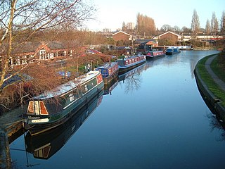
Anson Branch

Last updated

Anson Branch
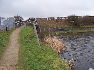
Monarch's Way, Anson Branch Canal.jpg
The canal near Bentley Mill Bridge
Specifications
Locks0
Statusderelict but watered
History
Original ownerBirmingham Canal Navigations
Date of act1768
Date of first use1830
Geography
Start pointBentley Mines
End pointWalsall Canal
Branch(es)Bentley Canal (defunct)
Branch ofWalsall Canal
Anson Branch
BSicon ugDOCKf.svg
Bentley mines and quarry
BSicon gSTR.svg
BSicon ugDOCKf.svg
BSicon gSTRl.svg
BSicon gABZg+r.svg
BSicon gFABZgl+l.svg
BSicon ugDOCKr.svg
Basin
BSicon gSKRZ-Eu.svg
Bentley Lane
BSicon uexSKRZ-Eu.svg
Bloxwich Lane
BSicon uexSTR.svg
BSicon uexSKRZ-Bu.svg
M6 motorway Jn 10
BSicon uexSKRZ-Eu.svg
Bentley Mill Way
BSicon gCONTgq.svg
BSicon uexFABZgr+r.svg
Bentley Canal
BSicon uexKRZo.svg
River Tame Aqueduct
BSicon uexSTR.svg
BSicon uSTR+l.svg
BSicon uFABZqlr.svg
BSicon uCONTfq.svg
Walsall Canal
BSicon umKRZo.svg
Aqueduct
BSicon uSKRZ-Yu.svg
Foresters Bridge
BSicon uCONTf.svg

The Anson Branch is a short canal in the West Midlands, England. It runs for just over one mile from its junction with the Walsall Canal near Forster's bridge. It forms part of the Birmingham Canal Navigations.

Contents

The canal is only partially watered and is no longer navigable. It formerly connected with the now defunct Bentley Canal which, in turn, connected with the Wyrley and Essington Canal. The canal has no locks.

History

The branch was authorised by the Birmingham Canal Navigation Act 1768 (8 Geo. 3. c. 38), but was not completed until 1830. [1] It was surveyed by Thomas Telford, who estimated that it would cost £9,499 to build. The route had to cross the River Tame, just to the north of the junction with the Walsall Canal, and this required an aqueduct and an embankment. Telford wanted Thomas Townsend to build it, but he was not keen to accept the contract, as he believed that Telford's estimate was too low. However, he was persuaded, and the contract was signed in March 1830. [2]

It was built to serve the coal mines and a limestone quarry in Bentley, [3] which were owned by the Earl of Lichfield. From the Walsall Canal, it headed in a north-easterly direction, and was almost straight for most of its length, apart from near the mines, where it turned to the north to reach a wharf, from which horse tramways connected to the Bentley mines and furnaces. By 1832, several blast furnaces had also been built near to the terminal basin. In order to tap into the mineral resources further to the north, the Bradford Branch was proposed, but only a small section was built as a canal, and the rest was constructed as a narrow-gauge tramway. It was completed in 1840, and was owned and operated by the canal company. [2]

Following the amalgamation of the Wyrley and Essington Canal with the Birmingham Canal Navigations on 9 February 1840, the new company were keen to create junctions between the two systems. The Bentley Canal was one of these, and ran from the Anson Branch to the Wyrley and Essington at Wednesfield. [4] It opened in 1843. [1]

By the 1890s, many of the mines had been worked out, and the local industry was in serious decline in the early twentieth century. However, the canal found a new use, when a power station was built at Birchills. Construction began in 1914, and some of it was operational by 1916, although it was not officially finished until 1922. It required a water supply, and a pumping station with two Mather and Platt pumps was installed beside the canal. The pumps could deliver 10.6 million gallons (48 Megalitres) per day, and once the water had passed through the power station, it was discharged into the Wyrley and Essington Canal to supply the Wolverhampton level of the Birmingham Canal Navigations. As a result, a pumping station near the top of Birchills locks was switched off and dismantled. From 1927, the power station became the responsibility of West Midlands Joint Electricity Authority, and then the British Electricity Authority following nationalisation in 1948. A second power station was commissioned in 1949. [2]

The section above the Bentley Canal junction was abandoned as a navigation in 1956, and the Bentley Canal and the rest of the Anson Branch were abandoned in 1961. [1] When the M6 motorway was built, it crossed the route of the branch, but because of its water supply function, a culvert was provided. It was large enough for small maintenance craft to pass through, although would not be considered large enough for modern pleasure craft. The power station was decommissioned in 1980, and the pumps were switched off, since when the branch has gradually deteriorated. [2]

The remains of the branch, covering an area of 13.6 acres (5.5 ha), have been designated as a site of local importance for nature conservation (SLINC) by Walsall Council. [5]

The junction with the Walsall Canal, which runs left and right Anson Junction.jpg
The junction with the Walsall Canal, which runs left and right

Points of interest

Point Coordinates
(Links to map resources)
OS Grid Ref Notes
Northern terminus 52°35′34″N2°00′24″W / 52.5929°N 2.0067°W / 52.5929; -2.0067 (Northern terminus) SO995994Bentley mines and quarry
Bentley Canal Junction 52°34′52″N2°01′06″W / 52.5812°N 2.0182°W / 52.5812; -2.0182 (Bentley Canal Junction) SO987981
Anson Branch Junction 52°34′39″N2°01′20″W / 52.5775°N 2.0221°W / 52.5775; -2.0221 (Anson Branch Junction) SO986977Southern terminus at junction with Walsall Canal

See also

Bibliography

Related Research Articles

<span class="mw-page-title-main">Wyrley and Essington Canal</span> Narrow canal in the Midlands, England

The Wyrley and Essington Canal, known locally as "the Curly Wyrley", is a canal in the English Midlands. As built it ran from Wolverhampton to Huddlesford Junction near Lichfield, with a number of branches: some parts are currently derelict. Pending planned restoration to Huddlesford, the navigable mainline now terminates at Ogley Junction near Brownhills. In 2008 it was designated a Local Nature Reserve.
<span class="mw-page-title-main">Birmingham Canal Navigations</span> United Kingdom legislation

Birmingham Canal Navigations (BCN) is a network of canals connecting Birmingham, Wolverhampton, and the eastern part of the Black Country. The BCN is connected to the rest of the English canal system at several junctions. It was owned and operated by the Birmingham Canal Navigation Company from 1767 to 1948.
<span class="mw-page-title-main">Bentley Canal</span>

The Bentley Canal is an abandoned canal that was part of the Birmingham Canal Navigations. A very short section still exists where it joins the Wyrley and Essington Canal in Wolverhampton. From there it headed generally southeast through Willenhall and Walsall and connected with the Anson Branch and thus the Walsall Canal. The main line opened in 1843, with the Neachell Hall Branch following two years later. The branch closed in 1953 and the main line in the early 1960s.

<span class="mw-page-title-main">Lichfield Canal</span> English canal under restoration

The Lichfield Canal, as it is now known, was historically a part of the Wyrley and Essington Canal, being the section of that canal from Ogley Junction at Brownhills on the northern Birmingham Canal Navigations to Huddlesford Junction, east of Lichfield, on the Coventry Canal, a length of 7 miles (11.3 km). The branch was abandoned in 1955, along with several other branches of the Wyrley and Essington, and much of it was filled in.

<span class="mw-page-title-main">Cannock Extension Canal</span>

The current Cannock Extension Canal is a 1.8-mile (2.9 km) canal in England. It runs from Pelsall Junction on the Wyrley and Essington Canal, north to Norton Canes Docks and forms part of the Birmingham Canal Navigations. Historically, it ran to Hednesford, and served a number of collieries, which provided the main traffic. It opened in 1863, and the northern section closed in 1963, as a result of mining subsidence.

<span class="mw-page-title-main">Water levels of the Birmingham Canal Navigations</span>

The Birmingham Canal Navigations (BCN), a network of narrow canals in the industrial midlands of England, is built on various water levels. The three longest are the Wolverhampton, Birmingham, and Walsall levels. Locks allow boats to move from one level to another.

<span class="mw-page-title-main">Titford Canal</span>

The Titford Canal is a narrow (7 foot) canal, a short branch of the Birmingham Canal Navigations (BCN) in Oldbury, West Midlands, England.

<span class="mw-page-title-main">Walsall Canal</span>

The Walsall Canal is a narrow canal, seven miles (11 km) long, forming part of the Birmingham Canal Navigations, and passing around the western side of Walsall, West Midlands, England.
<span class="mw-page-title-main">Rushall Junction</span> Canal junction

Rushall Junction is the southern limit of the Rushall Canal where it meets the Tame Valley Canal in the West Midlands, England. It opened in 1847, when the Rushall Canal was built to create connections between the Birmingham Canal Navigations system and the Wyrley and Essington Canal, following the amalgamation of the two companies in 1840.

<span class="mw-page-title-main">Tame Valley Junction</span> Canal junction

Tame Valley Junction, also known as Doe Bank Junction, is a canal junction at the western limit of the Tame Valley Canal where it meets the Walsall Canal, south of Walsall, in the West Midlands, England.

<span class="mw-page-title-main">Horseley Fields Junction</span>

Horseley Fields Junction is a canal junction at the western limit of the Wyrley and Essington Canal where it meets the BCN Main Line, at Horseley Fields east of Wolverhampton, in the West Midlands, England.

<span class="mw-page-title-main">Huddlesford Junction</span> Canal junction in Staffordshire, England

Huddlesford Junction is a canal junction at the original north-eastern limit of the Wyrley and Essington Canal where it met the Coventry Canal, near Lichfield, in Staffordshire, England.
<span class="mw-page-title-main">Ogley Junction</span> Canal junction in the English Midlands

Ogley Junction, on the Staffordshire county border near Brownhills, West Midlands, England, is a historic canal junction on the Wyrley and Essington Canal where the Anglesey Branch left the main line.

<span class="mw-page-title-main">Catshill Junction</span> Canal junction in West Midlands, England

Catshill Junction is a canal junction at the northern limit of the Daw End Branch Canal where it meets the Wyrley and Essington Canal main line, near Brownhills, in West Midlands, England.

<span class="mw-page-title-main">Pelsall Junction</span> Canal junction in England

Pelsall Junction is a canal junction at the southern limit of the Cannock Extension Canal where it meets the Wyrley and Essington Canal main line, near Pelsall, West Midlands, England.

<span class="mw-page-title-main">Birchills Junction</span> Canal junction in the uk

Birchills Junction is the canal junction at the northern limit of what is now called the Walsall Canal where it meets the Wyrley and Essington Canal main line, near Walsall, West Midlands, England. It opened in 1798, but lasted for little more than a year, until it was re-opened in 1841 when a connecting link was built to the Birmingham Canal Navigations' southern route to Walsall.

<span class="mw-page-title-main">Rumer Hill Junction</span> Canal junction in England

Rumer Hill Junction was a canal junction on the Cannock Extension Canal where the Churchbridge Branch left to join the Hatherton Canal. The junction, along with the northern section of the canal was abandoned in 1963. The Churchbridge Branch and Rumer Hill Junction were subsequently obliterated by opencast mining.

<span class="mw-page-title-main">Wednesbury Oak Loop</span>

The Wednesbury Oak Loop, sometimes known as the Bradley Arm, is a canal in the West Midlands, England. It is part of the Birmingham Canal Navigations (BCN), and was originally part of James Brindley's main line, but became a loop when Thomas Telford's improvements of the 1830s bypassed it by the construction of the Coseley Tunnel. The south-eastern end of the loop was closed and in parts built over, following the designation of the entire loop as "abandoned" in 1954, including the section which was filled in at the beginning of the 1960s to make way for the Glebefields Estate in Tipton.

<span class="mw-page-title-main">Bradley Branch</span>

The Bradley Branch or Bradley Locks Branch was a short canal of the Birmingham Canal Navigations in the West Midlands, England. Completed in 1849, it included nine locks, and had a number of basins which enabled it to service local collieries and industrial sites. The locks were unusual, as they had a single gate at both ends, rather than double gates at the bottom end. The route closed in the 1950s, and the top seven locks were covered over and landscaped.

Birchills power station and Walsall power station are a series of three coal-fired power stations in, or near, Walsall in the West Midlands, England.

References

  1. 1 2 3 Hadfield 1985 , pp. 318–319
  2. 1 2 3 4 Shill 2011
  3. Russell 1971 , p. 141
  4. Hadfield 1985 , p. 99
  5. "Walsall Council: SLINCs". Archived from the original on 29 May 2008. Retrieved 11 May 2008.

52°34′39″N2°01′20″W / 52.5775°N 2.0221°W / 52.5775; -2.0221