Birmingham Canal Navigations (BCN) is a network of canals connecting Birmingham, Wolverhampton, and the eastern part of the Black Country. The BCN is connected to the rest of the English canal system at several junctions.

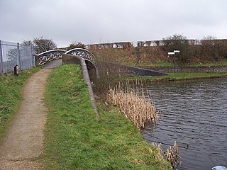
The Spon Lane Locks Branch is an 800-yard section of the BCN Main Line canal in Oldbury, England, which forms a connecting canal "sliproad" where the Old BCN Main Line crosses the New BCN Main Line at the Stewart Aqueduct. It runs westwards from Spon Lane Junction via the three Spon Lane Locks to Bromford Junction. It was originally part of the Wednesbury branch of Birmingham Canal which opened in 1769. At the top lock, there is a rare example of a split bridge, which enabled a horse to cross the canal without being detached from the barge. The rope passed through a gap at the centre of the bridge between its two halves. However, this particular example is a modern reconstruction, dating from 1986. These are probably the oldest working locks in the country. There is pedestrian access to a tow path for its entire length, but being narrow and muddy, it is not suitable for cyclists.

Netherton Tunnel Branch Canal, in the English West Midlands, is part of the Birmingham Canal Navigations, (BCN). It was constructed at a 453–foot elevation, the Wednesbury or Birmingham level; it has no locks. The total length of the branch canal is 2.4 miles (3.9 km) and the canal tunnel is 9,081 feet (2,768 m) long.

The Stour Valley Line is the historic and colloquial name for the line of the Birmingham, Wolverhampton and Stour Valley Railway Company between Birmingham and Bushbury, just north of Wolverhampton in the West Midlands, England. It now forms part of the "Birmingham Loop" or "Rugby–Birmingham–Stafford Line" of the West Coast Main Line. The "Stour Valley" was a branch which was never built, yet it gives its name to the whole section.
The Centre of the Earth is a purpose-built environmental education centre in Birmingham, England, run by the Wildlife Trust for Birmingham and the Black Country.

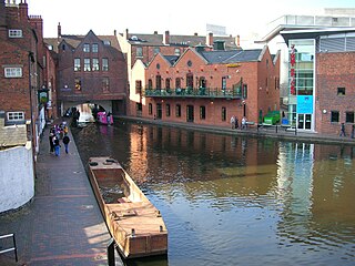
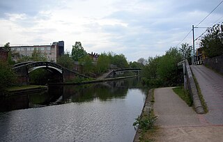
Old Turn Junction, or Deep Cutting Junction is a canal junction in Birmingham, England, where the Birmingham and Fazeley Canal meets the Birmingham Canal Navigations Main Line Canal. The junction features a circular island.
The Harborne Railway was a short railway branch line that connected the city centre of Birmingham, England with the outlying suburb of Harborne.

The current Cannock Extension Canal is a 1.8-mile (2.9 km) canal in England. It runs from Pelsall Junction on the Wyrley and Essington Canal, north to Norton Canes Docks and forms part of the Birmingham Canal Navigations. Historically, it ran to Hednesford, and served a number of collieries, which provided the main traffic. It opened in 1863, and the northern section closed in 1963, as a result of mining subsidence.

The Titford Canal is a narrow (7 foot) canal, a short branch of the Birmingham Canal Navigations (BCN) in Oldbury, West Midlands, England.

The Rushall Canal is a straight, 2.75-mile (4.43 km), narrow canal suitable for boats which are 7 feet (2.1 m) wide, forming part of the Birmingham Canal Navigations (BCN) on the eastern side of Walsall, West Midlands, England.

Horseley Fields Junction is a canal junction at the western limit of the Wyrley and Essington Canal where it meets the BCN Main Line, at Horseley Fields east of Wolverhampton, in the West Midlands, England.
Ogley Junction, on the Staffordshire county border near Brownhills, West Midlands, England, is a historic canal junction on the Wyrley and Essington Canal where the Anglesey Branch left the main line.

Catshill Junction is a canal junction at the northern limit of the Daw End Branch Canal where it meets the Wyrley and Essington Canal main line, near Brownhills, in West Midlands, England.

Pelsall Junction is a canal junction at the southern limit of the Cannock Extension Canal where it meets the Wyrley and Essington Canal main line, near Pelsall, West Midlands, England.
Wednesbury Old Canal is part of the Birmingham Canal Navigations (BCN) in West Midlands (county), England. It opened in 1769, and although parts of it were abandoned in 1955 and 1960, the section between Pudding Green Junction and Ryder's Green Junction is navigable, as it provides a link to the Walsall Canal, while a short stub beyond Ryder's Green Junction is also navigable.
Bromford Junction is a canal junction at the foot of the Spon Lane Locks where the Spon Lane Locks Branch meets the BCN New Main Line near Oldbury in the West Midlands, England.

The Wednesbury Oak Loop, sometimes known as the Bradley Arm, is a canal in the West Midlands, England. It is part of the Birmingham Canal Navigations (BCN), and was originally part of James Brindley's main line, but became a loop when Thomas Telford's improvements of the 1830s bypassed it by the construction of the Coseley Tunnel. The south-eastern end of the loop was closed and in parts built over, following the designation of the entire loop as "abandoned" in 1954, including the section which was filled in at the beginning of the 1960s to make way for the Glebefields Estate in Tipton.

The Bradley Branch or Bradley Locks Branch was a short canal of the Birmingham Canal Navigations in the West Midlands, England. Completed in 1849, it included nine locks, and had a number of basins which enabled it to service local collieries and industrial sites. The locks were unusual, as they had a single gate at both ends, rather than double gates at the bottom end. The route closed in the 1950s, and the top seven locks were covered over and landscaped.
The Icknield Port Loop is a 0.6-mile (1 km) loop of the eighteenth-century-built Old BCN Main Line canal in Birmingham, England, about 2 miles (3 km) west of the city centre, which opened to traffic on 6 November 1769 and in some definitions includes its straighter bypass built in September 1827, a 550-yard (500 m) section of the New BCN Main Line. Most of the 56 acres (23 ha) of land thereby enclosed is derelict meaning the canal serves the Canal & River Trust maintenance depot at Icknield Port and conveys water from Edgbaston Reservoir to the BCN Main Line. The enclosed land has no pedestrian or vehicular access. Icknield Port (Loop) takes its name from the Roman Icknield Street which passed nearby, the exact route of which is unknown.


