Smethwick Junction (canal)

Last updated

Smethwick Junction
Roving bridges at Smethwick Junction.jpg
Two Horseley Ironworks roving bridges - the further bridge spanning the Old Main Line
Specifications
StatusOpen
Navigation authorityBritish Waterways
History
Date completed1829
Smethwick Junction in context
BSicon uCONTg.svg
To Wolverhampton
BSicon uSTR+l.svg
BSicon uFABZgr+r.svg
Factory Junction
BSicon uSTR.svg
BSicon uLOCKSu.svg
Factory Locks (3)
BSicon utSTReq.svg
BSicon uFABZq+lr.svg
BSicon uSTRr.svg
BSicon uSTR.svg
Dudley Tunnel
BSicon uSTR.svg
BSicon uSTR.svg
Old and New Main Lines
BSicon utSTReq.svg
BSicon uKRZo.svg
BSicon uSTRq.svg
BSicon uFABZgr+r.svg
Netherton Tunnel Branch
BSicon uFABZgl+l.svg
BSicon uLOCKSl.svg
BSicon uFABZgr+r.svg
Gower Branch (3 locks)
BSicon uSTR.svg
BSicon gSTR+l.svg
BSicon uFABZgl+l.svg
BSicon gSTRq.svg
BSicon uSTRq.svg
Wednesbury Canal
BSicon uSTR.svg
BSicon gSTRl.svg
BSicon uFABZgl+l.svg
BSicon gSTRq.svg
BSicon uSTR+r.svg
Bromford Junction
BSicon uSTR.svg
BSicon uSTR.svg
BSicon uLOCKSd.svg
Spon Lane Locks Branch (3)
BSicon uSTRl.svg
BSicon uSTRq.svg
BSicon uKRZu.svg
BSicon uFABZgr+r.svg
Spon Lane Junction
BSicon uSTR.svg
BSicon uSTR.svg
New and Old Main Lines
BSicon uSTR.svg
BSicon uLOCKSu.svg
Smethwick Locks (3)
BSicon uFABZgl+l.svg
BSicon uSTRr.svg
Smethwick Junction
BSicon uCONTf.svg
BCN Main Line to Old Turn Jn

Smethwick Junction (grid reference SP028890 ) is the name of the canal junctions where the Birmingham Canal Navigations Main Line Canal from Birmingham splits into the BCN Old Main Line and the BCN New Main Line near to Smethwick, West Midlands, England.

Contents

History

The Birmingham Canal was authorised by an Act of Parliament in 1768, and ran from Aldersley Junction, where it joined the Staffordshire and Worcestershire Canal, to central Birmingham. Twenty locks (later 21) raised the level of the line through 132 feet (40 m) immediately after Aldersley Junction, and it then followed the 473-foot (144 m) contour, which later became known as the Wolverhampton Level, to Spon Lane, where three locks raised it to 491 feet (150 m) to pass over Smethwick summit, and shortly afterwards, six locks dropped it to the 453-foot (138 m) Birmingham Level, which it followed for the rest of the way to its terminus. Traffic on the canal increased rapidly, and the summit level was lowered in the 1790s, cutting out three of the locks at each side. At the same time, the remaining three Smethwick locks were duplicated, to speed the passage of boats. [1] [2]

As trade continued to increase, the Smethwick summit caused problems, both of water supply and of congestion, and so the company commissioned Thomas Telford to construct a new main line. This would follow more recent practice, using cuttings and embankments to follow a much straighter path, and the resultant main line, now called the new main line, shortened James Brindley's winding contour canal by around 7.5 miles (12.1 km) to 15 miles (24 km). The new line left the old line at Factory Junction near Tipton, and descended through three locks to reach the Birmingham Level. It intercepted the Wednesbury Canal at Pudding Green Junction, and created a straighter route to the bottom of Spon Lane Locks, which had previously linked the Wednesbury Canal to the Smethwick summit. At Smethwick, the summit was bypassed by a huge cutting, up to 71-foot (22 m) deep in places. However, the original line was retained and became known as the old main line. Work began in 1823 and was completed in 1838. Smethwick Junction was the point at which the old and new main lines joined, at the eastern end of Smethwick summit. The cutting and hence the junction opened on 18 December 1829. Bromford Junction served the similar function at the western end of the cutting. [3] [4]

Location

Smethwick Junction has two Horseley Ironworks roving bridges dated 1828. They were built as part of Thomas Telford's improvements to the Birmingham Canal. One crosses the main line to the east of the junction, and the other crosses the old main line to the west. Each bridge has a span of 52.5 feet (16.0 m) and the arch rises 9 feet (2.7 m). The semi-elliptical form gives greater headroom above the towpaths. The ribs were manufactured in two parts and are bolted at the crown. They have an X-lattice structure with a decorative quatrefoil pattern below the handrail. The deck is of cast-iron plates with raised ribs 2.5 inches (6.4 cm) high cast on their upper surfaces to help retain the earth filling which forms the footway. The bridge abutments and wing walls are of brick with stone facings at the corners. There are deep cuts in the ironwork of the bridges caused by the abrasion of tow-ropes. Both bridges are grade II listed structures, [5] but the one to the west is in the best condition, as the eastern bridge has had one of its abutments repaired in the twentieth century with modern brick and concrete. [6]

From the junction, the main line heads eastwards, and is level for 2.6 miles (4.2 km) to Worcester Bar, the junction with the Worcester and Birmingham Canal. There is a towpath on both sides of the channel. The new main line is straight ahead in the other direction, and is level for 5.5 miles (8.9 km) to the bottom of the three Factory Locks, which raise the canal to the Wolverhampton level. The old main line turns to the north, and then runs broadly parallel to the new main line. Just beyond the junction are the three Smethwick locks, each duplicated in the 1790s, which raise the canal 20 feet (6.1 m) from the Birmingham Level to the Wolverhampton Level of 473 feet (144 m). There is a towpath on the south bank only, and water for the summit is supplied by the Smethwick pumping station, which pumps water from the lower level. [7] [8]

See also

Bibliography

Related Research Articles

Staffordshire and Worcestershire Canal

The Staffordshire and Worcestershire Canal is a navigable narrow canal in Staffordshire and Worcestershire in the English Midlands. It is 46 miles (74 km) long, linking the River Severn at Stourport in Worcestershire with the Trent and Mersey Canal at Haywood Junction by Great Haywood.

Birmingham Canal Navigations

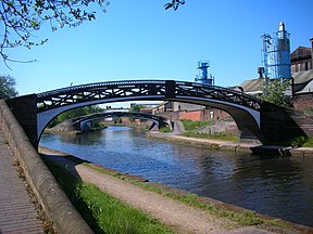
Birmingham Canal Navigations (BCN) is a network of canals connecting Birmingham, Wolverhampton, and the eastern part of the Black Country. The BCN is connected to the rest of the English canal system at several junctions.

Spon Lane Locks Branch

The Spon Lane Locks Branch is an 800-yard section of the BCN Main Line canal in Oldbury, England, which forms a connecting canal "sliproad" where the Old BCN Main Line crosses the New BCN Main Line at the Stewart Aqueduct. It runs westwards from Spon Lane Junction via the three Spon Lane Locks to Bromford Junction. It was originally part of the Wednesbury branch of Birmingham Canal which opened in 1769. At the top lock, there is a rare example of a split bridge, which enabled a horse to cross the canal without being detached from the barge. The rope passed through a gap at the centre of the bridge between its two halves. However, this particular example is a modern reconstruction, dating from 1986. These are probably the oldest working locks in the country. There is pedestrian access to a tow path for its entire length, but being narrow and muddy, it is not suitable for cyclists.

Engine Arm

The Engine Arm or Birmingham Feeder Arm near Smethwick, West Midlands, England, is a short canal which was originally part of a feeder tunnel for a pumping engine. When the Smethwick flight of locks were reduced from six to three, the pumping engine was moved to a new site, which allowed part of the feeder tunnel to be opened up and made navigable, so that coal supplies for the engine could be delivered by barge. The Engine Arm also supplied the pumped water to the 473-foot (144 m) Wolverhampton level of the lowered summit. The arm was extended between 1825 and 1830 by Thomas Telford to carry water from Rotton Park Reservoir to the Old Main Line of the BCN Main Line Canal, and the Engine Arm Aqueduct was inserted to carry it over the new main line constructed at that time, which was 20 feet (6.1 m) lower. The arm is now managed by the Canal and River Trust and the basin beyond the site of the pumping station, which was replaced by a new engine house near Brasshouse Lane bridge in 1892, is used for residential moorings.

Autherley Junction

Autherley Junction is the name of the canal junction where the Shropshire Union Canal terminates and meets the Staffordshire and Worcestershire Canal near to Oxley, north Wolverhampton, West Midlands, England.

Aldersley Junction Canal junction

Aldersley Junction is the name of the canal junction where the Birmingham Main Line Canal terminates and meets the Staffordshire and Worcestershire Canal near to Oxley, north Wolverhampton, West Midlands, England. It opened in 1772.

The BCN Main Line, or Birmingham Canal Navigations Main Line describes the evolving route of the Birmingham Canal between Birmingham and Wolverhampton in England.

Water levels of the Birmingham Canal Navigations

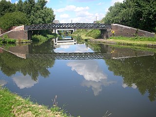
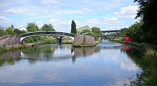
The Birmingham Canal Navigations (BCN), a network of narrow canals in the industrial midlands of England, is built on various water levels. The three longest are the Wolverhampton, Birmingham, and Walsall levels. Locks allow boats to move from one level to another.

Titford Canal

The Titford Canal is a narrow (7 foot) canal, a short branch of the Birmingham Canal Navigations (BCN) in Oldbury, West Midlands, England.

Four Counties Ring

The Four Counties Ring is a canal ring which links the four English counties of Cheshire, Staffordshire, Shropshire and the West Midlands.

Rushall Junction Canal junction

Rushall Junction is the southern limit of the Rushall Canal where it meets the Tame Valley Canal in the West Midlands, England. It opened in 1847, when the Rushall Canal was built to create connections between the Birmingham Canal Navigations system and the Wyrley and Essington Canal, following the amalgamation of the two companies in 1840.

Tame Valley Junction Canal junction

Tame Valley Junction, also known as Doe Bank Junction, is a canal junction at the western limit of the Tame Valley Canal where it meets the Walsall Canal, south of Walsall, in the West Midlands, England.

Horseley Fields Junction

Horseley Fields Junction is a canal junction at the western limit of the Wyrley and Essington Canal where it meets the BCN Main Line, at Horseley Fields east of Wolverhampton, in the West Midlands, England.

Catshill Junction

Catshill Junction is a canal junction at the northern limit of the Daw End Branch Canal where it meets the Wyrley and Essington Canal main line, near Brownhills, in West Midlands, England.

Pelsall Junction Canal junction in England

Pelsall Junction is a canal junction at the southern limit of the Cannock Extension Canal where it meets the Wyrley and Essington Canal main line, near Pelsall, West Midlands, England.

Birchills Junction

Birchills Junction is the canal junction at the northern limit of what is now called the Walsall Canal where it meets the Wyrley and Essington Canal main line, near Walsall, West Midlands, England. It opened in 1798, but lasted for little more than a year, until it was re-opened in 1841 when a connecting link was built to the Birmingham Canal Navigations' southern route to Walsall.

Wednesbury Old Canal

Wednesbury Old Canal is part of the Birmingham Canal Navigations (BCN) in West Midlands (county), England. It opened in 1769, and although parts of it were abandoned in 1955 and 1960, the section between Pudding Green Junction and Ryder's Green Junction is navigable, as it provides a link to the Walsall Canal. A short stub beyond Ryder's Green Junction is connected to the network but difficult to navigate.

Spon Lane Junction

Spon Lane Junction is the original junction of the Wednesbury Canal and the Birmingham Canal, near Oldbury in the West Midlands, England.

Bromford Junction

Bromford Junction is a canal junction at the foot of the Spon Lane Locks where the Spon Lane Locks Branch meets the BCN New Main Line near Oldbury in the West Midlands, England.

Wednesbury Oak Loop

The Wednesbury Oak Loop, sometimes known as the Bradley Arm, is a canal in the West Midlands, England. It is part of the Birmingham Canal Navigations (BCN), and was originally part of James Brindley's main line, but became a loop when Thomas Telford's improvements of the 1830s bypassed it by the construction of the Coseley Tunnel. The south-eastern end of the loop was closed and in parts built over, following the designation of the entire loop as "abandoned" in 1954, including the section which was filled in at the beginning of the 1960s to make way for the Glebefields Estate in Tipton.
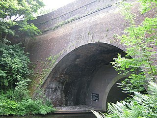
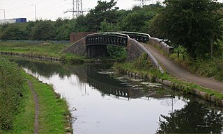
References

Coordinates: 52°29′56″N1°57′31″W / 52.4988°N 1.9587°W / 52.4988; -1.9587