Darnen Township, Stevens County, Minnesota

Last updated

Darnen Township, Minnesota
USA Minnesota location map.svg
Red pog.svg
Darnen Township, Minnesota
Location within the state of Minnesota
Usa edcp location map.svg
Red pog.svg
Darnen Township, Minnesota
Darnen Township, Minnesota (the United States)
Coordinates: 45°33′26″N95°55′22″W / 45.55722°N 95.92278°W / 45.55722; -95.92278
Country United States
State Minnesota
County Stevens
Area
  Total33.2 sq mi (85.9 km2)
  Land32.8 sq mi (85.1 km2)
  Water0.3 sq mi (0.9 km2)
Elevation
1,109 ft (338 m)
Population
 (2000)
  Total325
  Density9.9/sq mi (3.8/km2)
Time zone UTC-6 (Central (CST))
  Summer (DST) UTC-5 (CDT)
FIPS code 27-14824 [1]
GNIS feature ID0663927 [2]

Darnen Township is a township in Stevens County, Minnesota, United States. The population was 325 at the 2000 census.

Contents

History

The first permanent settlement at Darnen Township was made in 1866. [3]

Geography

According to the United States Census Bureau, the township has a total area of 33.2 square miles (86 km2), of which 32.8 square miles (85 km2) is land and 0.3 square miles (0.78 km2) (0.99%) is water.

Demographics

As of the census [1] of 2000, there were 325 people, 105 households, and 91 families residing in the township. The population density was 9.9 inhabitants per square mile (3.8/km2). There were 106 housing units at an average density of 3.2 per square mile (1.2/km2). The racial makeup of the township was 100.00% White.

There were 105 households, out of which 38.1% had children under the age of 18 living with them, 81.9% were married couples living together, 1.0% had a female householder with no husband present, and 13.3% were non-families. 9.5% of all households were made up of individuals, and 3.8% had someone living alone who was 65 years of age or older. The average household size was 3.10 and the average family size was 3.32.

In the township the population was spread out, with 26.2% under the age of 18, 9.2% from 18 to 24, 25.8% from 25 to 44, 24.9% from 45 to 64, and 13.8% who were 65 years of age or older. The median age was 38 years. For every 100 females, there were 108.3 males. For every 100 females age 18 and over, there were 106.9 males.

The median income for a household in the township was $51,875, and the median income for a family was $56,250. Males had a median income of $29,063 versus $24,464 for females. The per capita income for the township was $22,645. About 2.2% of families and 3.3% of the population were below the poverty line, including none of those under the age of eighteen or sixty-five or over.

Related Research Articles

Rice Township is a township in Clearwater County, Minnesota, United States. The population was 134 at the 2000 census. Rice Township was named after the Wild Rice River.

Center Township is a township in Crow Wing County, Minnesota, United States. The population was 808 at the 2000 census.

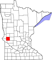
Carlston Township is a township in Freeborn County, Minnesota, United States. The population was 332 at the 2000 census.

Schoolcraft Township is a township in Hubbard County, Minnesota, United States. The population was 106 at the 2000 census.

Balsam Township is a township in Itasca County, Minnesota, United States. The population was 550 at the 2010 census.

Bowstring Township is a township in Itasca County, Minnesota, United States. The population was 230 at the 2010 census.

Good Hope Township is a township in Itasca County, Minnesota, United States. The population was 99 at the 2010 census.

Marcell Township is a township in Itasca County, Minnesota, United States. The population was 467 at the 2010 census.

Spang Township is a township in Itasca County, Minnesota, United States. The population was 264 at the 2010 census.

Center Creek Township is a township in Martin County, Minnesota, United States. The population was 269 at the 2000 census.

Bygland Township is a township in Polk County, Minnesota, United States. The population was 297 at the 2000 census. It is part of the Grand Forks-ND-MN Metropolitan Statistical Area.

Euclid Township is a township in Polk County, Minnesota, United States. It is part of the Grand Forks-ND-MN Metropolitan Statistical Area. The population was 149 at the 2000 census.

Hill River Township is a township in Polk County, Minnesota, United States. It is part of the Grand Forks-ND-MN Metropolitan Statistical Area. The population was 162 at the 2000 census.

Troy Township is a township in Renville County, Minnesota, United States. The population was 325 at the 2000 census.

Pohlitz Township is a township in Roseau County, Minnesota, United States. The population was 36 at the 2000 census.

Livonia Township is a township in Sherburne County, Minnesota, United States. The population was 3,917 at the 2000 census.

Floodwood Township is a township in Saint Louis County, Minnesota, United States. The population was 280 at the 2010 census. The township took its name from the Floodwood River.

Holding Township is a township in Stearns County, Minnesota, United States. It includes the city of Holdingford. The township population was 1,139 at the 2010 census.

Meriden Township is a township in Steele County, Minnesota, United States. The population was 631 at the 2000 census.

Six Mile Grove Township is a township in Swift County, Minnesota, United States. The population was 171 at the 2000 census.

References

  1. 1 2 "U.S. Census website". United States Census Bureau . Retrieved January 31, 2008.
  2. "US Board on Geographic Names". United States Geological Survey. October 25, 2007. Retrieved January 31, 2008.
  3. Upham, Warren (1920). Minnesota Geographic Names: Their Origin and Historic Significance. Minnesota Historical Society. p.  535.